
Station XB NIUE - Niue Island
Network: XB93 - Southwest Pacific Seismic Experiment
Nearby stations (2 deg radius)
| Station | Name | (Lat, Lon) | Start / End | Elevation |
| NIUE | Niue Island | (-18.98, -169.88) | 1993-12-11 / 1995-12-31 | 5.0 m |
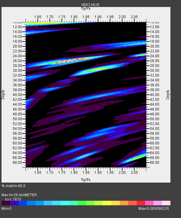
| Crust2 Type: | A0,normal oceanic, 0.07 km seds. |
| Thickness Estimate: | 26 km |
| Thickness StdDev: | 0.4 km |
| Vp/Vs Estimate: | 1.77 |
| Vp/Vs StdDev: | 0.13 |
| Vs Estimate: | 2.399 km/s |
| Poisson's Ratio: | 0.26 |
| Peak Value: | 0.07 |
| Assumed Vp: | 4.24 km/s |
| Ps Weight: | 0.33333334 |
| PpPs Weight: | 0.33333334 |
| PsPs Weight: | 0.33333328 |
| Residual Complexity: | 0.765 |
| Nearby stations H: | +- |
| (2.0 deg) Vp/Vs: | +- |
1 with match > 90% ( 5.882353 %) and 2 with match > 80% ( 11.764706 %) out of 17.
Download stack as xyz text file.
Azimuth Distribution of Events:

Prior Results for this Station
| Study | Thickness | Vp/Vs | Vp | Vs | Poissons Ratio | Extra |
| EARS | 26 km | 1.77 | 4.24 km/s | 2.399 km/s | 0.26 | |
| Crust2.0 | 12 km | 2.19 | 4.24 km/s | 1.94 km/s | 0.37 | A0,normal oceanic, 0.07 km seds. |
| Global Maxima | 26 km | 1.77 | 4.24 km/s | 2.399 km/s | 0.26 | amp=0.069598235 |
| Local Maxima 1 | 10 km | 1.65 | 4.24 km/s | 2.562 km/s | 0.21 | amp=0.047134537 |
| Local Maxima 2 | 30 km | 1.89 | 4.24 km/s | 2.24 km/s | 0.31 | amp=0.041945595 |
| Local Maxima 3 | 66 km | 2.07 | 4.24 km/s | 2.053 km/s | 0.35 | amp=0.038917225 |
| Local Maxima 4 | 65 km | 1.84 | 4.24 km/s | 2.304 km/s | 0.29 | amp=0.024723778 |
| Predicted Arrivals for vertical incidence (zero ray parameter) | |
| Ps | 4.71 SECOND |
| PpPs | 16.97 SECOND |
| PsPs/PpSs | 21.68 SECOND |
Events Processed for this Station
Download zip of receiver functions as SAC
Plot maxima for each earthquake.
Events Used in the Stack
(2 events)| Radial Match | Distance | Baz | FERegion | Time | Lat/Lon | Depth | Magnitude |
| 91.670204 | 73.7 deg | 329.111 deg | Kuril Islands | 1994/10/04 13:22:58 GMT | (43.7, 147.3) | 33 km | 7.4 MB, 8.1 MS, 8.3 UNKNOWN, 8.2 MW |
| 85.76315 | 73.9 deg | 329.139 deg | Kuril Islands | 1994/10/04 14:12:04 GMT | (43.9, 147.1) | 33 km | 5.5 MB |
Losers
(15 events)| Radial Match | Distance | Baz | FERegion | Time | Lat/Lon | Depth | Magnitude | Reason |
| 87.900665 | 73.3 deg | 324.691 deg | Off East Coast Of Honshu, Japan | 1994/12/28 12:29:21 GMT | (40.5, 143.6) | 33 km | 5.6 MB | |
| 78.78005 | 40.2 deg | 285.511 deg | New Britain Region, P.N.G. | 1995/08/14 04:37:17 GMT | (-4.8, 151.5) | 126 km | 6.3 MB, 6.3 MS, 6.4 UNKNOWN | |
| 71.72531 | 63.7 deg | 278.115 deg | Halmahera, Indonesia | 1995/02/13 15:04:26 GMT | (-1.4, 127.5) | 33 km | 6.2 MB, 6.8 MS, 6.8 UNKNOWN, 6.7 MW | |
| 71.02897 | 91.0 deg | 93.275 deg | Peru-Ecuador Border Region | 1995/10/07 21:28:06 GMT | (-2.8, -77.8) | 33 km | 5.8 MB, 5.2 MS, 5.8 UNKNOWN | |
| 70.09005 | 55.1 deg | 279.589 deg | Irian Jaya, Indonesia | 1994/01/19 01:53:36 GMT | (-3.2, 136.0) | 33 km | 6.0 MB, 6.9 MS, 6.9 UNKNOWN | |
| 67.92128 | 73.4 deg | 330.978 deg | Kuril Islands | 1994/05/18 03:54:02 GMT | (44.7, 149.4) | 46 km | 5.8 MB, 5.8 MS, 5.5 UNKNOWN, 6.2 MW | |
| 64.17623 | 89.7 deg | 267.93 deg | Southern Sumatra, Indonesia | 1994/05/11 21:14:34 GMT | (-2.1, 99.7) | 28 km | 5.8 MB, 5.8 MS, 5.8 UNKNOWN, 6.0 MW | |
| 62.88414 | 37.0 deg | 285.82 deg | Solomon Islands | 1995/01/24 22:36:35 GMT | (-5.9, 154.5) | 33 km | 5.7 MB, 6.2 MS, 6.2 UNKNOWN, 6.1 MW | |
| 60.789433 | 63.8 deg | 278.053 deg | Halmahera, Indonesia | 1995/02/13 12:29:55 GMT | (-1.4, 127.4) | 33 km | 5.8 MB, 6.0 MS, 6.1 UNKNOWN, 5.9 MW | |
| 55.820583 | 71.3 deg | 291.009 deg | Samar, Philippines | 1995/05/05 04:39:13 GMT | (12.6, 125.2) | 55 km | 5.6 MB, 6.5 UNKNOWN | |
| 53.137363 | 73.2 deg | 331.297 deg | East Of Kuril Islands | 1994/08/14 01:31:14 GMT | (44.7, 150.0) | 33 km | 6.1 MB, 6.0 MS, 5.6 UNKNOWN, 6.5 MW | |
| 52.299744 | 64.5 deg | 121.744 deg | Southern Pacific Ocean | 1994/06/27 04:10:09 GMT | (-36.2, -98.2) | 10 km | 5.5 MB, 5.5 MS | |
| 51.53437 | 63.8 deg | 277.778 deg | Halmahera, Indonesia | 1995/06/28 21:14:49 GMT | (-1.6, 127.4) | 33 km | 5.6 MB, 5.4 MS, 5.9 UNKNOWN | |
| 46.577526 | 98.2 deg | 87.444 deg | Colombia | 1995/01/19 15:05:03 GMT | (5.1, -72.9) | 18 km | 6.4 MB, 6.6 MS, 6.5 UNKNOWN, 6.5 MW | |
| 46.29092 | 93.7 deg | 109.776 deg | Peru-Bolivia Border Region | 1994/12/12 07:41:55 GMT | (-17.5, -69.7) | 151 km | 5.8 MB, 6.1 UNKNOWN, 6.3 MW |
