
Station XB ALQN - XB.ALQN
Network: XB96 - Abitibi Experiment
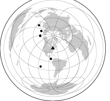
Nearby stations (2 deg radius)
| Station | Name | (Lat, Lon) | Start / End | Elevation |
| ALQN | XB.ALQN | (45.74, -78.19) | 1996-05-22 / 1996-12-31 | 0.0 m |
| Crust2 Type: | H3,early/mid Proter. shield, Finland, 0.5 km seds. |
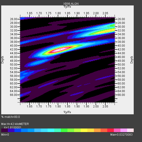
| Thickness Estimate: | 42 km |
| Thickness StdDev: | 3.8 km |
| Vp/Vs Estimate: | 1.81 |
| Vp/Vs StdDev: | 0.10 |
| Vs Estimate: | 3.634 km/s |
| Poisson's Ratio: | 0.28 |
| Peak Value: | 0.03 |
| Assumed Vp: | 6.577 km/s |
| Ps Weight: | 0.33333334 |
| PpPs Weight: | 0.33333334 |
| PsPs Weight: | 0.33333328 |
| Residual Complexity: | 0.568 |
| Nearby stations H: | +- |
| (2.0 deg) Vp/Vs: | +- |
4 with match > 90% ( 26.666666 %) and 8 with match > 80% ( 53.333332 %) out of 15.
Download stack as xyz text file.
Azimuth Distribution of Events:
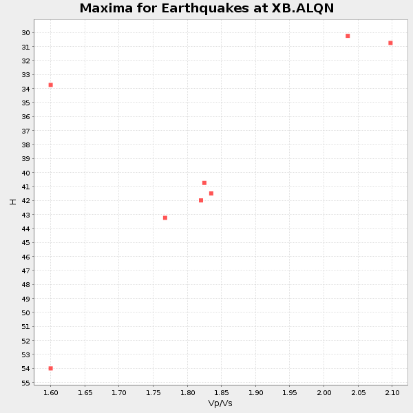
Prior Results for this Station
| Study | Thickness | Vp/Vs | Vp | Vs | Poissons Ratio | Extra |
| EARS | 42 km | 1.81 | 6.577 km/s | 3.634 km/s | 0.28 | |
| Crust2.0 | 46 km | 1.78 | 6.577 km/s | 3.701 km/s | 0.27 | H3,early/mid Proter. shield, Finland, 0.5 km seds. |
| Global Maxima | 42 km | 1.81 | 6.577 km/s | 3.634 km/s | 0.28 | amp=0.03270083 |
| Local Maxima 1 | 32 km | 2.05 | 6.577 km/s | 3.208 km/s | 0.34 | amp=0.021605842 |
| Local Maxima 2 | 29 km | 2.10 | 6.577 km/s | 3.136 km/s | 0.35 | amp=0.01443291 |
| Local Maxima 3 | 44 km | 1.77 | 6.577 km/s | 3.721 km/s | 0.26 | amp=0.0111208735 |
| Local Maxima 4 | 31 km | 2.10 | 6.577 km/s | 3.136 km/s | 0.35 | amp=0.009076745 |
| Predicted Arrivals for vertical incidence (zero ray parameter) | |
| Ps | 5.17 SECOND |
| PpPs | 17.94 SECOND |
| PsPs/PpSs | 23.12 SECOND |
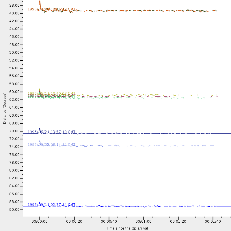
Events Processed for this Station
Download zip of receiver functions as SAC
Plot maxima for each earthquake.
Events Used in the Stack
(8 events)| Radial Match | Distance | Baz | FERegion | Time | Lat/Lon | Depth | Magnitude |
| 98.720314 | 60.9 deg | 315.209 deg | Andreanof Islands, Aleutian Is. | 1996/06/10 04:03:35 GMT | (51.6, -177.6) | 33 km | 6.6 MB, 7.6 MS, 7.9 UNKNOWN, 7.4 MS |
| 97.41434 | 71.2 deg | 326.307 deg | Off East Coast Of Kamchatka | 1996/06/21 13:57:10 GMT | (51.6, 159.1) | 20 km | 6.0 MB, 6.6 MS, 7.0 UNKNOWN, 6.5 MS |
| 95.128654 | 61.2 deg | 315.36 deg | Andreanof Islands, Aleutian Is. | 1996/06/08 23:19:15 GMT | (51.5, -178.1) | 33 km | 5.9 MB, 6.3 MS, 6.5 UNKNOWN, 6.1 MS |
| 93.22004 | 74.7 deg | 213.689 deg | Easter Island Region | 1996/09/05 08:14:14 GMT | (-22.1, -113.4) | 10 km | 6.2 MB, 7.0 MS, 7.0 UNKNOWN, 6.9 MW |
| 88.36655 | 60.4 deg | 314.345 deg | Andreanof Islands, Aleutian Is. | 1996/06/11 10:40:08 GMT | (51.3, -176.3) | 33 km | 5.6 MB, 5.6 MS, 6.0 UNKNOWN, 5.5 MS |
| 85.429214 | 36.6 deg | 190.168 deg | Costa Rica | 1996/08/28 17:16:17 GMT | (9.4, -84.3) | 33 km | 5.5 MB, 5.5 MS, 5.9 UNKNOWN |
| 84.50743 | 36.6 deg | 190.088 deg | Costa Rica | 1996/09/04 19:06:49 GMT | (9.4, -84.3) | 33 km | 5.8 MB, 5.9 MS, 6.2 UNKNOWN, 6.1 MW |
| 80.511246 | 91.7 deg | 329.006 deg | Near East Coast Of Honshu, Japan | 1996/09/11 02:37:14 GMT | (35.5, 140.9) | 55 km | 6.1 MB, 5.7 MS, 6.2 UNKNOWN, 6.1 MW |
Losers
(7 events)| Radial Match | Distance | Baz | FERegion | Time | Lat/Lon | Depth | Magnitude | Reason |
| 78.0399 | 77.5 deg | 174.228 deg | Near Coast Of Central Chile | 1996/09/09 00:20:39 GMT | (-31.9, -71.6) | 39 km | 6.0 MB, 5.5 MS, 6.0 UNKNOWN, 5.8 ME | |
| 70.414246 | 71.1 deg | 326.118 deg | Off East Coast Of Kamchatka | 1996/06/23 12:45:06 GMT | (51.6, 159.5) | 33 km | 5.3 MB, 6.1 MS | |
| 67.74194 | 69.1 deg | 172.347 deg | Near Coast Of Northern Chile | 1996/07/03 16:48:27 GMT | (-23.4, -70.4) | 33 km | 5.3 MB, 5.4 MS, 5.8 UNKNOWN | |
| 66.556854 | 61.3 deg | 315.335 deg | Andreanof Islands, Aleutian Is. | 1996/06/12 02:16:48 GMT | (51.4, -178.2) | 33 km | 5.5 MB, 5.3 MS, 5.7 UNKNOWN, 5.6 ML | |
| 66.52279 | 73.4 deg | 330.773 deg | Sea Of Okhotsk | 1996/08/30 21:13:41 GMT | (52.3, 151.5) | 580 km | 5.5 UNKNOWN, 5.1 MB, 5.4 MW | |
| 52.346607 | 34.7 deg | 192.594 deg | Nicaragua | 1996/09/18 17:34:20 GMT | (11.4, -85.5) | 193 km | 5.7 UNKNOWN, 5.3 MB, 5.5 MW | |
| 50.90955 | 71.3 deg | 326.133 deg | Off East Coast Of Kamchatka | 1996/06/22 14:50:07 GMT | (51.4, 159.2) | 33 km | 5.6 MB, 6.0 MS, 6.2 UNKNOWN, 6.2 MW |
