
Station XB BISC - Bisset Creek (On)
Network: XB96 - Abitibi Experiment
Nearby stations (2 deg radius)
| Station | Name | (Lat, Lon) | Start / End | Elevation |
| BISC | Bisset Creek (On) | (46.03, -78.24) | 1996-05-22 / 1996-12-31 | 0.0 m |
| Crust2 Type: | H2,early/mid Proter. shield, Finland, no seds. |
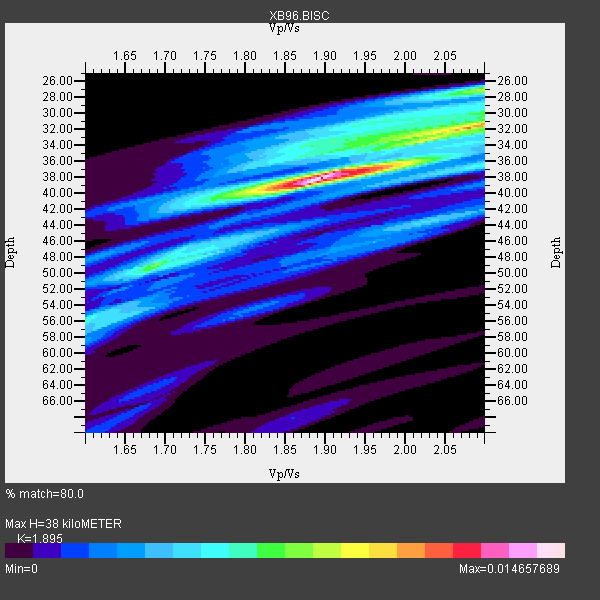
| Thickness Estimate: | 38 km |
| Thickness StdDev: | 4.6 km |
| Vp/Vs Estimate: | 1.89 |
| Vp/Vs StdDev: | 0.10 |
| Vs Estimate: | 3.495 km/s |
| Poisson's Ratio: | 0.31 |
| Peak Value: | 0.01 |
| Assumed Vp: | 6.622 km/s |
| Ps Weight: | 0.33333334 |
| PpPs Weight: | 0.33333334 |
| PsPs Weight: | 0.33333328 |
| Residual Complexity: | 0.683 |
| Nearby stations H: | +- |
| (2.0 deg) Vp/Vs: | +- |
5 with match > 90% ( 26.31579 %) and 7 with match > 80% ( 36.842106 %) out of 19.
Download stack as xyz text file.
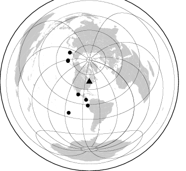
Azimuth Distribution of Events:
Prior Results for this Station
| Study | Thickness | Vp/Vs | Vp | Vs | Poissons Ratio | Extra |
| EARS | 38 km | 1.89 | 6.622 km/s | 3.495 km/s | 0.31 | |
| Crust2.0 | 45 km | 1.78 | 6.622 km/s | 3.729 km/s | 0.27 | H2,early/mid Proter. shield, Finland, no seds. |
| Global Maxima | 38 km | 1.89 | 6.622 km/s | 3.495 km/s | 0.31 | amp=0.014657689 |
| Local Maxima 1 | 32 km | 2.08 | 6.622 km/s | 3.184 km/s | 0.35 | amp=0.00897635 |
| Local Maxima 2 | 27 km | 2.10 | 6.622 km/s | 3.157 km/s | 0.35 | amp=0.008322367 |
| Local Maxima 3 | 49 km | 1.69 | 6.622 km/s | 3.918 km/s | 0.23 | amp=0.005405147 |
| Local Maxima 4 | 36 km | 2.10 | 6.622 km/s | 3.157 km/s | 0.35 | amp=0.0042642187 |
| Predicted Arrivals for vertical incidence (zero ray parameter) | |
| Ps | 5.14 SECOND |
| PpPs | 16.61 SECOND |
| PsPs/PpSs | 21.75 SECOND |
Events Processed for this Station
Download zip of receiver functions as SAC
Plot maxima for each earthquake.
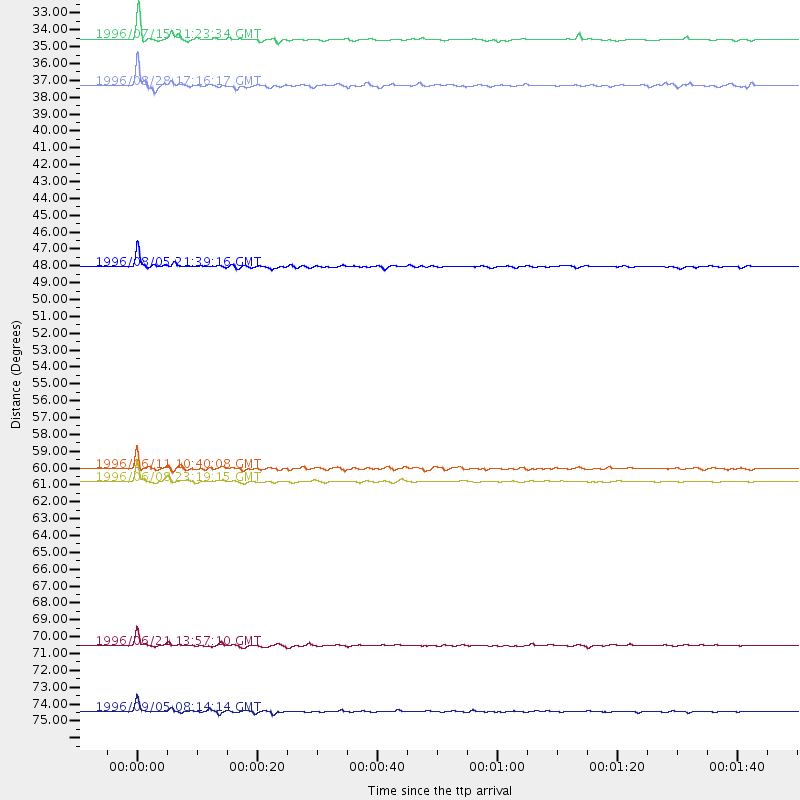
Events Used in the Stack
(7 events)| Radial Match | Distance | Baz | FERegion | Time | Lat/Lon | Depth | Magnitude |
| 96.24224 | 71.0 deg | 326.225 deg | Off East Coast Of Kamchatka | 1996/06/21 13:57:10 GMT | (51.6, 159.1) | 20 km | 6.0 MB, 6.6 MS, 7.0 UNKNOWN, 6.5 MS |
| 94.85572 | 47.9 deg | 183.72 deg | Off Coast Of Ecuador | 1996/08/05 21:39:16 GMT | (-2.0, -81.0) | 33 km | 5.7 MB, 5.9 MS, 6.2 UNKNOWN, 6.2 MW |
| 94.79432 | 61.0 deg | 315.226 deg | Andreanof Islands, Aleutian Is. | 1996/06/08 23:19:15 GMT | (51.5, -178.1) | 33 km | 5.9 MB, 6.3 MS, 6.5 UNKNOWN, 6.1 MS |
| 94.35769 | 75.0 deg | 213.601 deg | Easter Island Region | 1996/09/05 08:14:14 GMT | (-22.1, -113.4) | 10 km | 6.2 MB, 7.0 MS, 7.0 UNKNOWN, 6.9 MW |
| 91.93438 | 34.1 deg | 221.145 deg | Guerrero, Mexico | 1996/07/15 21:23:34 GMT | (17.6, -101.0) | 18 km | 5.7 MB, 6.5 MS, 6.6 UNKNOWN, 6.2 ME |
| 86.17344 | 36.9 deg | 190.015 deg | Costa Rica | 1996/08/28 17:16:17 GMT | (9.4, -84.3) | 33 km | 5.5 MB, 5.5 MS, 5.9 UNKNOWN |
| 82.45001 | 60.2 deg | 314.205 deg | Andreanof Islands, Aleutian Is. | 1996/06/11 10:40:08 GMT | (51.3, -176.3) | 33 km | 5.6 MB, 5.6 MS, 6.0 UNKNOWN, 5.5 MS |
Losers
(12 events)| Radial Match | Distance | Baz | FERegion | Time | Lat/Lon | Depth | Magnitude | Reason |
| 76.88361 | 66.0 deg | 331.643 deg | Kamchatka Peninsula, Russia | 1996/07/07 10:49:59 GMT | (58.6, 157.8) | 10 km | 5.6 MB, 5.6 MS, 5.8 UNKNOWN, 5.8 MW | |
| 72.4573 | 61.1 deg | 315.296 deg | Andreanof Islands, Aleutian Is. | 1996/08/19 04:19:16 GMT | (51.5, -178.4) | 33 km | 5.7 MB, 5.6 MS, 6.0 UNKNOWN, 5.7 ML | |
| 72.23126 | 77.8 deg | 174.19 deg | Near Coast Of Central Chile | 1996/09/09 00:20:39 GMT | (-31.9, -71.6) | 39 km | 6.0 MB, 5.5 MS, 6.0 UNKNOWN, 5.8 ME | |
| 66.45003 | 57.1 deg | 312.884 deg | Fox Islands, Aleutian Islands | 1996/07/10 05:48:19 GMT | (52.2, -171.1) | 33 km | 5.9 ML, 5.4 MS, 5.3 MB | |
| 62.34069 | 91.5 deg | 328.972 deg | Near East Coast Of Honshu, Japan | 1996/09/11 02:37:14 GMT | (35.5, 140.9) | 55 km | 6.1 MB, 5.7 MS, 6.2 UNKNOWN, 6.1 MW | |
| 58.664543 | 91.9 deg | 9.761 deg | Southern Xinjiang, China | 1996/06/08 02:55:57 GMT | (41.7, 88.7) | 0.0 km | 5.9 MB, 4.3 MS | |
| 57.9483 | 73.2 deg | 330.703 deg | Sea Of Okhotsk | 1996/08/30 21:13:41 GMT | (52.3, 151.5) | 580 km | 5.5 UNKNOWN, 5.1 MB, 5.4 MW | |
| 56.9918 | 88.6 deg | 330.744 deg | Eastern Honshu, Japan | 1996/08/10 18:12:17 GMT | (38.9, 140.5) | 10 km | 6.0 MB, 5.7 MS, 5.9 UNKNOWN, 5.9 MW | |
| 56.555714 | 71.1 deg | 326.051 deg | Off East Coast Of Kamchatka | 1996/06/22 14:50:07 GMT | (51.4, 159.2) | 33 km | 5.6 MB, 6.0 MS, 6.2 UNKNOWN, 6.2 MW | |
| 54.485527 | 75.2 deg | 46.055 deg | Turkey | 1996/08/14 01:55:02 GMT | (40.8, 35.3) | 10 km | 5.6 MS, 5.3 MB, 5.8 UNKNOWN, 5.7 MW | |
| 54.25908 | 61.1 deg | 315.2 deg | Andreanof Islands, Aleutian Is. | 1996/06/12 02:16:48 GMT | (51.4, -178.2) | 33 km | 5.5 MB, 5.3 MS, 5.7 UNKNOWN, 5.6 ML | |
| 51.663734 | 70.9 deg | 326.009 deg | Off East Coast Of Kamchatka | 1996/07/18 22:55:03 GMT | (51.5, 159.4) | 33 km | 5.5 MB, 5.2 MS |
