
Station XB CARO - XB.CARO
Network: XB96 - Abitibi Experiment
Nearby stations (2 deg radius)
| Station | Name | (Lat, Lon) | Start / End | Elevation |
| CARO | XB.CARO | (47.92, -78.98) | 1996-05-16 / 1996-12-31 | 0.0 m |
| Crust2 Type: | H2,early/mid Proter. shield, Finland, no seds. |
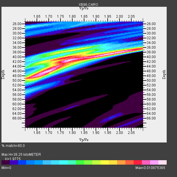
| Thickness Estimate: | 38 km |
| Thickness StdDev: | 3.6 km |
| Vp/Vs Estimate: | 1.98 |
| Vp/Vs StdDev: | 0.11 |
| Vs Estimate: | 3.349 km/s |
| Poisson's Ratio: | 0.33 |
| Peak Value: | 0.01 |
| Assumed Vp: | 6.622 km/s |
| Ps Weight: | 0.33333334 |
| PpPs Weight: | 0.33333334 |
| PsPs Weight: | 0.33333328 |
| Residual Complexity: | 0.814 |
| Nearby stations H: | +- |
| (2.0 deg) Vp/Vs: | +- |
8 with match > 90% ( 29.62963 %) and 13 with match > 80% ( 48.148148 %) out of 27.
Download stack as xyz text file.
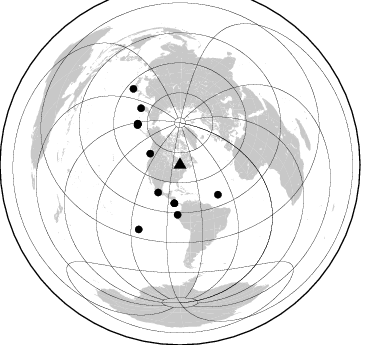
Azimuth Distribution of Events:
Prior Results for this Station
| Study | Thickness | Vp/Vs | Vp | Vs | Poissons Ratio | Extra |
| EARS | 38 km | 1.98 | 6.622 km/s | 3.349 km/s | 0.33 | |
| Crust2.0 | 45 km | 1.78 | 6.622 km/s | 3.729 km/s | 0.27 | H2,early/mid Proter. shield, Finland, no seds. |
| Global Maxima | 38 km | 1.98 | 6.622 km/s | 3.349 km/s | 0.33 | amp=0.010875365 |
| Local Maxima 1 | 46 km | 1.70 | 6.622 km/s | 3.907 km/s | 0.23 | amp=0.01044445 |
| Local Maxima 2 | 42 km | 1.78 | 6.622 km/s | 3.72 km/s | 0.27 | amp=0.0081139505 |
| Local Maxima 3 | 38 km | 1.73 | 6.622 km/s | 3.828 km/s | 0.25 | amp=0.0064443783 |
| Local Maxima 4 | 49 km | 1.62 | 6.622 km/s | 4.088 km/s | 0.19 | amp=0.0059213866 |
| Predicted Arrivals for vertical incidence (zero ray parameter) | |
| Ps | 5.65 SECOND |
| PpPs | 17.20 SECOND |
| PsPs/PpSs | 22.84 SECOND |
Events Processed for this Station
Download zip of receiver functions as SAC
Plot maxima for each earthquake.
Events Used in the Stack
(13 events)| Radial Match | Distance | Baz | FERegion | Time | Lat/Lon | Depth | Magnitude |
| 98.48063 | 58.7 deg | 313.519 deg | Andreanof Islands, Aleutian Is. | 1996/06/10 15:24:56 GMT | (51.5, -176.8) | 26 km | 5.9 MB, 7.1 MS, 7.2 UNKNOWN, 6.9 MS |
| 97.92205 | 59.0 deg | 313.958 deg | Andreanof Islands, Aleutian Is. | 1996/06/10 04:03:35 GMT | (51.6, -177.6) | 33 km | 6.6 MB, 7.6 MS, 7.9 UNKNOWN, 7.4 MS |
| 96.03345 | 69.1 deg | 325.454 deg | Off East Coast Of Kamchatka | 1996/06/21 13:57:10 GMT | (51.6, 159.1) | 20 km | 6.0 MB, 6.6 MS, 7.0 UNKNOWN, 6.5 MS |
| 93.83908 | 59.3 deg | 314.12 deg | Andreanof Islands, Aleutian Is. | 1996/06/08 23:19:15 GMT | (51.5, -178.1) | 33 km | 5.9 MB, 6.3 MS, 6.5 UNKNOWN, 6.1 MS |
| 93.68934 | 48.1 deg | 127.906 deg | Northern Mid-Atlantic Ridge | 1996/06/02 02:52:09 GMT | (10.8, -42.3) | 10 km | 6.1 MB, 6.9 MS, 7.0 UNKNOWN, 6.8 MW |
| 92.43001 | 35.2 deg | 218.294 deg | Guerrero, Mexico | 1996/07/15 21:23:34 GMT | (17.6, -101.0) | 18 km | 5.7 MB, 6.5 MS, 6.6 UNKNOWN, 6.2 ME |
| 92.2793 | 49.7 deg | 182.648 deg | Off Coast Of Ecuador | 1996/08/05 21:39:16 GMT | (-2.0, -81.0) | 33 km | 5.7 MB, 5.9 MS, 6.2 UNKNOWN, 6.2 MW |
| 91.60049 | 76.3 deg | 212.689 deg | Easter Island Region | 1996/09/05 08:14:14 GMT | (-22.1, -113.4) | 10 km | 6.2 MB, 7.0 MS, 7.0 UNKNOWN, 6.9 MW |
| 89.327446 | 89.6 deg | 328.438 deg | Near East Coast Of Honshu, Japan | 1996/09/11 02:37:14 GMT | (35.5, 140.9) | 55 km | 6.1 MB, 5.7 MS, 6.2 UNKNOWN, 6.1 MW |
| 89.30275 | 38.7 deg | 188.365 deg | Costa Rica | 1996/09/04 19:06:49 GMT | (9.4, -84.3) | 33 km | 5.8 MB, 5.9 MS, 6.2 UNKNOWN, 6.1 MW |
| 87.04691 | 38.7 deg | 188.441 deg | Costa Rica | 1996/08/28 17:16:17 GMT | (9.4, -84.3) | 33 km | 5.5 MB, 5.5 MS, 5.9 UNKNOWN |
| 84.11036 | 32.0 deg | 290.621 deg | Vancouver Island, Canada Region | 1996/10/06 20:13:09 GMT | (49.0, -127.9) | 10 km | 5.8 MB, 6.3 MS, 6.2 UNKNOWN, 6.2 MW |
| 80.69269 | 58.5 deg | 313.063 deg | Andreanof Islands, Aleutian Is. | 1996/06/11 10:40:08 GMT | (51.3, -176.3) | 33 km | 5.6 MB, 5.6 MS, 6.0 UNKNOWN, 5.5 MS |
Losers
(14 events)| Radial Match | Distance | Baz | FERegion | Time | Lat/Lon | Depth | Magnitude | Reason |
| 79.091125 | 79.7 deg | 173.591 deg | Near Coast Of Central Chile | 1996/09/09 00:20:39 GMT | (-31.9, -71.6) | 39 km | 6.0 MB, 5.5 MS, 6.0 UNKNOWN, 5.8 ME | |
| 76.01517 | 77.4 deg | 52.085 deg | Cyprus Region | 1996/10/09 13:10:52 GMT | (34.6, 32.1) | 33 km | 6.4 MB, 6.8 MS, 7.2 UNKNOWN, 6.8 MW | |
| 72.34413 | 64.1 deg | 330.888 deg | Kamchatka Peninsula, Russia | 1996/07/07 10:49:59 GMT | (58.6, 157.8) | 10 km | 5.6 MB, 5.6 MS, 5.8 UNKNOWN, 5.8 MW | |
| 70.70457 | 55.4 deg | 311.639 deg | Fox Islands, Aleutian Islands | 1996/07/10 05:48:19 GMT | (52.2, -171.1) | 33 km | 5.9 ML, 5.4 MS, 5.3 MB | |
| 67.76224 | 59.4 deg | 314.195 deg | Andreanof Islands, Aleutian Is. | 1996/08/19 04:19:16 GMT | (51.5, -178.4) | 33 km | 5.7 MB, 5.6 MS, 6.0 UNKNOWN, 5.7 ML | |
| 67.46043 | 71.4 deg | 171.688 deg | Near Coast Of Northern Chile | 1996/07/03 16:48:27 GMT | (-23.4, -70.4) | 33 km | 5.3 MB, 5.4 MS, 5.8 UNKNOWN | |
| 66.79157 | 76.1 deg | 212.418 deg | Easter Island Region | 1996/09/05 09:10:20 GMT | (-22.1, -113.1) | 10 km | 5.6 MB, 6.3 MS | |
| 65.99758 | 70.4 deg | 329.767 deg | Northwest Of Kuril Islands | 1996/10/08 07:52:58 GMT | (52.9, 152.5) | 627 km | 5.6 UNKNOWN, 5.2 MB | |
| 64.24995 | 69.1 deg | 325.234 deg | Off East Coast Of Kamchatka | 1996/07/18 22:55:03 GMT | (51.5, 159.4) | 33 km | 5.5 MB, 5.2 MS | |
| 60.459602 | 77.4 deg | 326.17 deg | Kuril Islands | 1996/10/02 11:24:48 GMT | (45.1, 151.2) | 33 km | 6.1 MB, 5.4 MS, 6.0 UNKNOWN, 6.0 MW | |
| 57.512188 | 71.3 deg | 330.006 deg | Sea Of Okhotsk | 1996/08/30 21:13:41 GMT | (52.3, 151.5) | 580 km | 5.5 UNKNOWN, 5.1 MB, 5.4 MW | |
| 50.0914 | 59.4 deg | 314.096 deg | Andreanof Islands, Aleutian Is. | 1996/06/12 02:16:48 GMT | (51.4, -178.2) | 33 km | 5.5 MB, 5.3 MS, 5.7 UNKNOWN, 5.6 ML | |
| 48.776978 | 86.7 deg | 330.185 deg | Eastern Honshu, Japan | 1996/08/10 18:12:17 GMT | (38.9, 140.5) | 10 km | 6.0 MB, 5.7 MS, 5.9 UNKNOWN, 5.9 MW | |
| 47.99035 | 36.8 deg | 190.671 deg | Nicaragua | 1996/09/18 17:34:20 GMT | (11.4, -85.5) | 193 km | 5.7 UNKNOWN, 5.3 MB, 5.5 MW |
