
Station XB MADW - XB.MADW
Network: XB96 - Abitibi Experiment
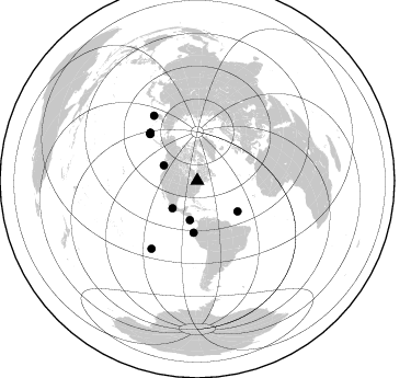
Nearby stations (2 deg radius)

| Station | Name | (Lat, Lon) | Start / End | Elevation |
| MADW | XB.MADW | (45.53, -78.00) | 1996-05-23 / 1996-12-31 | 0.0 m |
| Crust2 Type: | H3,early/mid Proter. shield, Finland, 0.5 km seds. |
| Thickness Estimate: | 41 km |
| Thickness StdDev: | 4.9 km |
| Vp/Vs Estimate: | 1.75 |
| Vp/Vs StdDev: | 0.07 |
| Vs Estimate: | 3.764 km/s |
| Poisson's Ratio: | 0.26 |
| Peak Value: | 0.03 |
| Assumed Vp: | 6.577 km/s |
| Ps Weight: | 0.33333334 |
| PpPs Weight: | 0.33333334 |
| PsPs Weight: | 0.33333328 |
| Residual Complexity: | 0.677 |
| Nearby stations H: | +- |
| (2.0 deg) Vp/Vs: | +- |
9 with match > 90% ( 39.130436 %) and 11 with match > 80% ( 47.826088 %) out of 23.
Download stack as xyz text file.
Azimuth Distribution of Events:
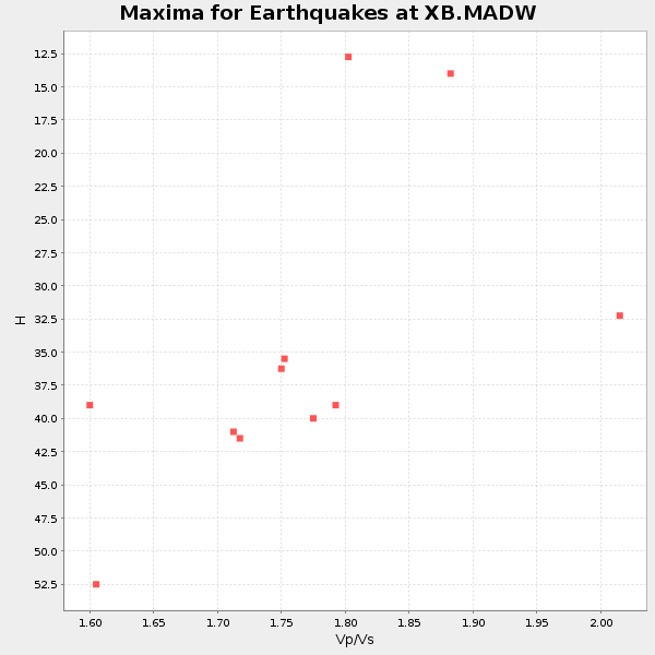
Prior Results for this Station
| Study | Thickness | Vp/Vs | Vp | Vs | Poissons Ratio | Extra |
| EARS | 41 km | 1.75 | 6.577 km/s | 3.764 km/s | 0.26 | |
| Crust2.0 | 46 km | 1.78 | 6.577 km/s | 3.701 km/s | 0.27 | H3,early/mid Proter. shield, Finland, 0.5 km seds. |
| Global Maxima | 41 km | 1.75 | 6.577 km/s | 3.764 km/s | 0.26 | amp=0.02631464 |
| Local Maxima 1 | 54 km | 1.60 | 6.577 km/s | 4.111 km/s | 0.18 | amp=0.019357542 |
| Local Maxima 2 | 33 km | 1.86 | 6.577 km/s | 3.541 km/s | 0.30 | amp=0.01609083 |
| Local Maxima 3 | 43 km | 1.77 | 6.577 km/s | 3.705 km/s | 0.27 | amp=0.012361533 |
| Local Maxima 4 | 52 km | 1.62 | 6.577 km/s | 4.066 km/s | 0.19 | amp=0.008767311 |
| Predicted Arrivals for vertical incidence (zero ray parameter) | |
| Ps | 4.69 SECOND |
| PpPs | 17.23 SECOND |
| PsPs/PpSs | 21.92 SECOND |
Events Processed for this Station
Download zip of receiver functions as SAC
Plot maxima for each earthquake.
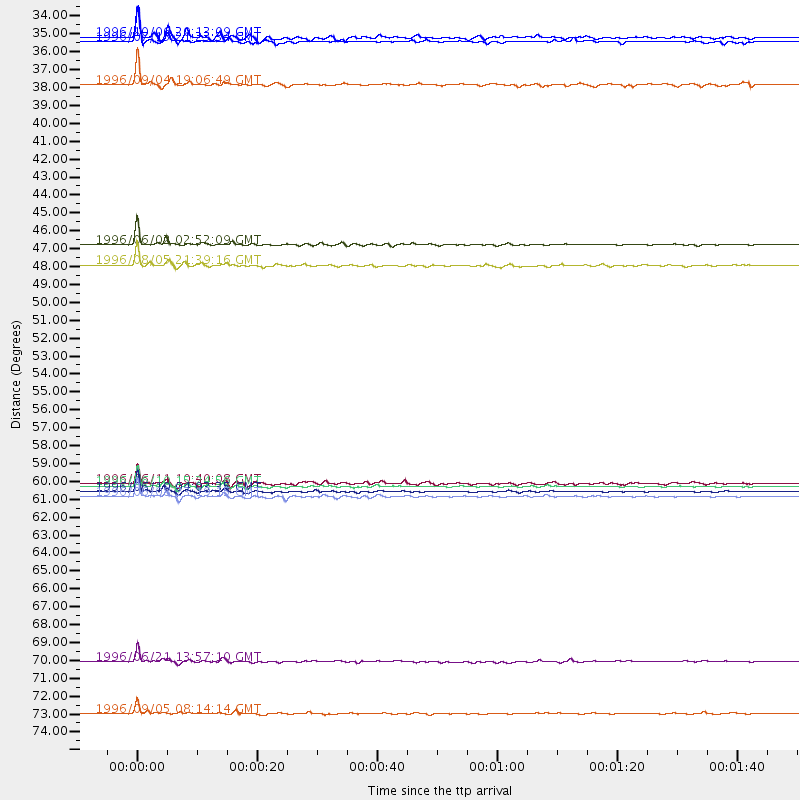
Events Used in the Stack
(11 events)| Radial Match | Distance | Baz | FERegion | Time | Lat/Lon | Depth | Magnitude |
| 98.437935 | 60.8 deg | 314.951 deg | Andreanof Islands, Aleutian Is. | 1996/06/10 15:24:56 GMT | (51.5, -176.8) | 26 km | 5.9 MB, 7.1 MS, 7.2 UNKNOWN, 6.9 MS |
| 98.0953 | 61.2 deg | 315.371 deg | Andreanof Islands, Aleutian Is. | 1996/06/10 04:03:35 GMT | (51.6, -177.6) | 33 km | 6.6 MB, 7.6 MS, 7.9 UNKNOWN, 7.4 MS |
| 95.58846 | 46.1 deg | 127.238 deg | Northern Mid-Atlantic Ridge | 1996/06/02 02:52:09 GMT | (10.8, -42.3) | 10 km | 6.1 MB, 6.9 MS, 7.0 UNKNOWN, 6.8 MW |
| 94.677216 | 47.4 deg | 184.071 deg | Off Coast Of Ecuador | 1996/08/05 21:39:16 GMT | (-2.0, -81.0) | 33 km | 5.7 MB, 5.9 MS, 6.2 UNKNOWN, 6.2 MW |
| 93.74298 | 74.6 deg | 213.882 deg | Easter Island Region | 1996/09/05 08:14:14 GMT | (-22.1, -113.4) | 10 km | 6.2 MB, 7.0 MS, 7.0 UNKNOWN, 6.9 MW |
| 93.638756 | 61.5 deg | 315.522 deg | Andreanof Islands, Aleutian Is. | 1996/06/08 23:19:15 GMT | (51.5, -178.1) | 33 km | 5.9 MB, 6.3 MS, 6.5 UNKNOWN, 6.1 MS |
| 93.51596 | 71.5 deg | 326.441 deg | Off East Coast Of Kamchatka | 1996/06/21 13:57:10 GMT | (51.6, 159.1) | 20 km | 6.0 MB, 6.6 MS, 7.0 UNKNOWN, 6.5 MS |
| 92.25372 | 33.8 deg | 221.989 deg | Guerrero, Mexico | 1996/07/15 21:23:34 GMT | (17.6, -101.0) | 18 km | 5.7 MB, 6.5 MS, 6.6 UNKNOWN, 6.2 ME |
| 91.22761 | 33.5 deg | 294.358 deg | Vancouver Island, Canada Region | 1996/10/06 20:13:09 GMT | (49.0, -127.9) | 10 km | 5.8 MB, 6.3 MS, 6.2 UNKNOWN, 6.2 MW |
| 84.40374 | 60.7 deg | 314.51 deg | Andreanof Islands, Aleutian Is. | 1996/06/11 10:40:08 GMT | (51.3, -176.3) | 33 km | 5.6 MB, 5.6 MS, 6.0 UNKNOWN, 5.5 MS |
| 80.51992 | 36.4 deg | 190.442 deg | Costa Rica | 1996/09/04 19:06:49 GMT | (9.4, -84.3) | 33 km | 5.8 MB, 5.9 MS, 6.2 UNKNOWN, 6.1 MW |
Losers
(12 events)| Radial Match | Distance | Baz | FERegion | Time | Lat/Lon | Depth | Magnitude | Reason |
| 78.10651 | 51.0 deg | 329.764 deg | Near N. Coast Of Eastern Siberia | 1996/10/24 19:31:53 GMT | (67.0, -173.2) | 20 km | 6.0 MB, 5.9 MS, 6.1 UNKNOWN, 5.8 ME | |
| 77.321594 | 78.4 deg | 52.3 deg | Cyprus Region | 1996/10/09 13:10:52 GMT | (34.6, 32.1) | 33 km | 6.4 MB, 6.8 MS, 7.2 UNKNOWN, 6.8 MW | |
| 76.317635 | 61.6 deg | 315.591 deg | Andreanof Islands, Aleutian Is. | 1996/08/19 04:19:16 GMT | (51.5, -178.4) | 33 km | 5.7 MB, 5.6 MS, 6.0 UNKNOWN, 5.7 ML | |
| 72.64077 | 92.0 deg | 329.138 deg | Near East Coast Of Honshu, Japan | 1996/09/11 02:37:14 GMT | (35.5, 140.9) | 55 km | 6.1 MB, 5.7 MS, 6.2 UNKNOWN, 6.1 MW | |
| 69.33663 | 34.6 deg | 192.975 deg | Nicaragua | 1996/09/18 17:34:20 GMT | (11.4, -85.5) | 193 km | 5.7 UNKNOWN, 5.3 MB, 5.5 MW | |
| 64.644424 | 73.7 deg | 330.901 deg | Sea Of Okhotsk | 1996/08/30 21:13:41 GMT | (52.3, 151.5) | 580 km | 5.5 UNKNOWN, 5.1 MB, 5.4 MW | |
| 61.342464 | 68.9 deg | 172.517 deg | Near Coast Of Northern Chile | 1996/07/03 16:48:27 GMT | (-23.4, -70.4) | 33 km | 5.3 MB, 5.4 MS, 5.8 UNKNOWN | |
| 58.224056 | 57.5 deg | 313.214 deg | Fox Islands, Aleutian Islands | 1996/07/10 05:48:19 GMT | (52.2, -171.1) | 33 km | 5.9 ML, 5.4 MS, 5.3 MB | |
| 55.079285 | 89.1 deg | 330.915 deg | Eastern Honshu, Japan | 1996/08/10 18:12:17 GMT | (38.9, 140.5) | 10 km | 6.0 MB, 5.7 MS, 5.9 UNKNOWN, 5.9 MW | |
| 54.12484 | 61.5 deg | 315.496 deg | Andreanof Islands, Aleutian Is. | 1996/06/12 02:16:48 GMT | (51.4, -178.2) | 33 km | 5.5 MB, 5.3 MS, 5.7 UNKNOWN, 5.6 ML | |
| 51.630657 | 54.7 deg | 212.874 deg | Central East Pacific Rise | 1996/08/23 21:56:06 GMT | (-4.1, -104.4) | 10 km | 5.0 MB, 5.6 MS | |
| 47.068726 | 79.8 deg | 327.029 deg | Kuril Islands | 1996/10/02 11:24:48 GMT | (45.1, 151.2) | 33 km | 6.1 MB, 5.4 MS, 6.0 UNKNOWN, 6.0 MW |
