
Station XB PAPL - XB.PAPL
Network: XB96 - Abitibi Experiment
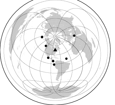
Nearby stations (2 deg radius)

| Station | Name | (Lat, Lon) | Start / End | Elevation |
| PAPL | XB.PAPL | (45.32, -77.81) | 1996-05-22 / 1996-12-31 | 0.0 m |
| Crust2 Type: | H3,early/mid Proter. shield, Finland, 0.5 km seds. |
| Thickness Estimate: | 39 km |
| Thickness StdDev: | 5.9 km |
| Vp/Vs Estimate: | 1.81 |
| Vp/Vs StdDev: | 0.14 |
| Vs Estimate: | 3.644 km/s |
| Poisson's Ratio: | 0.28 |
| Peak Value: | 0.03 |
| Assumed Vp: | 6.577 km/s |
| Ps Weight: | 0.33333334 |
| PpPs Weight: | 0.33333334 |
| PsPs Weight: | 0.33333328 |
| Residual Complexity: | 0.620 |
| Nearby stations H: | +- |
| (2.0 deg) Vp/Vs: | +- |
5 with match > 90% ( 22.727272 %) and 9 with match > 80% ( 40.909092 %) out of 22.
Download stack as xyz text file.
Azimuth Distribution of Events:
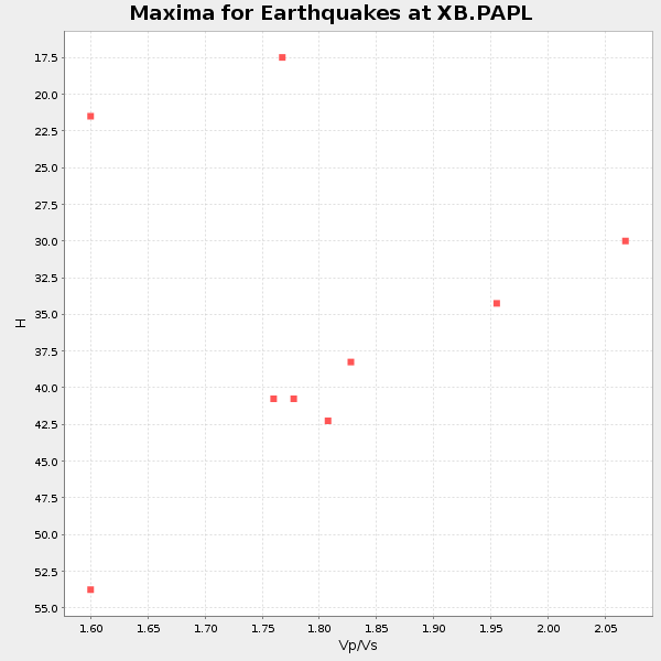
Prior Results for this Station
| Study | Thickness | Vp/Vs | Vp | Vs | Poissons Ratio | Extra |
| EARS | 39 km | 1.81 | 6.577 km/s | 3.644 km/s | 0.28 | |
| Crust2.0 | 46 km | 1.78 | 6.577 km/s | 3.701 km/s | 0.27 | H3,early/mid Proter. shield, Finland, 0.5 km seds. |
| Global Maxima | 39 km | 1.81 | 6.577 km/s | 3.644 km/s | 0.28 | amp=0.027275711 |
| Local Maxima 1 | 29 km | 2.09 | 6.577 km/s | 3.151 km/s | 0.35 | amp=0.025129704 |
| Local Maxima 2 | 41 km | 1.77 | 6.577 km/s | 3.711 km/s | 0.27 | amp=0.012449671 |
| Local Maxima 3 | 52 km | 1.63 | 6.577 km/s | 4.035 km/s | 0.20 | amp=0.011674452 |
| Local Maxima 4 | 28 km | 2.10 | 6.577 km/s | 3.136 km/s | 0.35 | amp=0.0077486285 |
| Predicted Arrivals for vertical incidence (zero ray parameter) | |
| Ps | 4.80 SECOND |
| PpPs | 16.74 SECOND |
| PsPs/PpSs | 21.54 SECOND |
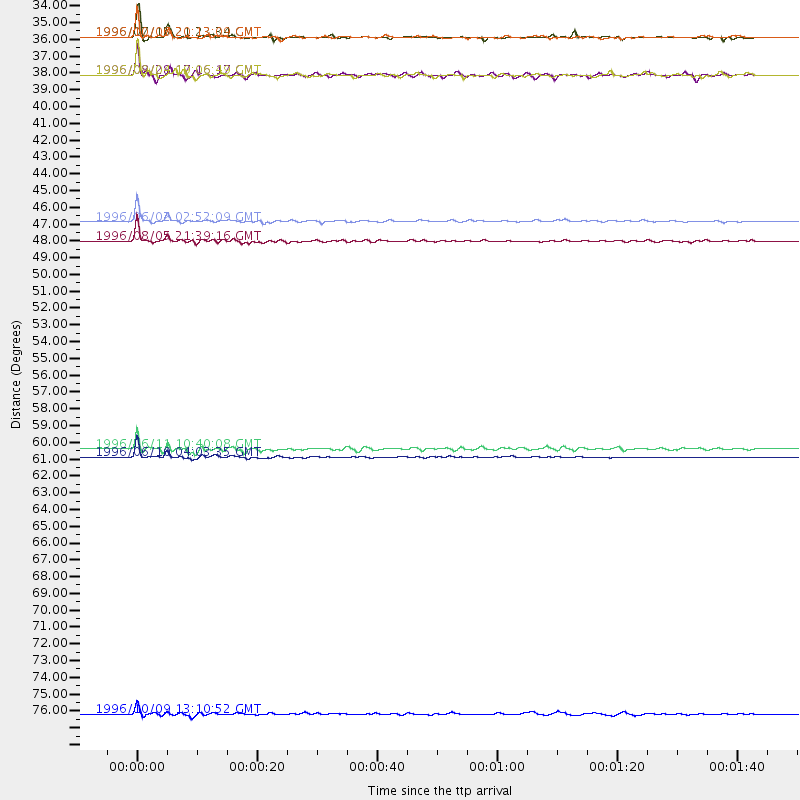
Events Processed for this Station
Download zip of receiver functions as SAC
Plot maxima for each earthquake.
Events Used in the Stack
(9 events)| Radial Match | Distance | Baz | FERegion | Time | Lat/Lon | Depth | Magnitude |
| 98.48944 | 61.4 deg | 315.537 deg | Andreanof Islands, Aleutian Is. | 1996/06/10 04:03:35 GMT | (51.6, -177.6) | 33 km | 6.6 MB, 7.6 MS, 7.9 UNKNOWN, 7.4 MS |
| 96.47149 | 47.2 deg | 184.35 deg | Off Coast Of Ecuador | 1996/08/05 21:39:16 GMT | (-2.0, -81.0) | 33 km | 5.7 MB, 5.9 MS, 6.2 UNKNOWN, 6.2 MW |
| 95.89024 | 45.9 deg | 127.295 deg | Northern Mid-Atlantic Ridge | 1996/06/02 02:52:09 GMT | (10.8, -42.3) | 10 km | 6.1 MB, 6.9 MS, 7.0 UNKNOWN, 6.8 MW |
| 92.96768 | 33.7 deg | 294.699 deg | Vancouver Island, Canada Region | 1996/10/06 20:13:09 GMT | (49.0, -127.9) | 10 km | 5.8 MB, 6.3 MS, 6.2 UNKNOWN, 6.2 MW |
| 92.3245 | 33.7 deg | 222.492 deg | Guerrero, Mexico | 1996/07/15 21:23:34 GMT | (17.6, -101.0) | 18 km | 5.7 MB, 6.5 MS, 6.6 UNKNOWN, 6.2 ME |
| 84.2582 | 60.9 deg | 314.678 deg | Andreanof Islands, Aleutian Is. | 1996/06/11 10:40:08 GMT | (51.3, -176.3) | 33 km | 5.6 MB, 5.6 MS, 6.0 UNKNOWN, 5.5 MS |
| 82.3413 | 36.3 deg | 190.817 deg | Costa Rica | 1996/09/04 19:06:49 GMT | (9.4, -84.3) | 33 km | 5.8 MB, 5.9 MS, 6.2 UNKNOWN, 6.1 MW |
| 81.37526 | 78.4 deg | 52.387 deg | Cyprus Region | 1996/10/09 13:10:52 GMT | (34.6, 32.1) | 33 km | 6.4 MB, 6.8 MS, 7.2 UNKNOWN, 6.8 MW |
| 80.13304 | 36.2 deg | 190.898 deg | Costa Rica | 1996/08/28 17:16:17 GMT | (9.4, -84.3) | 33 km | 5.5 MB, 5.5 MS, 5.9 UNKNOWN |
Losers
(13 events)| Radial Match | Distance | Baz | FERegion | Time | Lat/Lon | Depth | Magnitude | Reason |
| 79.6679 | 61.8 deg | 315.756 deg | Andreanof Islands, Aleutian Is. | 1996/08/19 04:19:16 GMT | (51.5, -178.4) | 33 km | 5.7 MB, 5.6 MS, 6.0 UNKNOWN, 5.7 ML | |
| 78.13406 | 77.1 deg | 174.549 deg | Near Coast Of Central Chile | 1996/09/09 00:20:39 GMT | (-31.9, -71.6) | 39 km | 6.0 MB, 5.5 MS, 6.0 UNKNOWN, 5.8 ME | |
| 73.122284 | 92.2 deg | 329.276 deg | Near East Coast Of Honshu, Japan | 1996/09/11 02:37:14 GMT | (35.5, 140.9) | 55 km | 6.1 MB, 5.7 MS, 6.2 UNKNOWN, 6.1 MW | |
| 72.47404 | 57.8 deg | 313.389 deg | Fox Islands, Aleutian Islands | 1996/07/10 05:48:19 GMT | (52.2, -171.1) | 33 km | 5.9 ML, 5.4 MS, 5.3 MB | |
| 69.98595 | 34.4 deg | 193.379 deg | Nicaragua | 1996/09/18 17:34:20 GMT | (11.4, -85.5) | 193 km | 5.7 UNKNOWN, 5.3 MB, 5.5 MW | |
| 68.2571 | 61.8 deg | 315.661 deg | Andreanof Islands, Aleutian Is. | 1996/06/12 02:16:48 GMT | (51.4, -178.2) | 33 km | 5.5 MB, 5.3 MS, 5.7 UNKNOWN, 5.6 ML | |
| 67.805244 | 80.0 deg | 327.168 deg | Kuril Islands | 1996/10/02 11:24:48 GMT | (45.1, 151.2) | 33 km | 6.1 MB, 5.4 MS, 6.0 UNKNOWN, 6.0 MW | |
| 66.14648 | 89.3 deg | 331.053 deg | Eastern Honshu, Japan | 1996/08/10 18:12:17 GMT | (38.9, 140.5) | 10 km | 6.0 MB, 5.7 MS, 5.9 UNKNOWN, 5.9 MW | |
| 64.85461 | 51.3 deg | 329.892 deg | Near N. Coast Of Eastern Siberia | 1996/10/24 19:31:53 GMT | (67.0, -173.2) | 20 km | 6.0 MB, 5.9 MS, 6.1 UNKNOWN, 5.8 ME | |
| 62.874905 | 92.6 deg | 10.086 deg | Southern Xinjiang, China | 1996/06/08 02:55:57 GMT | (41.7, 88.7) | 0.0 km | 5.9 MB, 4.3 MS | |
| 59.649826 | 71.7 deg | 326.365 deg | Off East Coast Of Kamchatka | 1996/07/18 22:55:03 GMT | (51.5, 159.4) | 33 km | 5.5 MB, 5.2 MS | |
| 57.53976 | 73.9 deg | 331.034 deg | Sea Of Okhotsk | 1996/08/30 21:13:41 GMT | (52.3, 151.5) | 580 km | 5.5 UNKNOWN, 5.1 MB, 5.4 MW | |
| 50.10708 | 33.1 deg | 150.082 deg | Leeward Islands | 1996/09/24 11:42:18 GMT | (15.2, -61.4) | 147 km | 6.0 MB, 5.9 UNKNOWN, 5.7 MW |
