
Station XB POP3 - XB.POP3
Network: XB96 - Abitibi Experiment
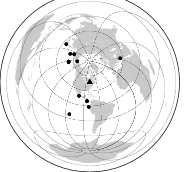
Nearby stations (2 deg radius)
| Station | Name | (Lat, Lon) | Start / End | Elevation |
| POP3 | XB.POP3 | (47.45, -79.18) | 1996-05-19 / 1996-12-31 | 0.0 m |
| Crust2 Type: | H2,early/mid Proter. shield, Finland, no seds. |
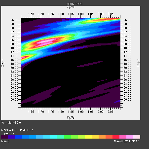
| Thickness Estimate: | 36 km |
| Thickness StdDev: | 6.6 km |
| Vp/Vs Estimate: | 1.72 |
| Vp/Vs StdDev: | 0.15 |
| Vs Estimate: | 3.85 km/s |
| Poisson's Ratio: | 0.24 |
| Peak Value: | 0.02 |
| Assumed Vp: | 6.622 km/s |
| Ps Weight: | 0.33333334 |
| PpPs Weight: | 0.33333334 |
| PsPs Weight: | 0.33333328 |
| Residual Complexity: | 0.676 |
| Nearby stations H: | +- |
| (2.0 deg) Vp/Vs: | +- |
6 with match > 90% ( 24.0 %) and 13 with match > 80% ( 52.0 %) out of 25.
Download stack as xyz text file.
Azimuth Distribution of Events:
Prior Results for this Station
| Study | Thickness | Vp/Vs | Vp | Vs | Poissons Ratio | Extra |
| EARS | 36 km | 1.72 | 6.622 km/s | 3.85 km/s | 0.24 | |
| Crust2.0 | 45 km | 1.78 | 6.622 km/s | 3.729 km/s | 0.27 | H2,early/mid Proter. shield, Finland, no seds. |
| Global Maxima | 36 km | 1.72 | 6.622 km/s | 3.85 km/s | 0.24 | amp=0.021193147 |
| Local Maxima 1 | 45 km | 1.60 | 6.622 km/s | 4.139 km/s | 0.18 | amp=0.01918244 |
| Local Maxima 2 | 25 km | 2.04 | 6.622 km/s | 3.254 km/s | 0.34 | amp=0.016153758 |
| Local Maxima 3 | 38 km | 1.72 | 6.622 km/s | 3.861 km/s | 0.24 | amp=0.014447804 |
| Local Maxima 4 | 34 km | 1.83 | 6.622 km/s | 3.619 km/s | 0.29 | amp=0.007147446 |
| Predicted Arrivals for vertical incidence (zero ray parameter) | |
| Ps | 3.97 SECOND |
| PpPs | 14.99 SECOND |
| PsPs/PpSs | 18.96 SECOND |
Events Processed for this Station
Download zip of receiver functions as SAC
Plot maxima for each earthquake.
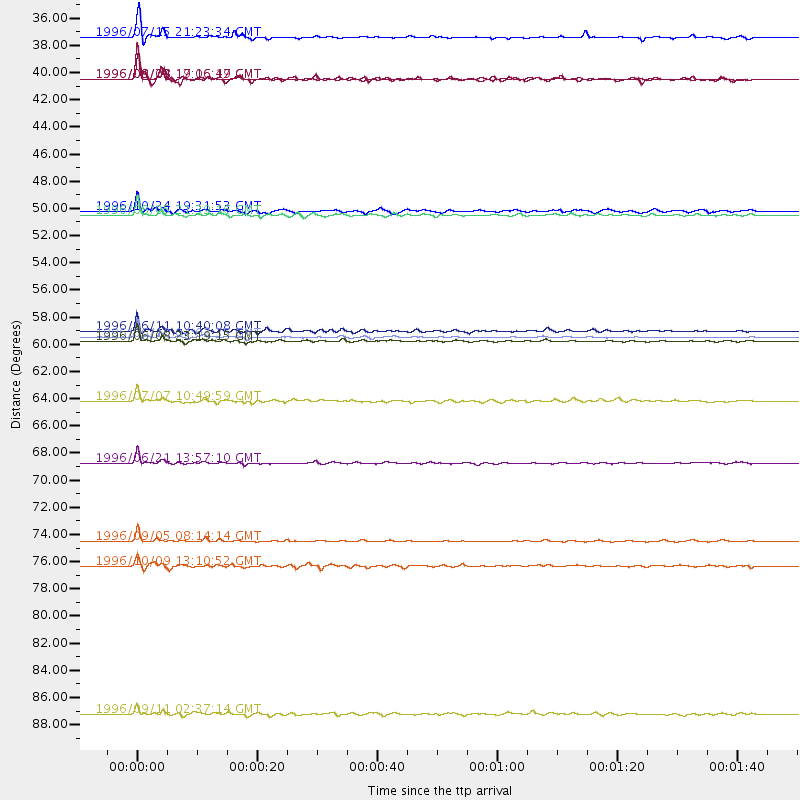
Events Used in the Stack
(13 events)| Radial Match | Distance | Baz | FERegion | Time | Lat/Lon | Depth | Magnitude |
| 97.68255 | 59.2 deg | 314.064 deg | Andreanof Islands, Aleutian Is. | 1996/06/10 04:03:35 GMT | (51.6, -177.6) | 33 km | 6.6 MB, 7.6 MS, 7.9 UNKNOWN, 7.4 MS |
| 96.217514 | 69.4 deg | 325.447 deg | Off East Coast Of Kamchatka | 1996/06/21 13:57:10 GMT | (51.6, 159.1) | 20 km | 6.0 MB, 6.6 MS, 7.0 UNKNOWN, 6.5 MS |
| 94.08159 | 49.3 deg | 182.402 deg | Off Coast Of Ecuador | 1996/08/05 21:39:16 GMT | (-2.0, -81.0) | 33 km | 5.7 MB, 5.9 MS, 6.2 UNKNOWN, 6.2 MW |
| 93.141655 | 59.5 deg | 314.224 deg | Andreanof Islands, Aleutian Is. | 1996/06/08 23:19:15 GMT | (51.5, -178.1) | 33 km | 5.9 MB, 6.3 MS, 6.5 UNKNOWN, 6.1 MS |
| 92.519455 | 75.8 deg | 212.574 deg | Easter Island Region | 1996/09/05 08:14:14 GMT | (-22.1, -113.4) | 10 km | 6.2 MB, 7.0 MS, 7.0 UNKNOWN, 6.9 MW |
| 90.595245 | 49.0 deg | 328.673 deg | Near N. Coast Of Eastern Siberia | 1996/10/24 19:31:53 GMT | (67.0, -173.2) | 20 km | 6.0 MB, 5.9 MS, 6.1 UNKNOWN, 5.8 ME |
| 89.80413 | 34.7 deg | 218.403 deg | Guerrero, Mexico | 1996/07/15 21:23:34 GMT | (17.6, -101.0) | 18 km | 5.7 MB, 6.5 MS, 6.6 UNKNOWN, 6.2 ME |
| 88.24125 | 38.2 deg | 188.132 deg | Costa Rica | 1996/09/04 19:06:49 GMT | (9.4, -84.3) | 33 km | 5.8 MB, 5.9 MS, 6.2 UNKNOWN, 6.1 MW |
| 85.24311 | 38.2 deg | 188.209 deg | Costa Rica | 1996/08/28 17:16:17 GMT | (9.4, -84.3) | 33 km | 5.5 MB, 5.5 MS, 5.9 UNKNOWN |
| 82.03943 | 64.4 deg | 330.905 deg | Kamchatka Peninsula, Russia | 1996/07/07 10:49:59 GMT | (58.6, 157.8) | 10 km | 5.6 MB, 5.6 MS, 5.8 UNKNOWN, 5.8 MW |
| 80.89555 | 58.7 deg | 313.177 deg | Andreanof Islands, Aleutian Is. | 1996/06/11 10:40:08 GMT | (51.3, -176.3) | 33 km | 5.6 MB, 5.6 MS, 6.0 UNKNOWN, 5.5 MS |
| 80.804405 | 89.9 deg | 328.292 deg | Near East Coast Of Honshu, Japan | 1996/09/11 02:37:14 GMT | (35.5, 140.9) | 55 km | 6.1 MB, 5.7 MS, 6.2 UNKNOWN, 6.1 MW |
| 80.533516 | 77.8 deg | 51.876 deg | Cyprus Region | 1996/10/09 13:10:52 GMT | (34.6, 32.1) | 33 km | 6.4 MB, 6.8 MS, 7.2 UNKNOWN, 6.8 MW |
Losers
(12 events)| Radial Match | Distance | Baz | FERegion | Time | Lat/Lon | Depth | Magnitude | Reason |
| 79.55918 | 32.0 deg | 291.239 deg | Vancouver Island, Canada Region | 1996/10/06 20:13:09 GMT | (49.0, -127.9) | 10 km | 5.8 MB, 6.3 MS, 6.2 UNKNOWN, 6.2 MW | |
| 75.58759 | 79.3 deg | 173.409 deg | Near Coast Of Central Chile | 1996/09/09 00:20:39 GMT | (-31.9, -71.6) | 39 km | 6.0 MB, 5.5 MS, 6.0 UNKNOWN, 5.8 ME | |
| 74.61505 | 69.4 deg | 325.229 deg | Off East Coast Of Kamchatka | 1996/07/18 22:55:03 GMT | (51.5, 159.4) | 33 km | 5.5 MB, 5.2 MS | |
| 71.691086 | 59.7 deg | 314.297 deg | Andreanof Islands, Aleutian Is. | 1996/08/19 04:19:16 GMT | (51.5, -178.4) | 33 km | 5.7 MB, 5.6 MS, 6.0 UNKNOWN, 5.7 ML | |
| 69.70253 | 70.9 deg | 171.471 deg | Near Coast Of Northern Chile | 1996/07/03 16:48:27 GMT | (-23.4, -70.4) | 33 km | 5.3 MB, 5.4 MS, 5.8 UNKNOWN | |
| 68.97079 | 55.6 deg | 311.789 deg | Fox Islands, Aleutian Islands | 1996/07/10 05:48:19 GMT | (52.2, -171.1) | 33 km | 5.9 ML, 5.4 MS, 5.3 MB | |
| 63.233936 | 35.4 deg | 149.468 deg | Leeward Islands | 1996/09/24 11:42:18 GMT | (15.2, -61.4) | 147 km | 6.0 MB, 5.9 UNKNOWN, 5.7 MW | |
| 62.27595 | 87.0 deg | 330.056 deg | Eastern Honshu, Japan | 1996/08/10 18:12:17 GMT | (38.9, 140.5) | 10 km | 6.0 MB, 5.7 MS, 5.9 UNKNOWN, 5.9 MW | |
| 61.86672 | 55.1 deg | 350.369 deg | Laptev Sea | 1996/06/22 16:47:12 GMT | (75.8, 134.6) | 10 km | 5.6 MB, 5.5 MS, 5.8 UNKNOWN, 5.7 MW | |
| 60.207363 | 59.6 deg | 314.199 deg | Andreanof Islands, Aleutian Is. | 1996/06/12 02:16:48 GMT | (51.4, -178.2) | 33 km | 5.5 MB, 5.3 MS, 5.7 UNKNOWN, 5.6 ML | |
| 59.132603 | 77.7 deg | 326.103 deg | Kuril Islands | 1996/10/02 11:24:48 GMT | (45.1, 151.2) | 33 km | 6.1 MB, 5.4 MS, 6.0 UNKNOWN, 6.0 MW | |
| 47.182106 | 71.6 deg | 329.975 deg | Sea Of Okhotsk | 1996/08/30 21:13:41 GMT | (52.3, 151.5) | 580 km | 5.5 UNKNOWN, 5.1 MB, 5.4 MW |
