
Station XB POP4 - XB.POP4
Network: XB96 - Abitibi Experiment
Nearby stations (2 deg radius)
| Station | Name | (Lat, Lon) | Start / End | Elevation |
| POP4 | XB.POP4 | (47.26, -79.12) | 1996-05-19 / 1996-12-31 | 0.0 m |
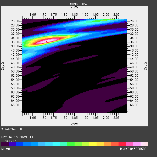
| Crust2 Type: | H2,early/mid Proter. shield, Finland, no seds. |
| Thickness Estimate: | 36 km |
| Thickness StdDev: | 1.8 km |
| Vp/Vs Estimate: | 1.72 |
| Vp/Vs StdDev: | 0.06 |
| Vs Estimate: | 3.861 km/s |
| Poisson's Ratio: | 0.24 |
| Peak Value: | 0.05 |
| Assumed Vp: | 6.622 km/s |
| Ps Weight: | 0.33333334 |
| PpPs Weight: | 0.33333334 |
| PsPs Weight: | 0.33333328 |
| Residual Complexity: | 0.536 |
| Nearby stations H: | +- |
| (2.0 deg) Vp/Vs: | +- |
5 with match > 90% ( 19.23077 %) and 10 with match > 80% ( 38.46154 %) out of 26.
Download stack as xyz text file.
Azimuth Distribution of Events:

Prior Results for this Station
| Study | Thickness | Vp/Vs | Vp | Vs | Poissons Ratio | Extra |
| EARS | 36 km | 1.72 | 6.622 km/s | 3.861 km/s | 0.24 | |
| Crust2.0 | 45 km | 1.78 | 6.622 km/s | 3.729 km/s | 0.27 | H2,early/mid Proter. shield, Finland, no seds. |
| Global Maxima | 36 km | 1.72 | 6.622 km/s | 3.861 km/s | 0.24 | amp=0.045800503 |
| Local Maxima 1 | 34 km | 1.73 | 6.622 km/s | 3.828 km/s | 0.25 | amp=0.024823198 |
| Local Maxima 2 | 25 km | 2.01 | 6.622 km/s | 3.299 km/s | 0.33 | amp=0.02171304 |
| Local Maxima 3 | 34 km | 1.68 | 6.622 km/s | 3.954 km/s | 0.22 | amp=0.013317558 |
| Local Maxima 4 | 43 km | 1.61 | 6.622 km/s | 4.113 km/s | 0.19 | amp=0.011885578 |
| Predicted Arrivals for vertical incidence (zero ray parameter) | |
| Ps | 3.83 SECOND |
| PpPs | 14.55 SECOND |
| PsPs/PpSs | 18.39 SECOND |
Events Processed for this Station
Download zip of receiver functions as SAC
Plot maxima for each earthquake.
Events Used in the Stack
(10 events)| Radial Match | Distance | Baz | FERegion | Time | Lat/Lon | Depth | Magnitude |
| 97.002205 | 59.1 deg | 313.744 deg | Andreanof Islands, Aleutian Is. | 1996/06/10 15:24:56 GMT | (51.5, -176.8) | 26 km | 5.9 MB, 7.1 MS, 7.2 UNKNOWN, 6.9 MS |
| 95.05385 | 69.6 deg | 325.521 deg | Off East Coast Of Kamchatka | 1996/06/21 13:57:10 GMT | (51.6, 159.1) | 20 km | 6.0 MB, 6.6 MS, 7.0 UNKNOWN, 6.5 MS |
| 92.49169 | 49.1 deg | 182.489 deg | Off Coast Of Ecuador | 1996/08/05 21:39:16 GMT | (-2.0, -81.0) | 33 km | 5.7 MB, 5.9 MS, 6.2 UNKNOWN, 6.2 MW |
| 92.25105 | 75.7 deg | 212.655 deg | Easter Island Region | 1996/09/05 08:14:14 GMT | (-22.1, -113.4) | 10 km | 6.2 MB, 7.0 MS, 7.0 UNKNOWN, 6.9 MW |
| 90.2609 | 34.6 deg | 218.674 deg | Guerrero, Mexico | 1996/07/15 21:23:34 GMT | (17.6, -101.0) | 18 km | 5.7 MB, 6.5 MS, 6.6 UNKNOWN, 6.2 ME |
| 89.95494 | 38.0 deg | 188.265 deg | Costa Rica | 1996/09/04 19:06:49 GMT | (9.4, -84.3) | 33 km | 5.8 MB, 5.9 MS, 6.2 UNKNOWN, 6.1 MW |
| 86.54301 | 32.1 deg | 291.555 deg | Vancouver Island, Canada Region | 1996/10/06 20:13:09 GMT | (49.0, -127.9) | 10 km | 5.8 MB, 6.3 MS, 6.2 UNKNOWN, 6.2 MW |
| 85.609604 | 38.0 deg | 188.342 deg | Costa Rica | 1996/08/28 17:16:17 GMT | (9.4, -84.3) | 33 km | 5.5 MB, 5.5 MS, 5.9 UNKNOWN |
| 81.31054 | 49.2 deg | 328.776 deg | Near N. Coast Of Eastern Siberia | 1996/10/24 19:31:53 GMT | (67.0, -173.2) | 20 km | 6.0 MB, 5.9 MS, 6.1 UNKNOWN, 5.8 ME |
| 80.38473 | 77.9 deg | 51.882 deg | Cyprus Region | 1996/10/09 13:10:52 GMT | (34.6, 32.1) | 33 km | 6.4 MB, 6.8 MS, 7.2 UNKNOWN, 6.8 MW |
Losers
(16 events)| Radial Match | Distance | Baz | FERegion | Time | Lat/Lon | Depth | Magnitude | Reason |
| 93.5782 | 87.2 deg | 330.097 deg | Eastern Honshu, Japan | 1996/08/10 18:54:11 GMT | (38.9, 140.6) | 10 km | 5.7 MB, 5.1 MS | |
| 79.500916 | 63.9 deg | 325.841 deg | Komandorskiye Ostrova Region | 1996/07/16 03:48:28 GMT | (56.1, 165.0) | 33 km | 5.8 MB, 6.4 MS, 6.5 UNKNOWN, 6.3 MW | |
| 77.07972 | 70.7 deg | 171.519 deg | Near Coast Of Northern Chile | 1996/07/03 16:48:27 GMT | (-23.4, -70.4) | 33 km | 5.3 MB, 5.4 MS, 5.8 UNKNOWN | |
| 74.55842 | 64.6 deg | 330.979 deg | Kamchatka Peninsula, Russia | 1996/07/07 10:49:59 GMT | (58.6, 157.8) | 10 km | 5.6 MB, 5.6 MS, 5.8 UNKNOWN, 5.8 MW | |
| 73.67496 | 59.8 deg | 314.407 deg | Andreanof Islands, Aleutian Is. | 1996/08/19 04:19:16 GMT | (51.5, -178.4) | 33 km | 5.7 MB, 5.6 MS, 6.0 UNKNOWN, 5.7 ML | |
| 72.36776 | 58.9 deg | 313.292 deg | Andreanof Islands, Aleutian Is. | 1996/06/11 10:40:08 GMT | (51.3, -176.3) | 33 km | 5.6 MB, 5.6 MS, 6.0 UNKNOWN, 5.5 MS | |
| 70.93058 | 69.7 deg | 325.346 deg | Off East Coast Of Kamchatka | 1996/06/22 14:50:07 GMT | (51.4, 159.2) | 33 km | 5.6 MB, 6.0 MS, 6.2 UNKNOWN, 6.2 MW | |
| 70.36819 | 59.8 deg | 314.31 deg | Andreanof Islands, Aleutian Is. | 1996/06/12 02:16:48 GMT | (51.4, -178.2) | 33 km | 5.5 MB, 5.3 MS, 5.7 UNKNOWN, 5.6 ML | |
| 59.833668 | 55.8 deg | 311.916 deg | Fox Islands, Aleutian Islands | 1996/07/10 05:48:19 GMT | (52.2, -171.1) | 33 km | 5.9 ML, 5.4 MS, 5.3 MB | |
| 59.677464 | 87.2 deg | 330.104 deg | Eastern Honshu, Japan | 1996/08/10 18:12:17 GMT | (38.9, 140.5) | 10 km | 6.0 MB, 5.7 MS, 5.9 UNKNOWN, 5.9 MW | |
| 59.098923 | 77.9 deg | 326.164 deg | Kuril Islands | 1996/10/02 11:24:48 GMT | (45.1, 151.2) | 33 km | 6.1 MB, 5.4 MS, 6.0 UNKNOWN, 6.0 MW | |
| 55.767902 | 90.8 deg | 9.105 deg | Southern Xinjiang, China | 1996/06/08 02:55:57 GMT | (41.7, 88.7) | 0.0 km | 5.9 MB, 4.3 MS | |
| 55.081867 | 69.6 deg | 325.303 deg | Off East Coast Of Kamchatka | 1996/07/18 22:55:03 GMT | (51.5, 159.4) | 33 km | 5.5 MB, 5.2 MS | |
| 53.227165 | 93.0 deg | 330.204 deg | Near S. Coast Of Honshu, Japan | 1996/10/18 16:44:47 GMT | (33.7, 137.4) | 338 km | 5.6 UNKNOWN, 5.4 MB, 5.6 MW | |
| 52.026787 | 74.8 deg | 45.766 deg | Turkey | 1996/08/14 01:55:02 GMT | (40.8, 35.3) | 10 km | 5.6 MS, 5.3 MB, 5.8 UNKNOWN, 5.7 MW | |
| 43.076004 | 71.8 deg | 330.04 deg | Sea Of Okhotsk | 1996/08/30 21:13:41 GMT | (52.3, 151.5) | 580 km | 5.5 UNKNOWN, 5.1 MB, 5.4 MW |
