
Station XB POP5 - XB.POP5
Network: XB96 - Abitibi Experiment
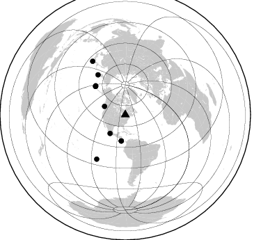
Nearby stations (2 deg radius)
| Station | Name | (Lat, Lon) | Start / End | Elevation |
| POP5 | XB.POP5 | (47.12, -78.91) | 1996-05-19 / 1996-12-31 | 0.0 m |
| Crust2 Type: | H2,early/mid Proter. shield, Finland, no seds. |
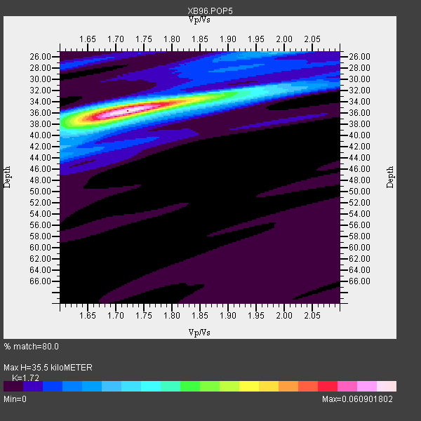
| Thickness Estimate: | 36 km |
| Thickness StdDev: | 1.4 km |
| Vp/Vs Estimate: | 1.72 |
| Vp/Vs StdDev: | 0.03 |
| Vs Estimate: | 3.85 km/s |
| Poisson's Ratio: | 0.24 |
| Peak Value: | 0.06 |
| Assumed Vp: | 6.622 km/s |
| Ps Weight: | 0.33333334 |
| PpPs Weight: | 0.33333334 |
| PsPs Weight: | 0.33333328 |
| Residual Complexity: | 0.394 |
| Nearby stations H: | +- |
| (2.0 deg) Vp/Vs: | +- |
4 with match > 90% ( 19.047619 %) and 10 with match > 80% ( 47.61905 %) out of 21.
Download stack as xyz text file.
Azimuth Distribution of Events:
Prior Results for this Station
| Study | Thickness | Vp/Vs | Vp | Vs | Poissons Ratio | Extra |
| EARS | 36 km | 1.72 | 6.622 km/s | 3.85 km/s | 0.24 | |
| Crust2.0 | 45 km | 1.78 | 6.622 km/s | 3.729 km/s | 0.27 | H2,early/mid Proter. shield, Finland, no seds. |
| Global Maxima | 36 km | 1.72 | 6.622 km/s | 3.85 km/s | 0.24 | amp=0.060901802 |
| Local Maxima 1 | 35 km | 1.70 | 6.622 km/s | 3.901 km/s | 0.23 | amp=0.021413444 |
| Local Maxima 2 | 25 km | 1.97 | 6.622 km/s | 3.366 km/s | 0.33 | amp=0.014956873 |
| Local Maxima 3 | 38 km | 1.65 | 6.622 km/s | 4.007 km/s | 0.21 | amp=0.013723995 |
| Local Maxima 4 | 32 km | 1.92 | 6.622 km/s | 3.445 km/s | 0.31 | amp=0.011036993 |
| Predicted Arrivals for vertical incidence (zero ray parameter) | |
| Ps | 3.86 SECOND |
| PpPs | 14.58 SECOND |
| PsPs/PpSs | 18.44 SECOND |
Events Processed for this Station
Download zip of receiver functions as SAC
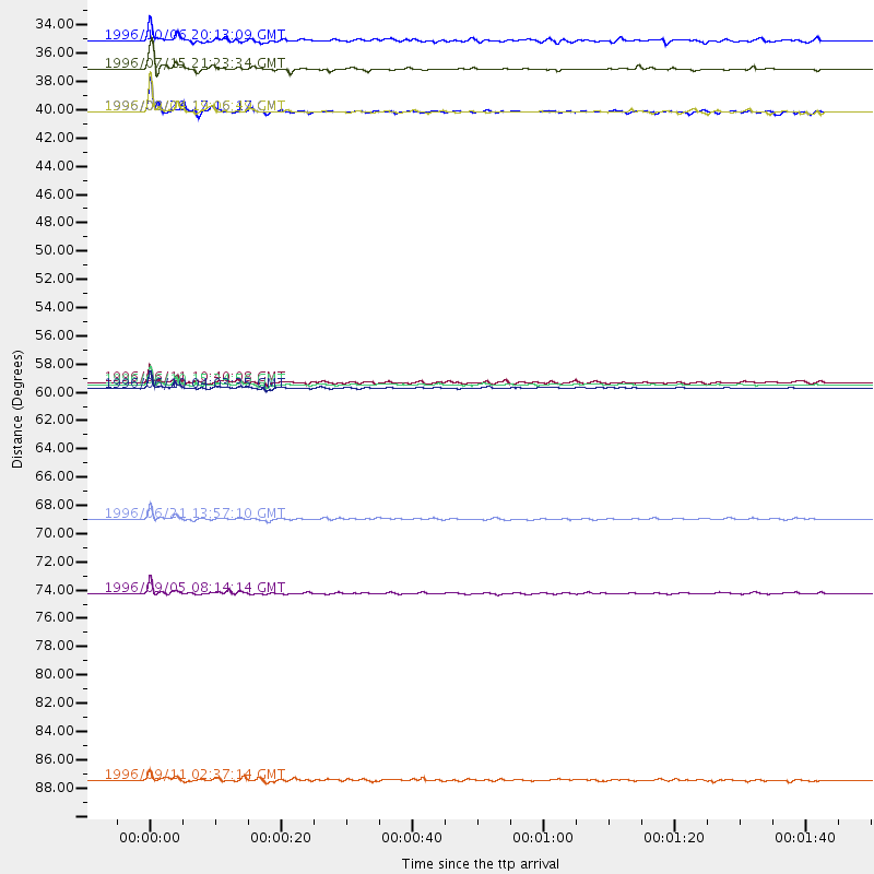
Plot maxima for each earthquake.
Events Used in the Stack
(10 events)| Radial Match | Distance | Baz | FERegion | Time | Lat/Lon | Depth | Magnitude |
| 98.89246 | 59.3 deg | 313.898 deg | Andreanof Islands, Aleutian Is. | 1996/06/10 15:24:56 GMT | (51.5, -176.8) | 26 km | 5.9 MB, 7.1 MS, 7.2 UNKNOWN, 6.9 MS |
| 98.37409 | 59.6 deg | 314.33 deg | Andreanof Islands, Aleutian Is. | 1996/06/10 04:03:35 GMT | (51.6, -177.6) | 33 km | 6.6 MB, 7.6 MS, 7.9 UNKNOWN, 7.4 MS |
| 94.64537 | 75.6 deg | 212.86 deg | Easter Island Region | 1996/09/05 08:14:14 GMT | (-22.1, -113.4) | 10 km | 6.2 MB, 7.0 MS, 7.0 UNKNOWN, 6.9 MW |
| 90.74607 | 34.6 deg | 219.117 deg | Guerrero, Mexico | 1996/07/15 21:23:34 GMT | (17.6, -101.0) | 18 km | 5.7 MB, 6.5 MS, 6.6 UNKNOWN, 6.2 ME |
| 89.56009 | 32.3 deg | 291.827 deg | Vancouver Island, Canada Region | 1996/10/06 20:13:09 GMT | (49.0, -127.9) | 10 km | 5.8 MB, 6.3 MS, 6.2 UNKNOWN, 6.2 MW |
| 89.18071 | 37.9 deg | 188.629 deg | Costa Rica | 1996/09/04 19:06:49 GMT | (9.4, -84.3) | 33 km | 5.8 MB, 5.9 MS, 6.2 UNKNOWN, 6.1 MW |
| 87.12563 | 69.8 deg | 325.661 deg | Off East Coast Of Kamchatka | 1996/06/21 13:57:10 GMT | (51.6, 159.1) | 20 km | 6.0 MB, 6.6 MS, 7.0 UNKNOWN, 6.5 MS |
| 85.072655 | 37.9 deg | 188.707 deg | Costa Rica | 1996/08/28 17:16:17 GMT | (9.4, -84.3) | 33 km | 5.5 MB, 5.5 MS, 5.9 UNKNOWN |
| 85.039925 | 90.3 deg | 328.492 deg | Near East Coast Of Honshu, Japan | 1996/09/11 02:37:14 GMT | (35.5, 140.9) | 55 km | 6.1 MB, 5.7 MS, 6.2 UNKNOWN, 6.1 MW |
| 84.58617 | 59.1 deg | 313.447 deg | Andreanof Islands, Aleutian Is. | 1996/06/11 10:40:08 GMT | (51.3, -176.3) | 33 km | 5.6 MB, 5.6 MS, 6.0 UNKNOWN, 5.5 MS |
Losers
(11 events)| Radial Match | Distance | Baz | FERegion | Time | Lat/Lon | Depth | Magnitude | Reason |
| 93.95297 | 74.8 deg | 45.868 deg | Turkey | 1996/08/14 01:55:02 GMT | (40.8, 35.3) | 10 km | 5.6 MS, 5.3 MB, 5.8 UNKNOWN, 5.7 MW | |
| 79.335526 | 78.9 deg | 173.637 deg | Near Coast Of Central Chile | 1996/09/09 00:20:39 GMT | (-31.9, -71.6) | 39 km | 6.0 MB, 5.5 MS, 6.0 UNKNOWN, 5.8 ME | |
| 78.72497 | 64.8 deg | 331.105 deg | Kamchatka Peninsula, Russia | 1996/07/07 10:49:59 GMT | (58.6, 157.8) | 10 km | 5.6 MB, 5.6 MS, 5.8 UNKNOWN, 5.8 MW | |
| 78.42073 | 77.9 deg | 51.995 deg | Cyprus Region | 1996/10/09 13:10:52 GMT | (34.6, 32.1) | 33 km | 6.4 MB, 6.8 MS, 7.2 UNKNOWN, 6.8 MW | |
| 72.57311 | 87.4 deg | 330.256 deg | Eastern Honshu, Japan | 1996/08/10 18:12:17 GMT | (38.9, 140.5) | 10 km | 6.0 MB, 5.7 MS, 5.9 UNKNOWN, 5.9 MW | |
| 66.744606 | 70.6 deg | 171.718 deg | Near Coast Of Northern Chile | 1996/07/03 16:48:27 GMT | (-23.4, -70.4) | 33 km | 5.3 MB, 5.4 MS, 5.8 UNKNOWN | |
| 65.092514 | 69.9 deg | 325.486 deg | Off East Coast Of Kamchatka | 1996/06/22 14:50:07 GMT | (51.4, 159.2) | 33 km | 5.6 MB, 6.0 MS, 6.2 UNKNOWN, 6.2 MW | |
| 60.422916 | 78.1 deg | 326.31 deg | Kuril Islands | 1996/10/02 11:24:48 GMT | (45.1, 151.2) | 33 km | 6.1 MB, 5.4 MS, 6.0 UNKNOWN, 6.0 MW | |
| 59.484116 | 36.0 deg | 190.993 deg | Nicaragua | 1996/09/18 17:34:20 GMT | (11.4, -85.5) | 193 km | 5.7 UNKNOWN, 5.3 MB, 5.5 MW | |
| 57.29517 | 60.0 deg | 314.463 deg | Andreanof Islands, Aleutian Is. | 1996/06/12 02:16:48 GMT | (51.4, -178.2) | 33 km | 5.5 MB, 5.3 MS, 5.7 UNKNOWN, 5.6 ML | |
| 54.88712 | 72.0 deg | 330.177 deg | Sea Of Okhotsk | 1996/08/30 21:13:41 GMT | (52.3, 151.5) | 580 km | 5.5 UNKNOWN, 5.1 MB, 5.4 MW |
