
Station XB POUL - XB.POUL
Network: XB96 - Abitibi Experiment
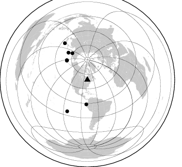
Nearby stations (2 deg radius)
| Station | Name | (Lat, Lon) | Start / End | Elevation |
| POUL | XB.POUL | (48.63, -79.04) | 1996-05-20 / 1996-12-31 | 0.0 m |
| Crust2 Type: | H1,early/mid Proter., no seds. |
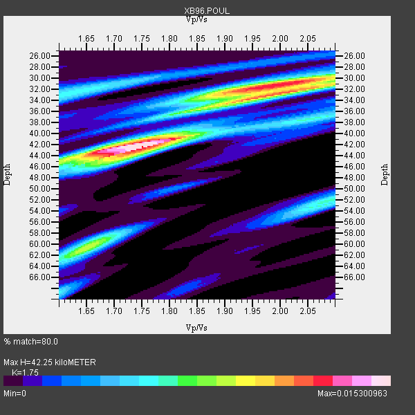
| Thickness Estimate: | 42 km |
| Thickness StdDev: | 6.5 km |
| Vp/Vs Estimate: | 1.75 |
| Vp/Vs StdDev: | 0.13 |
| Vs Estimate: | 3.777 km/s |
| Poisson's Ratio: | 0.26 |
| Peak Value: | 0.02 |
| Assumed Vp: | 6.61 km/s |
| Ps Weight: | 0.33333334 |
| PpPs Weight: | 0.33333334 |
| PsPs Weight: | 0.33333328 |
| Residual Complexity: | 0.768 |
| Nearby stations H: | +- |
| (2.0 deg) Vp/Vs: | +- |
6 with match > 90% ( 26.086956 %) and 8 with match > 80% ( 34.782608 %) out of 23.
Download stack as xyz text file.
Azimuth Distribution of Events:
Prior Results for this Station
| Study | Thickness | Vp/Vs | Vp | Vs | Poissons Ratio | Extra |
| EARS | 42 km | 1.75 | 6.61 km/s | 3.777 km/s | 0.26 | |
| Crust2.0 | 40 km | 1.77 | 6.61 km/s | 3.725 km/s | 0.27 | H1,early/mid Proter., no seds. |
| Global Maxima | 42 km | 1.75 | 6.61 km/s | 3.777 km/s | 0.26 | amp=0.015300963 |
| Local Maxima 1 | 31 km | 1.99 | 6.61 km/s | 3.33 km/s | 0.33 | amp=0.012588063 |
| Local Maxima 2 | 33 km | 2.00 | 6.61 km/s | 3.305 km/s | 0.33 | amp=0.009240843 |
| Local Maxima 3 | 60 km | 1.65 | 6.61 km/s | 4.006 km/s | 0.21 | amp=0.009057791 |
| Local Maxima 4 | 42 km | 1.70 | 6.61 km/s | 3.894 km/s | 0.23 | amp=0.0072628045 |
| Predicted Arrivals for vertical incidence (zero ray parameter) | |
| Ps | 4.79 SECOND |
| PpPs | 17.58 SECOND |
| PsPs/PpSs | 22.37 SECOND |
Events Processed for this Station
Download zip of receiver functions as SAC
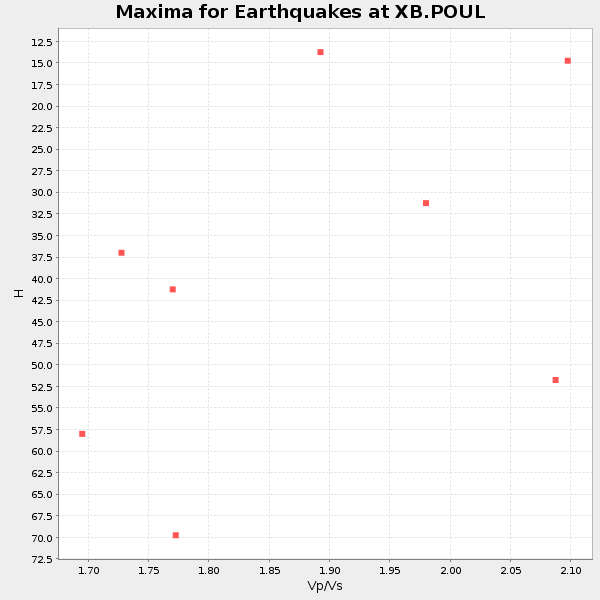
Plot maxima for each earthquake.
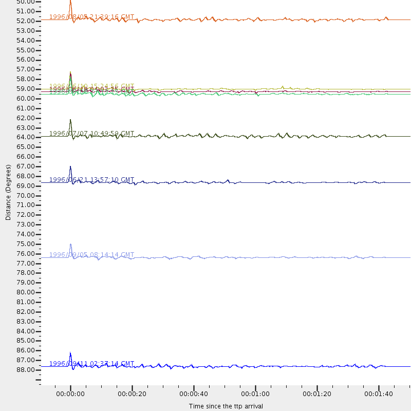
Events Used in the Stack
(8 events)| Radial Match | Distance | Baz | FERegion | Time | Lat/Lon | Depth | Magnitude |
| 98.54818 | 58.2 deg | 313.169 deg | Andreanof Islands, Aleutian Is. | 1996/06/10 15:24:56 GMT | (51.5, -176.8) | 26 km | 5.9 MB, 7.1 MS, 7.2 UNKNOWN, 6.9 MS |
| 98.14332 | 58.5 deg | 313.614 deg | Andreanof Islands, Aleutian Is. | 1996/06/10 04:03:35 GMT | (51.6, -177.6) | 33 km | 6.6 MB, 7.6 MS, 7.9 UNKNOWN, 7.4 MS |
| 96.471146 | 68.5 deg | 325.262 deg | Off East Coast Of Kamchatka | 1996/06/21 13:57:10 GMT | (51.6, 159.1) | 20 km | 6.0 MB, 6.6 MS, 7.0 UNKNOWN, 6.5 MS |
| 94.31972 | 76.9 deg | 212.541 deg | Easter Island Region | 1996/09/05 08:14:14 GMT | (-22.1, -113.4) | 10 km | 6.2 MB, 7.0 MS, 7.0 UNKNOWN, 6.9 MW |
| 92.808945 | 58.8 deg | 313.781 deg | Andreanof Islands, Aleutian Is. | 1996/06/08 23:19:15 GMT | (51.5, -178.1) | 33 km | 5.9 MB, 6.3 MS, 6.5 UNKNOWN, 6.1 MS |
| 91.40818 | 50.5 deg | 182.539 deg | Off Coast Of Ecuador | 1996/08/05 21:39:16 GMT | (-2.0, -81.0) | 33 km | 5.7 MB, 5.9 MS, 6.2 UNKNOWN, 6.2 MW |
| 86.615814 | 63.4 deg | 330.686 deg | Kamchatka Peninsula, Russia | 1996/07/07 10:49:59 GMT | (58.6, 157.8) | 10 km | 5.6 MB, 5.6 MS, 5.8 UNKNOWN, 5.8 MW |
| 85.155846 | 88.9 deg | 328.387 deg | Near East Coast Of Honshu, Japan | 1996/09/11 02:37:14 GMT | (35.5, 140.9) | 55 km | 6.1 MB, 5.7 MS, 6.2 UNKNOWN, 6.1 MW |
Losers
(15 events)| Radial Match | Distance | Baz | FERegion | Time | Lat/Lon | Depth | Magnitude | Reason |
| 79.72335 | 86.0 deg | 330.118 deg | Eastern Honshu, Japan | 1996/08/10 18:12:17 GMT | (38.9, 140.5) | 10 km | 6.0 MB, 5.7 MS, 5.9 UNKNOWN, 5.9 MW | |
| 79.641655 | 80.4 deg | 173.551 deg | Near Coast Of Central Chile | 1996/09/09 00:20:39 GMT | (-31.9, -71.6) | 39 km | 6.0 MB, 5.5 MS, 6.0 UNKNOWN, 5.8 ME | |
| 77.358284 | 39.4 deg | 188.215 deg | Costa Rica | 1996/08/28 17:16:17 GMT | (9.4, -84.3) | 33 km | 5.5 MB, 5.5 MS, 5.9 UNKNOWN | |
| 76.02066 | 58.0 deg | 312.709 deg | Andreanof Islands, Aleutian Is. | 1996/06/11 10:40:08 GMT | (51.3, -176.3) | 33 km | 5.6 MB, 5.6 MS, 6.0 UNKNOWN, 5.5 MS | |
| 73.85024 | 69.8 deg | 329.602 deg | Northwest Of Kuril Islands | 1996/10/08 07:52:58 GMT | (52.9, 152.5) | 627 km | 5.6 UNKNOWN, 5.2 MB | |
| 70.378624 | 76.8 deg | 326.039 deg | Kuril Islands | 1996/10/02 11:24:48 GMT | (45.1, 151.2) | 33 km | 6.1 MB, 5.4 MS, 6.0 UNKNOWN, 6.0 MW | |
| 69.07235 | 54.9 deg | 311.237 deg | Fox Islands, Aleutian Islands | 1996/07/10 05:48:19 GMT | (52.2, -171.1) | 33 km | 5.9 ML, 5.4 MS, 5.3 MB | |
| 68.47594 | 58.9 deg | 313.857 deg | Andreanof Islands, Aleutian Is. | 1996/08/19 04:19:16 GMT | (51.5, -178.4) | 33 km | 5.7 MB, 5.6 MS, 6.0 UNKNOWN, 5.7 ML | |
| 67.306206 | 68.5 deg | 325.041 deg | Off East Coast Of Kamchatka | 1996/07/18 22:55:03 GMT | (51.5, 159.4) | 33 km | 5.5 MB, 5.2 MS | |
| 56.12048 | 53.9 deg | 350.265 deg | Laptev Sea | 1996/06/22 16:47:12 GMT | (75.8, 134.6) | 10 km | 5.6 MB, 5.5 MS, 5.8 UNKNOWN, 5.7 MW | |
| 55.011116 | 58.9 deg | 313.757 deg | Andreanof Islands, Aleutian Is. | 1996/06/12 02:16:48 GMT | (51.4, -178.2) | 33 km | 5.5 MB, 5.3 MS, 5.7 UNKNOWN, 5.6 ML | |
| 50.46089 | 37.5 deg | 190.396 deg | Nicaragua | 1996/09/18 17:34:20 GMT | (11.4, -85.5) | 193 km | 5.7 UNKNOWN, 5.3 MB, 5.5 MW | |
| 49.2858 | 72.1 deg | 171.661 deg | Near Coast Of Northern Chile | 1996/07/03 16:48:27 GMT | (-23.4, -70.4) | 33 km | 5.3 MB, 5.4 MS, 5.8 UNKNOWN | |
| 48.272266 | 89.4 deg | 9.162 deg | Southern Xinjiang, China | 1996/06/08 02:55:57 GMT | (41.7, 88.7) | 0.0 km | 5.9 MB, 4.3 MS | |
| 46.664272 | 36.4 deg | 150.496 deg | Leeward Islands | 1996/09/24 11:42:18 GMT | (15.2, -61.4) | 147 km | 6.0 MB, 5.9 UNKNOWN, 5.7 MW |
