
Station XB VBOI - XB.VBOI
Network: XB96 - Abitibi Experiment
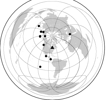
Nearby stations (2 deg radius)
| Station | Name | (Lat, Lon) | Start / End | Elevation |
| VBOI | XB.VBOI | (49.10, -79.14) | 1996-05-17 / 1996-12-31 | 0.0 m |
| Crust2 Type: | H1,early/mid Proter., no seds. |
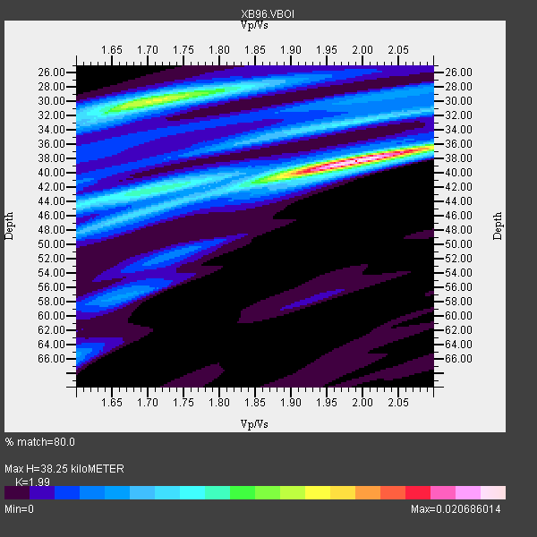
| Thickness Estimate: | 38 km |
| Thickness StdDev: | 1.6 km |
| Vp/Vs Estimate: | 1.99 |
| Vp/Vs StdDev: | 0.08 |
| Vs Estimate: | 3.322 km/s |
| Poisson's Ratio: | 0.33 |
| Peak Value: | 0.02 |
| Assumed Vp: | 6.61 km/s |
| Ps Weight: | 0.33333334 |
| PpPs Weight: | 0.33333334 |
| PsPs Weight: | 0.33333328 |
| Residual Complexity: | 0.686 |
| Nearby stations H: | +- |
| (2.0 deg) Vp/Vs: | +- |
6 with match > 90% ( 19.35484 %) and 15 with match > 80% ( 48.387096 %) out of 31.
Download stack as xyz text file.
Azimuth Distribution of Events:
Prior Results for this Station
| Study | Thickness | Vp/Vs | Vp | Vs | Poissons Ratio | Extra |
| EARS | 38 km | 1.99 | 6.61 km/s | 3.322 km/s | 0.33 | |
| Crust2.0 | 40 km | 1.77 | 6.61 km/s | 3.725 km/s | 0.27 | H1,early/mid Proter., no seds. |
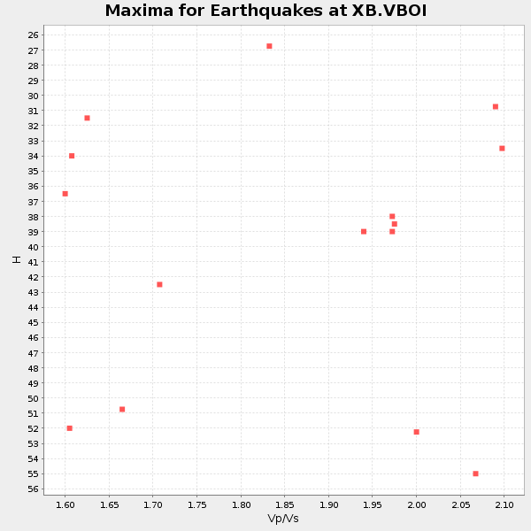
| Global Maxima | 38 km | 1.99 | 6.61 km/s | 3.322 km/s | 0.33 | amp=0.020686014 |
| Local Maxima 1 | 30 km | 1.71 | 6.61 km/s | 3.86 km/s | 0.24 | amp=0.012545904 |
| Local Maxima 2 | 33 km | 1.98 | 6.61 km/s | 3.343 km/s | 0.33 | amp=0.007311353 |
| Local Maxima 3 | 44 km | 1.74 | 6.61 km/s | 3.793 km/s | 0.25 | amp=0.005909931 |
| Local Maxima 4 | 44 km | 1.60 | 6.61 km/s | 4.125 km/s | 0.18 | amp=0.0054456093 |
| Predicted Arrivals for vertical incidence (zero ray parameter) | |
| Ps | 5.73 SECOND |
| PpPs | 17.30 SECOND |
| PsPs/PpSs | 23.03 SECOND |
Events Processed for this Station
Download zip of receiver functions as SAC
Plot maxima for each earthquake.
Events Used in the Stack
(15 events)| Radial Match | Distance | Baz | FERegion | Time | Lat/Lon | Depth | Magnitude |
| 98.48379 | 58.1 deg | 313.355 deg | Andreanof Islands, Aleutian Is. | 1996/06/10 04:03:35 GMT | (51.6, -177.6) | 33 km | 6.6 MB, 7.6 MS, 7.9 UNKNOWN, 7.4 MS |
| 98.3749 | 57.8 deg | 312.906 deg | Andreanof Islands, Aleutian Is. | 1996/06/10 15:24:56 GMT | (51.5, -176.8) | 26 km | 5.9 MB, 7.1 MS, 7.2 UNKNOWN, 6.9 MS |
| 97.638435 | 68.1 deg | 325.101 deg | Off East Coast Of Kamchatka | 1996/06/21 13:57:10 GMT | (51.6, 159.1) | 20 km | 6.0 MB, 6.6 MS, 7.0 UNKNOWN, 6.5 MS |
| 94.78329 | 58.4 deg | 313.524 deg | Andreanof Islands, Aleutian Is. | 1996/06/08 23:19:15 GMT | (51.5, -178.1) | 33 km | 5.9 MB, 6.3 MS, 6.5 UNKNOWN, 6.1 MS |
| 93.719124 | 36.1 deg | 217.036 deg | Guerrero, Mexico | 1996/07/15 21:23:34 GMT | (17.6, -101.0) | 18 km | 5.7 MB, 6.5 MS, 6.6 UNKNOWN, 6.2 ME |
| 90.7256 | 77.2 deg | 212.393 deg | Easter Island Region | 1996/09/05 08:14:14 GMT | (-22.1, -113.4) | 10 km | 6.2 MB, 7.0 MS, 7.0 UNKNOWN, 6.9 MW |
| 89.98079 | 39.8 deg | 187.904 deg | Costa Rica | 1996/09/04 19:06:49 GMT | (9.4, -84.3) | 33 km | 5.8 MB, 5.9 MS, 6.2 UNKNOWN, 6.1 MW |
| 88.84302 | 88.5 deg | 328.307 deg | Near East Coast Of Honshu, Japan | 1996/09/11 02:37:14 GMT | (35.5, 140.9) | 55 km | 6.1 MB, 5.7 MS, 6.2 UNKNOWN, 6.1 MW |
| 87.110565 | 63.0 deg | 330.522 deg | Kamchatka Peninsula, Russia | 1996/07/07 10:49:59 GMT | (58.6, 157.8) | 10 km | 5.6 MB, 5.6 MS, 5.8 UNKNOWN, 5.8 MW |
| 84.43944 | 31.5 deg | 288.746 deg | Vancouver Island, Canada Region | 1996/10/06 20:13:09 GMT | (49.0, -127.9) | 10 km | 5.8 MB, 6.3 MS, 6.2 UNKNOWN, 6.2 MW |
| 84.29965 | 39.8 deg | 187.978 deg | Costa Rica | 1996/08/28 17:16:17 GMT | (9.4, -84.3) | 33 km | 5.5 MB, 5.5 MS, 5.9 UNKNOWN |
| 83.83557 | 47.6 deg | 327.907 deg | Near N. Coast Of Eastern Siberia | 1996/10/24 19:31:53 GMT | (67.0, -173.2) | 20 km | 6.0 MB, 5.9 MS, 6.1 UNKNOWN, 5.8 ME |
| 82.195724 | 76.8 deg | 52.193 deg | Cyprus Region | 1996/10/09 13:10:52 GMT | (34.6, 32.1) | 33 km | 6.4 MB, 6.8 MS, 7.2 UNKNOWN, 6.8 MW |
| 82.17344 | 57.6 deg | 312.442 deg | Andreanof Islands, Aleutian Is. | 1996/06/11 10:40:08 GMT | (51.3, -176.3) | 33 km | 5.6 MB, 5.6 MS, 6.0 UNKNOWN, 5.5 MS |
| 80.18648 | 68.0 deg | 324.879 deg | Off East Coast Of Kamchatka | 1996/07/18 22:55:03 GMT | (51.5, 159.4) | 33 km | 5.5 MB, 5.2 MS |
Losers
(16 events)| Radial Match | Distance | Baz | FERegion | Time | Lat/Lon | Depth | Magnitude | Reason |
| 73.78838 | 67.7 deg | 324.833 deg | Off East Coast Of Kamchatka | 1996/06/30 11:32:35 GMT | (51.7, 159.8) | 33 km | 5.5 MB, 5.9 MS, 6.1 UNKNOWN, 6.0 MW | |
| 73.73962 | 54.6 deg | 310.941 deg | Fox Islands, Aleutian Islands | 1996/07/10 05:48:19 GMT | (52.2, -171.1) | 33 km | 5.9 ML, 5.4 MS, 5.3 MB | |
| 72.11306 | 68.2 deg | 324.926 deg | Off East Coast Of Kamchatka | 1996/06/22 14:50:07 GMT | (51.4, 159.2) | 33 km | 5.6 MB, 6.0 MS, 6.2 UNKNOWN, 6.2 MW | |
| 71.82274 | 80.9 deg | 173.473 deg | Near Coast Of Central Chile | 1996/09/09 00:20:39 GMT | (-31.9, -71.6) | 39 km | 6.0 MB, 5.5 MS, 6.0 UNKNOWN, 5.8 ME | |
| 69.4818 | 37.9 deg | 190.125 deg | Nicaragua | 1996/09/18 17:34:20 GMT | (11.4, -85.5) | 193 km | 5.7 UNKNOWN, 5.3 MB, 5.5 MW | |
| 68.51928 | 58.5 deg | 313.602 deg | Andreanof Islands, Aleutian Is. | 1996/08/19 04:19:16 GMT | (51.5, -178.4) | 33 km | 5.7 MB, 5.6 MS, 6.0 UNKNOWN, 5.7 ML | |
| 65.505684 | 63.2 deg | 54.9 deg | Adriatic Sea | 1996/09/05 20:44:09 GMT | (42.8, 17.9) | 10 km | 5.6 MB, 6.0 MS, 6.0 UNKNOWN, 5.7 MW | |
| 64.138115 | 72.6 deg | 171.586 deg | Near Coast Of Northern Chile | 1996/07/03 16:48:27 GMT | (-23.4, -70.4) | 33 km | 5.3 MB, 5.4 MS, 5.8 UNKNOWN | |
| 64.11738 | 73.5 deg | 46.128 deg | Turkey | 1996/08/14 01:55:02 GMT | (40.8, 35.3) | 10 km | 5.6 MS, 5.3 MB, 5.8 UNKNOWN, 5.7 MW | |
| 63.455547 | 77.0 deg | 212.106 deg | Easter Island Region | 1996/09/05 09:46:59 GMT | (-22.1, -113.1) | 10 km | 5.6 MB, 5.9 MS, 6.4 UNKNOWN | |
| 61.715992 | 58.5 deg | 313.501 deg | Andreanof Islands, Aleutian Is. | 1996/06/12 02:16:48 GMT | (51.4, -178.2) | 33 km | 5.5 MB, 5.3 MS, 5.7 UNKNOWN, 5.6 ML | |
| 54.392082 | 50.9 deg | 182.391 deg | Off Coast Of Ecuador | 1996/08/05 21:39:16 GMT | (-2.0, -81.0) | 33 km | 5.7 MB, 5.9 MS, 6.2 UNKNOWN, 6.2 MW | |
| 52.983627 | 70.2 deg | 329.707 deg | Sea Of Okhotsk | 1996/08/30 21:13:41 GMT | (52.3, 151.5) | 580 km | 5.5 UNKNOWN, 5.1 MB, 5.4 MW | |
| 50.130882 | 77.0 deg | 212.121 deg | Easter Island Region | 1996/09/05 09:10:20 GMT | (-22.1, -113.1) | 10 km | 5.6 MB, 6.3 MS | |
| 47.335567 | 89.0 deg | 9.088 deg | Southern Xinjiang, China | 1996/06/08 02:55:57 GMT | (41.7, 88.7) | 0.0 km | 5.9 MB, 4.3 MS | |
| 42.191463 | 76.4 deg | 325.913 deg | Kuril Islands | 1996/10/02 11:24:48 GMT | (45.1, 151.2) | 33 km | 6.1 MB, 5.4 MS, 6.0 UNKNOWN, 6.0 MW |
