
Station XB VSG4 - XB.VSG4
Network: XB96 - Abitibi Experiment
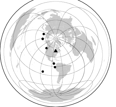
Nearby stations (2 deg radius)
| Station | Name | (Lat, Lon) | Start / End | Elevation |
| VSG4 | XB.VSG4 | (49.63, -79.00) | 1996-05-20 / 1996-12-31 | 0.0 m |
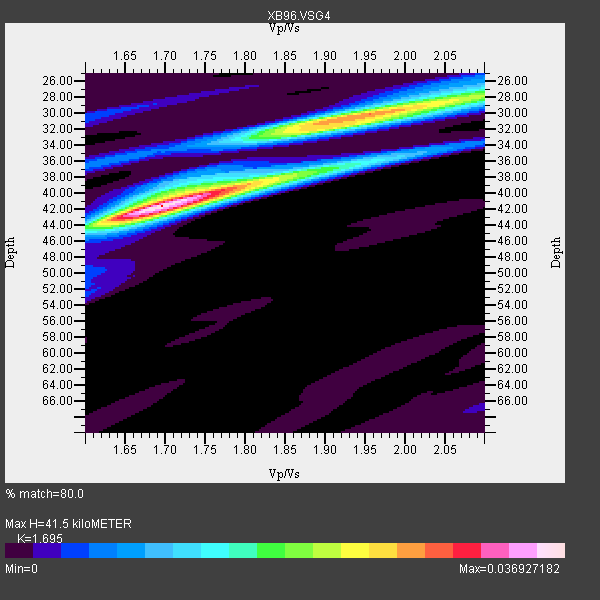
| Crust2 Type: | H1,early/mid Proter., no seds. |
| Thickness Estimate: | 42 km |
| Thickness StdDev: | 3.1 km |
| Vp/Vs Estimate: | 1.70 |
| Vp/Vs StdDev: | 0.07 |
| Vs Estimate: | 3.9 km/s |
| Poisson's Ratio: | 0.23 |
| Peak Value: | 0.04 |
| Assumed Vp: | 6.61 km/s |
| Ps Weight: | 0.33333334 |
| PpPs Weight: | 0.33333334 |
| PsPs Weight: | 0.33333328 |
| Residual Complexity: | 0.686 |
| Nearby stations H: | +- |
| (2.0 deg) Vp/Vs: | +- |
3 with match > 90% ( 13.636364 %) and 7 with match > 80% ( 31.818182 %) out of 22.
Download stack as xyz text file.
Azimuth Distribution of Events:
Prior Results for this Station
| Study | Thickness | Vp/Vs | Vp | Vs | Poissons Ratio | Extra |
| EARS | 42 km | 1.70 | 6.61 km/s | 3.9 km/s | 0.23 | |
| Crust2.0 | 40 km | 1.77 | 6.61 km/s | 3.725 km/s | 0.27 | H1,early/mid Proter., no seds. |
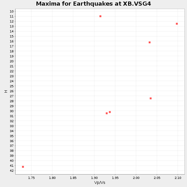
| Global Maxima | 42 km | 1.70 | 6.61 km/s | 3.9 km/s | 0.23 | amp=0.036927182 |
| Local Maxima 1 | 30 km | 1.96 | 6.61 km/s | 3.381 km/s | 0.32 | amp=0.02663234 |
| Local Maxima 2 | 38 km | 1.84 | 6.61 km/s | 3.602 km/s | 0.29 | amp=0.017265024 |
| Local Maxima 3 | 32 km | 1.87 | 6.61 km/s | 3.539 km/s | 0.30 | amp=0.014211487 |
| Local Maxima 4 | 27 km | 2.10 | 6.61 km/s | 3.151 km/s | 0.35 | amp=0.011705108 |
| Predicted Arrivals for vertical incidence (zero ray parameter) | |
| Ps | 4.36 SECOND |
| PpPs | 16.92 SECOND |
| PsPs/PpSs | 21.28 SECOND |
Events Processed for this Station
Download zip of receiver functions as SAC
Plot maxima for each earthquake.
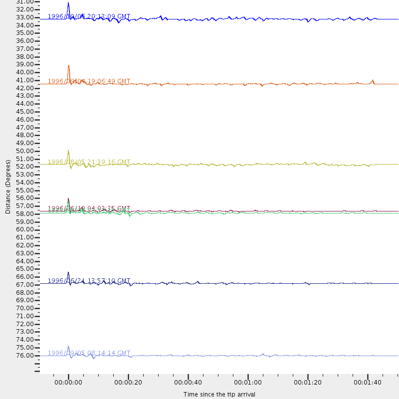
Events Used in the Stack
(7 events)| Radial Match | Distance | Baz | FERegion | Time | Lat/Lon | Depth | Magnitude |
| 98.04124 | 57.8 deg | 313.184 deg | Andreanof Islands, Aleutian Is. | 1996/06/10 04:03:35 GMT | (51.6, -177.6) | 33 km | 6.6 MB, 7.6 MS, 7.9 UNKNOWN, 7.4 MS |
| 97.03386 | 67.7 deg | 325.056 deg | Off East Coast Of Kamchatka | 1996/06/21 13:57:10 GMT | (51.6, 159.1) | 20 km | 6.0 MB, 6.6 MS, 7.0 UNKNOWN, 6.5 MS |
| 94.258995 | 58.1 deg | 313.357 deg | Andreanof Islands, Aleutian Is. | 1996/06/08 23:19:15 GMT | (51.5, -178.1) | 33 km | 5.9 MB, 6.3 MS, 6.5 UNKNOWN, 6.1 MS |
| 87.08597 | 40.4 deg | 188.037 deg | Costa Rica | 1996/09/04 19:06:49 GMT | (9.4, -84.3) | 33 km | 5.8 MB, 5.9 MS, 6.2 UNKNOWN, 6.1 MW |
| 86.816505 | 77.7 deg | 212.457 deg | Easter Island Region | 1996/09/05 08:14:14 GMT | (-22.1, -113.4) | 10 km | 6.2 MB, 7.0 MS, 7.0 UNKNOWN, 6.9 MW |
| 86.24433 | 51.4 deg | 182.557 deg | Off Coast Of Ecuador | 1996/08/05 21:39:16 GMT | (-2.0, -81.0) | 33 km | 5.7 MB, 5.9 MS, 6.2 UNKNOWN, 6.2 MW |
| 84.21247 | 31.4 deg | 287.993 deg | Vancouver Island, Canada Region | 1996/10/06 20:13:09 GMT | (49.0, -127.9) | 10 km | 5.8 MB, 6.3 MS, 6.2 UNKNOWN, 6.2 MW |
Losers
(15 events)| Radial Match | Distance | Baz | FERegion | Time | Lat/Lon | Depth | Magnitude | Reason |
| 77.13002 | 62.6 deg | 330.456 deg | Kamchatka Peninsula, Russia | 1996/07/07 10:49:59 GMT | (58.6, 157.8) | 10 km | 5.6 MB, 5.6 MS, 5.8 UNKNOWN, 5.8 MW | |
| 76.51729 | 76.4 deg | 52.387 deg | Cyprus Region | 1996/10/09 13:10:52 GMT | (34.6, 32.1) | 33 km | 6.4 MB, 6.8 MS, 7.2 UNKNOWN, 6.8 MW | |
| 75.42031 | 47.2 deg | 327.686 deg | Near N. Coast Of Eastern Siberia | 1996/10/24 19:31:53 GMT | (67.0, -173.2) | 20 km | 6.0 MB, 5.9 MS, 6.1 UNKNOWN, 5.8 ME | |
| 75.07341 | 40.4 deg | 188.11 deg | Costa Rica | 1996/08/28 17:16:17 GMT | (9.4, -84.3) | 33 km | 5.5 MB, 5.5 MS, 5.9 UNKNOWN | |
| 74.6524 | 57.3 deg | 312.264 deg | Andreanof Islands, Aleutian Is. | 1996/06/11 10:40:08 GMT | (51.3, -176.3) | 33 km | 5.6 MB, 5.6 MS, 6.0 UNKNOWN, 5.5 MS | |
| 71.72789 | 81.4 deg | 173.605 deg | Near Coast Of Central Chile | 1996/09/09 00:20:39 GMT | (-31.9, -71.6) | 39 km | 6.0 MB, 5.5 MS, 6.0 UNKNOWN, 5.8 ME | |
| 68.35534 | 95.6 deg | 326.117 deg | Bonin Islands, Japan Region | 1996/06/26 03:22:03 GMT | (27.7, 139.7) | 469 km | 5.5 MB, 6.3 UNKNOWN, 5.4 MB | |
| 68.29367 | 54.3 deg | 310.722 deg | Fox Islands, Aleutian Islands | 1996/07/10 05:48:19 GMT | (52.2, -171.1) | 33 km | 5.9 ML, 5.4 MS, 5.3 MB | |
| 62.646385 | 76.0 deg | 325.931 deg | Kuril Islands | 1996/10/02 11:24:48 GMT | (45.1, 151.2) | 33 km | 6.1 MB, 5.4 MS, 6.0 UNKNOWN, 6.0 MW | |
| 62.046555 | 37.2 deg | 151.209 deg | Leeward Islands | 1996/09/24 11:42:18 GMT | (15.2, -61.4) | 147 km | 6.0 MB, 5.9 UNKNOWN, 5.7 MW | |
| 57.95398 | 69.8 deg | 329.69 deg | Sea Of Okhotsk | 1996/08/30 21:13:41 GMT | (52.3, 151.5) | 580 km | 5.5 UNKNOWN, 5.1 MB, 5.4 MW | |
| 57.269848 | 38.5 deg | 190.234 deg | Nicaragua | 1996/09/18 17:34:20 GMT | (11.4, -85.5) | 193 km | 5.7 UNKNOWN, 5.3 MB, 5.5 MW | |
| 53.478287 | 69.0 deg | 329.435 deg | Northwest Of Kuril Islands | 1996/10/08 07:52:58 GMT | (52.9, 152.5) | 627 km | 5.6 UNKNOWN, 5.2 MB | |
| 52.299454 | 88.5 deg | 9.196 deg | Southern Xinjiang, China | 1996/06/08 02:55:57 GMT | (41.7, 88.7) | 0.0 km | 5.9 MB, 4.3 MS | |
| 48.072056 | 58.2 deg | 313.437 deg | Andreanof Islands, Aleutian Is. | 1996/08/19 04:19:16 GMT | (51.5, -178.4) | 33 km | 5.7 MB, 5.6 MS, 6.0 UNKNOWN, 5.7 ML |
