
Station XB VSGL - XB.VSGL
Network: XB96 - Abitibi Experiment
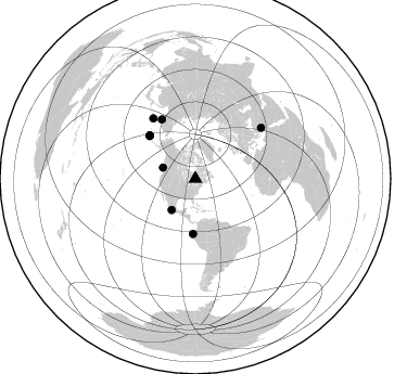
Nearby stations (2 deg radius)
| Station | Name | (Lat, Lon) | Start / End | Elevation |
| VSGL | XB.VSGL | (49.01, -79.11) | 1996-05-19 / 1996-12-31 | 0.0 m |
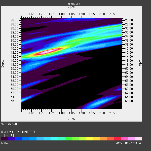
| Crust2 Type: | H1,early/mid Proter., no seds. |
| Thickness Estimate: | 41 km |
| Thickness StdDev: | 3.5 km |
| Vp/Vs Estimate: | 1.73 |
| Vp/Vs StdDev: | 0.10 |
| Vs Estimate: | 3.821 km/s |
| Poisson's Ratio: | 0.25 |
| Peak Value: | 0.02 |
| Assumed Vp: | 6.61 km/s |
| Ps Weight: | 0.33333334 |
| PpPs Weight: | 0.33333334 |
| PsPs Weight: | 0.33333328 |
| Residual Complexity: | 0.666 |
| Nearby stations H: | +- |
| (2.0 deg) Vp/Vs: | +- |
6 with match > 90% ( 35.294117 %) and 9 with match > 80% ( 52.941177 %) out of 17.
Download stack as xyz text file.
Azimuth Distribution of Events:
Prior Results for this Station
| Study | Thickness | Vp/Vs | Vp | Vs | Poissons Ratio | Extra |
| EARS | 41 km | 1.73 | 6.61 km/s | 3.821 km/s | 0.25 | |
| Crust2.0 | 40 km | 1.77 | 6.61 km/s | 3.725 km/s | 0.27 | H1,early/mid Proter., no seds. |
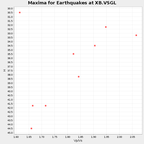
| Global Maxima | 41 km | 1.73 | 6.61 km/s | 3.821 km/s | 0.25 | amp=0.019776454 |
| Local Maxima 1 | 35 km | 1.91 | 6.61 km/s | 3.465 km/s | 0.31 | amp=0.010136066 |
| Local Maxima 2 | 29 km | 2.04 | 6.61 km/s | 3.248 km/s | 0.34 | amp=0.0083701555 |
| Local Maxima 3 | 66 km | 1.60 | 6.61 km/s | 4.131 km/s | 0.18 | amp=0.00803245 |
| Local Maxima 4 | 33 km | 2.10 | 6.61 km/s | 3.151 km/s | 0.35 | amp=0.0073031387 |
| Predicted Arrivals for vertical incidence (zero ray parameter) | |
| Ps | 4.56 SECOND |
| PpPs | 17.04 SECOND |
| PsPs/PpSs | 21.59 SECOND |
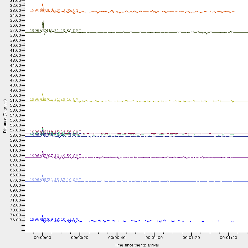
Events Processed for this Station
Download zip of receiver functions as SAC
Plot maxima for each earthquake.
Events Used in the Stack
(9 events)| Radial Match | Distance | Baz | FERegion | Time | Lat/Lon | Depth | Magnitude |
| 98.32903 | 57.9 deg | 312.965 deg | Andreanof Islands, Aleutian Is. | 1996/06/10 15:24:56 GMT | (51.5, -176.8) | 26 km | 5.9 MB, 7.1 MS, 7.2 UNKNOWN, 6.9 MS |
| 98.128876 | 58.2 deg | 313.413 deg | Andreanof Islands, Aleutian Is. | 1996/06/10 04:03:35 GMT | (51.6, -177.6) | 33 km | 6.6 MB, 7.6 MS, 7.9 UNKNOWN, 7.4 MS |
| 97.48834 | 68.2 deg | 325.141 deg | Off East Coast Of Kamchatka | 1996/06/21 13:57:10 GMT | (51.6, 159.1) | 20 km | 6.0 MB, 6.6 MS, 7.0 UNKNOWN, 6.5 MS |
| 95.82794 | 58.5 deg | 313.582 deg | Andreanof Islands, Aleutian Is. | 1996/06/08 23:19:15 GMT | (51.5, -178.1) | 33 km | 5.9 MB, 6.3 MS, 6.5 UNKNOWN, 6.1 MS |
| 93.49617 | 36.0 deg | 217.164 deg | Guerrero, Mexico | 1996/07/15 21:23:34 GMT | (17.6, -101.0) | 18 km | 5.7 MB, 6.5 MS, 6.6 UNKNOWN, 6.2 ME |
| 92.229546 | 50.8 deg | 182.439 deg | Off Coast Of Ecuador | 1996/08/05 21:39:16 GMT | (-2.0, -81.0) | 33 km | 5.7 MB, 5.9 MS, 6.2 UNKNOWN, 6.2 MW |
| 88.04904 | 63.1 deg | 330.562 deg | Kamchatka Peninsula, Russia | 1996/07/07 10:49:59 GMT | (58.6, 157.8) | 10 km | 5.6 MB, 5.6 MS, 5.8 UNKNOWN, 5.8 MW |
| 86.3066 | 31.5 deg | 288.903 deg | Vancouver Island, Canada Region | 1996/10/06 20:13:09 GMT | (49.0, -127.9) | 10 km | 5.8 MB, 6.3 MS, 6.2 UNKNOWN, 6.2 MW |
| 84.33239 | 76.8 deg | 52.199 deg | Cyprus Region | 1996/10/09 13:10:52 GMT | (34.6, 32.1) | 33 km | 6.4 MB, 6.8 MS, 7.2 UNKNOWN, 6.8 MW |
Losers
(8 events)| Radial Match | Distance | Baz | FERegion | Time | Lat/Lon | Depth | Magnitude | Reason |
| 79.81725 | 72.5 deg | 171.615 deg | Near Coast Of Northern Chile | 1996/07/03 16:48:27 GMT | (-23.4, -70.4) | 33 km | 5.3 MB, 5.4 MS, 5.8 UNKNOWN | |
| 77.412476 | 67.8 deg | 324.873 deg | Off East Coast Of Kamchatka | 1996/06/30 11:32:35 GMT | (51.7, 159.8) | 33 km | 5.5 MB, 5.9 MS, 6.1 UNKNOWN, 6.0 MW | |
| 73.704285 | 57.7 deg | 312.502 deg | Andreanof Islands, Aleutian Is. | 1996/06/11 10:40:08 GMT | (51.3, -176.3) | 33 km | 5.6 MB, 5.6 MS, 6.0 UNKNOWN, 5.5 MS | |
| 65.07912 | 54.7 deg | 311.006 deg | Fox Islands, Aleutian Islands | 1996/07/10 05:48:19 GMT | (52.2, -171.1) | 33 km | 5.9 ML, 5.4 MS, 5.3 MB | |
| 64.766205 | 85.7 deg | 330.057 deg | Eastern Honshu, Japan | 1996/08/10 18:12:17 GMT | (38.9, 140.5) | 10 km | 6.0 MB, 5.7 MS, 5.9 UNKNOWN, 5.9 MW | |
| 59.00406 | 68.1 deg | 324.919 deg | Off East Coast Of Kamchatka | 1996/07/18 22:55:03 GMT | (51.5, 159.4) | 33 km | 5.5 MB, 5.2 MS | |
| 56.18946 | 76.5 deg | 325.947 deg | Kuril Islands | 1996/10/02 11:24:48 GMT | (45.1, 151.2) | 33 km | 6.1 MB, 5.4 MS, 6.0 UNKNOWN, 6.0 MW | |
| 54.13074 | 32.4 deg | 290.82 deg | Vancouver Island, Canada Region | 1996/10/09 07:12:25 GMT | (49.7, -129.6) | 10 km | 5.7 MS, 5.3 MB, 5.8 UNKNOWN |
