
Station XB ELEF - Elephant Island, South Shetland Is.
Network: XB97 - Seismic Experiment in Patagonia and Antarctica
Nearby stations (2 deg radius)
| Station | Name | (Lat, Lon) | Start / End | Elevation |
| ELEF | Elephant Island, South Shetland Is. | (-61.22, -55.14) | 1997-01-20 / 2000-12-31 | 30 m |
| Crust2 Type: | B1,melt affected o.c. and oceanic plateaus, 0.5 km seds. |
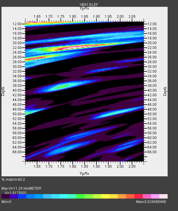
| Thickness Estimate: | 11 km |
| Thickness StdDev: | 7.7 km |
| Vp/Vs Estimate: | 1.62 |
| Vp/Vs StdDev: | 0.11 |
| Vs Estimate: | 2.924 km/s |
| Poisson's Ratio: | 0.19 |
| Peak Value: | 0.03 |
| Assumed Vp: | 4.73 km/s |
| Ps Weight: | 0.33333334 |
| PpPs Weight: | 0.33333334 |
| PsPs Weight: | 0.33333328 |
| Residual Complexity: | 0.916 |
| Nearby stations H: | +- |
| (2.0 deg) Vp/Vs: | +- |
2 with match > 90% ( 15.384615 %) and 6 with match > 80% ( 46.153847 %) out of 13.
Download stack as xyz text file.
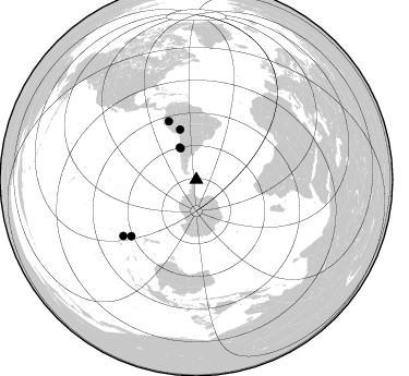
Azimuth Distribution of Events:
Prior Results for this Station
| Study | Thickness | Vp/Vs | Vp | Vs | Poissons Ratio | Extra |
| EARS | 11 km | 1.62 | 4.73 km/s | 2.924 km/s | 0.19 | |
| Crust2.0 | 16 km | 2.06 | 4.73 km/s | 2.3 km/s | 0.35 | B1,melt affected o.c. and oceanic plateaus, 0.5 km seds. |
| Global Maxima | 11 km | 1.62 | 4.73 km/s | 2.924 km/s | 0.19 | amp=0.034898486 |
| Local Maxima 1 | 22 km | 1.83 | 4.73 km/s | 2.592 km/s | 0.29 | amp=0.03471347 |
| Local Maxima 2 | 26 km | 1.63 | 4.73 km/s | 2.893 km/s | 0.20 | amp=0.028611036 |
| Local Maxima 3 | 50 km | 1.60 | 4.73 km/s | 2.952 km/s | 0.18 | amp=0.018347815 |
| Local Maxima 4 | 50 km | 1.97 | 4.73 km/s | 2.407 km/s | 0.33 | amp=0.015866408 |
| Predicted Arrivals for vertical incidence (zero ray parameter) | |
| Ps | 1.47 SECOND |
| PpPs | 6.23 SECOND |
| PsPs/PpSs | 7.69 SECOND |
Events Processed for this Station
Download zip of receiver functions as SAC
Plot maxima for each earthquake.
Events Used in the Stack
(6 events)| Radial Match | Distance | Baz | FERegion | Time | Lat/Lon | Depth | Magnitude |
| 93.61696 | 33.1 deg | 332.786 deg | Near Coast Of Central Chile | 1997/07/06 09:54:00 GMT | (-30.1, -71.9) | 19 km | 5.8 MB, 6.5 MS, 6.8 UNKNOWN, 6.4 ME |
| 90.263466 | 59.0 deg | 334.714 deg | Northern Peru | 1997/10/28 06:15:17 GMT | (-4.4, -76.7) | 112 km | 6.6 MB, 6.3 MS, 7.2 UNKNOWN, 6.6 ME |
| 88.45392 | 84.7 deg | 232.464 deg | South Of Fiji Islands | 1997/10/14 09:53:18 GMT | (-22.1, -176.8) | 167 km | 6.7 MB, 7.7 UNKNOWN, 7.4 ME |
| 84.17741 | 79.1 deg | 229.011 deg | Kermadec Islands Region | 1997/09/20 16:11:32 GMT | (-28.7, -177.6) | 30 km | 6.1 MB, 7.0 MS, 7.2 UNKNOWN, 6.7 ME |
| 81.6322 | 32.1 deg | 333.385 deg | Near Coast Of Central Chile | 1997/10/15 01:03:33 GMT | (-30.9, -71.2) | 58 km | 6.8 MB, 6.8 MS, 7.3 UNKNOWN, 7.1 MW |
| 80.923485 | 48.4 deg | 342.152 deg | Peru-Bolivia Border Region | 1997/11/28 22:53:41 GMT | (-13.7, -68.8) | 586 km | 6.4 MB, 6.6 UNKNOWN, 6.6 MW |
Losers
(7 events)| Radial Match | Distance | Baz | FERegion | Time | Lat/Lon | Depth | Magnitude | Reason |
| 78.426575 | 84.5 deg | 234.802 deg | Tonga Islands | 1997/09/10 12:57:07 GMT | (-21.3, -174.4) | 10 km | 5.7 MB, 6.1 MS, 6.1 UNKNOWN, 5.9 MW | |
| 75.13097 | 96.7 deg | 221.081 deg | Vanuatu Islands | 1997/11/15 18:59:24 GMT | (-15.1, 167.4) | 123 km | 6.4 MB, 7.0 UNKNOWN, 6.8 ME | |
| 66.03629 | 66.9 deg | 337.514 deg | Colombia | 1997/12/11 07:56:28 GMT | (3.9, -75.8) | 178 km | 6.0 MB, 6.4 UNKNOWN, 6.3 MW | |
| 65.790565 | 82.5 deg | 226.551 deg | South Of Fiji Islands | 1997/09/04 04:23:37 GMT | (-26.6, 178.3) | 625 km | 6.3 MB, 6.8 UNKNOWN, 6.5 ME | |
| 64.465744 | 78.7 deg | 228.828 deg | Kermadec Islands, New Zealand | 1997/11/18 15:41:29 GMT | (-29.1, -177.7) | 52 km | 5.7 MB, 5.5 MS | |
| 60.785065 | 39.9 deg | 340.591 deg | Northern Chile | 1997/09/28 23:13:13 GMT | (-22.4, -68.4) | 107 km | 5.7 MB, 5.6 UNKNOWN, 5.6 MW | |
| 57.441128 | 86.6 deg | 231.197 deg | Fiji Islands Region | 1997/10/17 15:02:00 GMT | (-20.9, -178.8) | 579 km | 5.3 MB, 6.0 UNKNOWN, 6.0 MW |
