
Station XB FREI - Base Frei, South Shetland Is.
Network: XB97 - Seismic Experiment in Patagonia and Antarctica
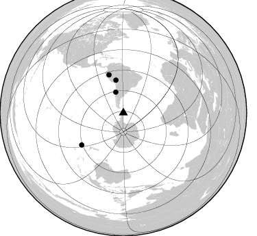
Nearby stations (2 deg radius)
| Station | Name | (Lat, Lon) | Start / End | Elevation |
| FREI | Base Frei, South Shetland Is. | (-62.19, -58.98) | 1997-01-23 / 2000-12-31 | 37 m |
| Crust2 Type: | S1,continental slope, margin, transition 1 km seds. |
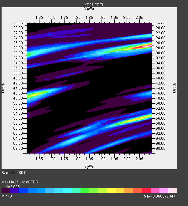
| Thickness Estimate: | 27 km |
| Thickness StdDev: | 14 km |
| Vp/Vs Estimate: | 2.10 |
| Vp/Vs StdDev: | 0.13 |
| Vs Estimate: | 2.951 km/s |
| Poisson's Ratio: | 0.35 |
| Peak Value: | 0.06 |
| Assumed Vp: | 6.183 km/s |
| Ps Weight: | 0.33333334 |
| PpPs Weight: | 0.33333334 |
| PsPs Weight: | 0.33333328 |
| Residual Complexity: | 0.742 |
| Nearby stations H: | +- |
| (2.0 deg) Vp/Vs: | +- |
2 with match > 90% ( 11.764706 %) and 4 with match > 80% ( 23.529411 %) out of 17.
Download stack as xyz text file.
Azimuth Distribution of Events:
Prior Results for this Station
| Study | Thickness | Vp/Vs | Vp | Vs | Poissons Ratio | Extra |
| EARS | 27 km | 2.10 | 6.183 km/s | 2.951 km/s | 0.35 | |
| Crust2.0 | 23 km | 1.81 | 6.183 km/s | 3.422 km/s | 0.28 | S1,continental slope, margin, transition 1 km seds. |
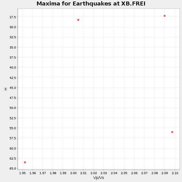
| Global Maxima | 27 km | 2.10 | 6.183 km/s | 2.951 km/s | 0.35 | amp=0.060077347 |
| Local Maxima 1 | 56 km | 2.05 | 6.183 km/s | 3.02 km/s | 0.34 | amp=0.0407037 |
| Local Maxima 2 | 30 km | 1.60 | 6.183 km/s | 3.864 km/s | 0.18 | amp=0.029327517 |
| Local Maxima 3 | 46 km | 1.65 | 6.183 km/s | 3.741 km/s | 0.21 | amp=0.028362148 |
| Local Maxima 4 | 23 km | 2.09 | 6.183 km/s | 2.958 km/s | 0.35 | amp=0.024976818 |
| Predicted Arrivals for vertical incidence (zero ray parameter) | |
| Ps | 4.78 SECOND |
| PpPs | 13.52 SECOND |
| PsPs/PpSs | 18.30 SECOND |
Events Processed for this Station
Download zip of receiver functions as SAC
Plot maxima for each earthquake.
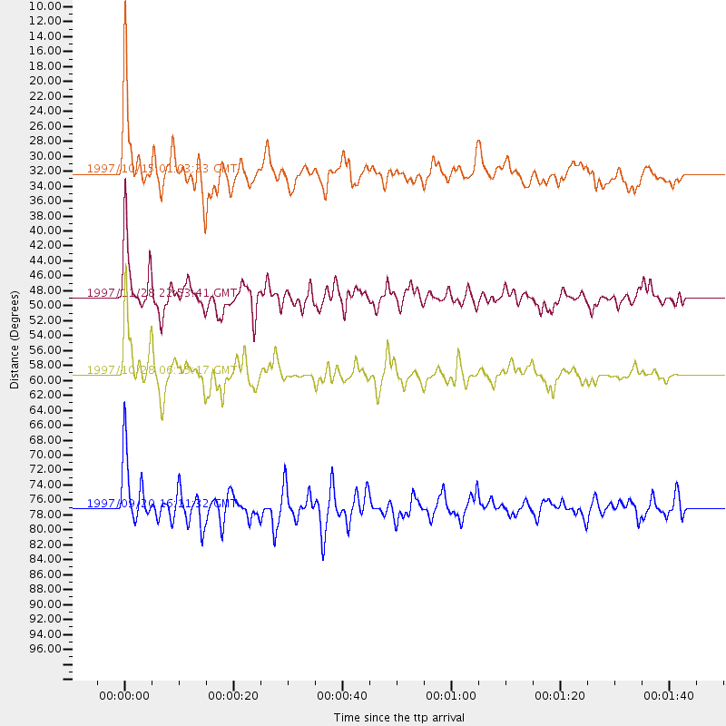
Events Used in the Stack
(4 events)| Radial Match | Distance | Baz | FERegion | Time | Lat/Lon | Depth | Magnitude |
| 90.60695 | 59.2 deg | 339.333 deg | Northern Peru | 1997/10/28 06:15:17 GMT | (-4.4, -76.7) | 112 km | 6.6 MB, 6.3 MS, 7.2 UNKNOWN, 6.6 ME |
| 90.45952 | 32.3 deg | 340.055 deg | Near Coast Of Central Chile | 1997/10/15 01:03:33 GMT | (-30.9, -71.2) | 58 km | 6.8 MB, 6.8 MS, 7.3 UNKNOWN, 7.1 MW |
| 85.697205 | 77.0 deg | 232.306 deg | Kermadec Islands Region | 1997/09/20 16:11:32 GMT | (-28.7, -177.6) | 30 km | 6.1 MB, 7.0 MS, 7.2 UNKNOWN, 6.7 ME |
| 80.71574 | 48.9 deg | 347.314 deg | Peru-Bolivia Border Region | 1997/11/28 22:53:41 GMT | (-13.7, -68.8) | 586 km | 6.4 MB, 6.6 UNKNOWN, 6.6 MW |
Losers
(13 events)| Radial Match | Distance | Baz | FERegion | Time | Lat/Lon | Depth | Magnitude | Reason |
| 79.35964 | 82.7 deg | 235.814 deg | South Of Fiji Islands | 1997/10/14 09:53:18 GMT | (-22.1, -176.8) | 167 km | 6.7 MB, 7.7 UNKNOWN, 7.4 ME | |
| 75.39054 | 79.3 deg | 330.557 deg | El Salvador | 1997/11/09 22:56:42 GMT | (13.8, -88.8) | 176 km | 5.6 MB, 6.4 UNKNOWN, 5.0 MD | |
| 75.25818 | 89.5 deg | 314.989 deg | Off Coast Of Jalisco, Mexico | 1997/05/01 11:37:36 GMT | (19.0, -107.3) | 33 km | 6.1 MB, 6.8 MS, 7.1 UNKNOWN, 7.1 ME | |
| 71.91511 | 80.4 deg | 229.858 deg | South Of Fiji Islands | 1997/09/04 04:23:37 GMT | (-26.6, 178.3) | 625 km | 6.3 MB, 6.8 UNKNOWN, 6.5 ME | |
| 70.32485 | 67.1 deg | 341.795 deg | Colombia | 1997/09/02 12:13:22 GMT | (3.8, -75.7) | 199 km | 6.5 MB, 6.8 UNKNOWN, 6.4 ME | |
| 66.03624 | 45.7 deg | 209.526 deg | Balleny Islands Region | 1997/09/23 17:51:23 GMT | (-65.5, 178.8) | 10 km | 5.9 MS, 5.0 MB | |
| 65.87136 | 94.8 deg | 224.531 deg | Vanuatu Islands | 1997/11/15 18:59:24 GMT | (-15.1, 167.4) | 123 km | 6.4 MB, 7.0 UNKNOWN, 6.8 ME | |
| 57.014908 | 84.6 deg | 234.552 deg | Fiji Islands Region | 1997/10/17 15:02:00 GMT | (-20.9, -178.8) | 579 km | 5.3 MB, 6.0 UNKNOWN, 6.0 MW | |
| 54.06791 | 33.4 deg | 340.546 deg | Near Coast Of Central Chile | 1997/03/09 11:43:43 GMT | (-29.8, -71.1) | 33 km | 5.5 MB, 5.7 MS, 6.2 UNKNOWN, 6.2 MW | |
| 53.050312 | 67.2 deg | 341.767 deg | Colombia | 1997/12/11 07:56:28 GMT | (3.9, -75.8) | 178 km | 6.0 MB, 6.4 UNKNOWN, 6.3 MW | |
| 42.36904 | 44.5 deg | 345.634 deg | Northern Chile | 1997/04/01 18:33:32 GMT | (-18.3, -69.5) | 114 km | 5.9 MB, 6.2 UNKNOWN, 6.1 MW | |
| 33.82239 | 40.3 deg | 346.389 deg | Northern Chile | 1997/09/28 23:13:13 GMT | (-22.4, -68.4) | 107 km | 5.7 MB, 5.6 UNKNOWN, 5.6 MW | |
| 28.920473 | 96.7 deg | 224.173 deg | Vanuatu Islands | 1997/04/21 12:15:56 GMT | (-13.4, 166.3) | 33 km | 6.0 MB |
