
Station XB OHIG - Base OHiggins, Antarctica
Network: XB97 - Seismic Experiment in Patagonia and Antarctica
Nearby stations (2 deg radius)
| Station | Name | (Lat, Lon) | Start / End | Elevation |
| OHIG | Base OHiggins, Antarctica | (-63.32, -57.90) | 1997-01-28 / 2000-12-31 | 10 m |
| Crust2 Type: | S1,continental slope, margin, transition 1 km seds. |
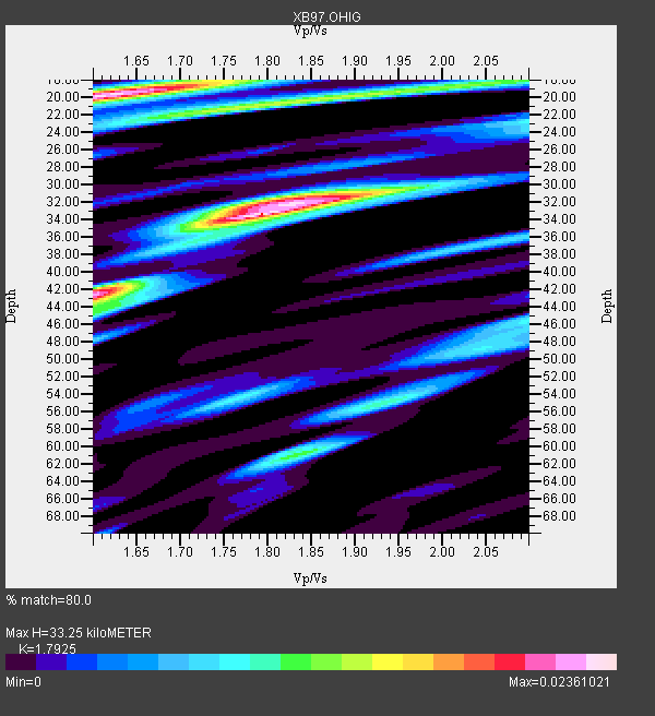
| Thickness Estimate: | 33 km |
| Thickness StdDev: | 7.3 km |
| Vp/Vs Estimate: | 1.79 |
| Vp/Vs StdDev: | 0.10 |
| Vs Estimate: | 3.449 km/s |
| Poisson's Ratio: | 0.27 |
| Peak Value: | 0.02 |
| Assumed Vp: | 6.183 km/s |
| Ps Weight: | 0.33333334 |
| PpPs Weight: | 0.33333334 |
| PsPs Weight: | 0.33333328 |
| Residual Complexity: | 0.781 |
| Nearby stations H: | +- |
| (2.0 deg) Vp/Vs: | +- |
1 with match > 90% ( 6.6666665 %) and 3 with match > 80% ( 20.0 %) out of 15.
Download stack as xyz text file.
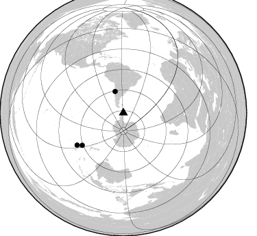
Azimuth Distribution of Events:
Prior Results for this Station
| Study | Thickness | Vp/Vs | Vp | Vs | Poissons Ratio | Extra |
| EARS | 33 km | 1.79 | 6.183 km/s | 3.449 km/s | 0.27 | |
| Crust2.0 | 23 km | 1.81 | 6.183 km/s | 3.422 km/s | 0.28 | S1,continental slope, margin, transition 1 km seds. |
| Global Maxima | 33 km | 1.79 | 6.183 km/s | 3.449 km/s | 0.27 | amp=0.02361021 |
| Local Maxima 1 | 20 km | 1.63 | 6.183 km/s | 3.799 km/s | 0.20 | amp=0.02271278 |
| Local Maxima 2 | 42 km | 1.60 | 6.183 km/s | 3.864 km/s | 0.18 | amp=0.018685631 |
| Local Maxima 3 | 21 km | 1.80 | 6.183 km/s | 3.435 km/s | 0.28 | amp=0.01382312 |
| Local Maxima 4 | 32 km | 1.83 | 6.183 km/s | 3.383 km/s | 0.29 | amp=0.013319127 |
| Predicted Arrivals for vertical incidence (zero ray parameter) | |
| Ps | 4.26 SECOND |
| PpPs | 15.02 SECOND |
| PsPs/PpSs | 19.28 SECOND |
Events Processed for this Station
Download zip of receiver functions as SAC
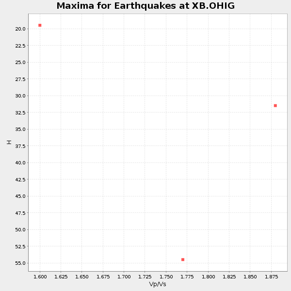
Plot maxima for each earthquake.
Events Used in the Stack
(3 events)| Radial Match | Distance | Baz | FERegion | Time | Lat/Lon | Depth | Magnitude |
| 92.47606 | 76.7 deg | 231.621 deg | Kermadec Islands Region | 1997/09/20 16:11:32 GMT | (-28.7, -177.6) | 30 km | 6.1 MB, 7.0 MS, 7.2 UNKNOWN, 6.7 ME |
| 87.76573 | 82.4 deg | 235.009 deg | South Of Fiji Islands | 1997/10/14 09:53:18 GMT | (-22.1, -176.8) | 167 km | 6.7 MB, 7.7 UNKNOWN, 7.4 ME |
| 86.72763 | 33.5 deg | 338.979 deg | Near Coast Of Central Chile | 1997/10/15 01:03:33 GMT | (-30.9, -71.2) | 58 km | 6.8 MB, 6.8 MS, 7.3 UNKNOWN, 7.1 MW |
Losers
(12 events)| Radial Match | Distance | Baz | FERegion | Time | Lat/Lon | Depth | Magnitude | Reason |
| 79.687904 | 68.3 deg | 340.785 deg | Colombia | 1997/09/02 12:13:22 GMT | (3.8, -75.7) | 199 km | 6.5 MB, 6.8 UNKNOWN, 6.4 ME | |
| 71.523026 | 83.3 deg | 232.409 deg | South Of Fiji Islands | 1997/12/26 05:34:24 GMT | (-22.3, -179.7) | 588 km | 5.9 UNKNOWN, 5.3 MB, 5.8 MW | |
| 70.33737 | 76.4 deg | 231.441 deg | Kermadec Islands, New Zealand | 1997/11/18 15:41:29 GMT | (-29.1, -177.7) | 52 km | 5.7 MB, 5.5 MS | |
| 53.237694 | 44.9 deg | 209.544 deg | Balleny Islands Region | 1997/09/23 17:51:23 GMT | (-65.5, 178.8) | 10 km | 5.9 MS, 5.0 MB | |
| 51.839195 | 81.7 deg | 326.385 deg | Near Coast Of Chiapas, Mexico | 1997/12/25 22:16:19 GMT | (14.1, -92.3) | 10 km | 5.4 MB, 5.3 MS, 5.8 UNKNOWN, 5.5 MD | |
| 48.40928 | 84.3 deg | 233.335 deg | Fiji Islands Region | 1997/11/04 10:40:43 GMT | (-21.0, -179.2) | 621 km | 5.7 UNKNOWN, 5.1 MB | |
| 48.09484 | 41.5 deg | 345.186 deg | Northern Chile | 1997/09/28 23:13:13 GMT | (-22.4, -68.4) | 107 km | 5.7 MB, 5.6 UNKNOWN, 5.6 MW | |
| 47.894657 | 80.6 deg | 329.616 deg | El Salvador | 1997/11/09 22:56:42 GMT | (13.8, -88.8) | 176 km | 5.6 MB, 6.4 UNKNOWN, 5.0 MD | |
| 46.894962 | 68.4 deg | 340.758 deg | Colombia | 1997/12/11 07:56:28 GMT | (3.9, -75.8) | 178 km | 6.0 MB, 6.4 UNKNOWN, 6.3 MW | |
| 45.027676 | 35.4 deg | 249.393 deg | Pacific-Antarctic Ridge | 1997/09/03 06:22:44 GMT | (-55.2, -129.0) | 10 km | 5.1 MB, 6.0 MS, 6.1 UNKNOWN, 6.0 MW | |
| 33.879177 | 82.1 deg | 236.64 deg | Tonga Islands | 1997/10/19 15:53:38 GMT | (-21.8, -175.0) | 33 km | 5.6 MB, 5.9 MS | |
| 30.9794 | 43.6 deg | 345.69 deg | Chile-Bolivia Border Region | 1997/12/09 14:23:45 GMT | (-20.2, -68.4) | 133 km | 5.7 MB, 5.7 UNKNOWN, 5.7 MW |
