
Station XB SALM - Salmon Farm, Seno Skyring, Patagonia
Network: XB97 - Seismic Experiment in Patagonia and Antarctica
Nearby stations (2 deg radius)
| Station | Name | (Lat, Lon) | Start / End | Elevation |
| SALM | Salmon Farm, Seno Skyring, Patagonia | (-52.55, -72.03) | 1997-01-06 / 2000-12-31 | 15 m |
| Crust2 Type: | L8,thin continental arc, Cordilleras, 0.5 km seds. |
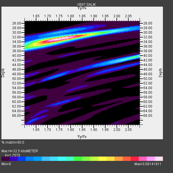
| Thickness Estimate: | 32 km |
| Thickness StdDev: | 0.6 km |
| Vp/Vs Estimate: | 1.76 |
| Vp/Vs StdDev: | 0.02 |
| Vs Estimate: | 3.736 km/s |
| Poisson's Ratio: | 0.26 |
| Peak Value: | 0.08 |
| Assumed Vp: | 6.566 km/s |
| Ps Weight: | 0.33333334 |
| PpPs Weight: | 0.33333334 |
| PsPs Weight: | 0.33333328 |
| Residual Complexity: | 0.408 |
| Nearby stations H: | +- |
| (2.0 deg) Vp/Vs: | +- |
0 with match > 90% ( 0.0 %) and 2 with match > 80% ( 28.571428 %) out of 7.
Download stack as xyz text file.
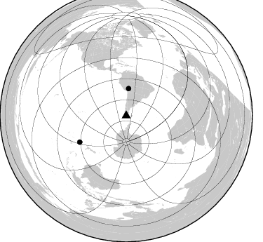
Azimuth Distribution of Events:
Prior Results for this Station
| Study | Thickness | Vp/Vs | Vp | Vs | Poissons Ratio | Extra |
| EARS | 32 km | 1.76 | 6.566 km/s | 3.736 km/s | 0.26 | |
| Crust2.0 | 34 km | 1.77 | 6.566 km/s | 3.707 km/s | 0.27 | L8,thin continental arc, Cordilleras, 0.5 km seds. |
| Global Maxima | 32 km | 1.76 | 6.566 km/s | 3.736 km/s | 0.26 | amp=0.08141911 |
| Local Maxima 1 | 41 km | 2.06 | 6.566 km/s | 3.184 km/s | 0.35 | amp=0.038499884 |
| Local Maxima 2 | 36 km | 1.65 | 6.566 km/s | 3.98 km/s | 0.21 | amp=0.033706848 |
| Local Maxima 3 | 30 km | 1.96 | 6.566 km/s | 3.35 km/s | 0.32 | amp=0.018819746 |
| Local Maxima 4 | 30 km | 1.72 | 6.566 km/s | 3.823 km/s | 0.24 | amp=0.013454128 |
| Predicted Arrivals for vertical incidence (zero ray parameter) | |
| Ps | 3.75 SECOND |
| PpPs | 13.65 SECOND |
| PsPs/PpSs | 17.40 SECOND |
Events Processed for this Station
Download zip of receiver functions as SAC
Plot maxima for each earthquake.
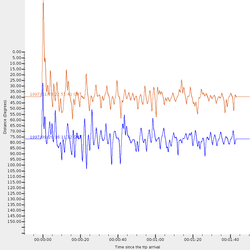
Events Used in the Stack
(2 events)| Radial Match | Distance | Baz | FERegion | Time | Lat/Lon | Depth | Magnitude |
| 89.89066 | 76.5 deg | 240.51 deg | Kermadec Islands Region | 1997/09/20 16:11:32 GMT | (-28.7, -177.6) | 30 km | 6.1 MB, 7.0 MS, 7.2 UNKNOWN, 6.7 ME |
| 84.90841 | 38.8 deg | 5.032 deg | Peru-Bolivia Border Region | 1997/11/28 22:53:41 GMT | (-13.7, -68.8) | 586 km | 6.4 MB, 6.6 UNKNOWN, 6.6 MW |
Losers
(5 events)| Radial Match | Distance | Baz | FERegion | Time | Lat/Lon | Depth | Magnitude | Reason |
| 76.476875 | 97.0 deg | 236.981 deg | Vanuatu Islands | 1997/04/21 12:20:50 GMT | (-13.6, 166.8) | 33 km | 5.7 MB | |
| 70.15659 | 80.3 deg | 238.844 deg | South Of Fiji Islands | 1997/09/04 04:23:37 GMT | (-26.6, 178.3) | 625 km | 6.3 MB, 6.8 UNKNOWN, 6.5 ME | |
| 68.00916 | 76.2 deg | 240.255 deg | Kermadec Islands, New Zealand | 1997/11/18 15:41:29 GMT | (-29.1, -177.7) | 52 km | 5.7 MB, 5.5 MS | |
| 62.31234 | 34.2 deg | 4.231 deg | Northern Chile | 1997/04/01 18:33:32 GMT | (-18.3, -69.5) | 114 km | 5.9 MB, 6.2 UNKNOWN, 6.1 MW | |
| 37.642105 | 72.2 deg | 332.903 deg | Near Coast Of Guerrero, Mexico | 1997/12/16 11:48:29 GMT | (16.1, -98.9) | 10 km | 5.5 MB, 5.5 MS, 6.3 UNKNOWN, 6.2 MW |
