
Station XB VTDF - Estancia Vicunna, Tierra del Fuego
Network: XB97 - Seismic Experiment in Patagonia and Antarctica
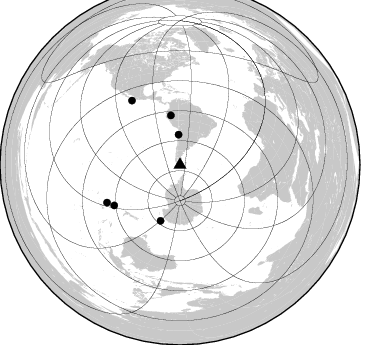
Nearby stations (2 deg radius)
| Station | Name | (Lat, Lon) | Start / End | Elevation |
| VTDF | Estancia Vicunna, Tierra del Fuego | (-54.14, -68.71) | 1997-02-07 / 2000-12-31 | 115 m |
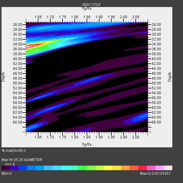
| Crust2 Type: | T6,Margin /shield transition, 1 km seds. |
| Thickness Estimate: | 35 km |
| Thickness StdDev: | 3.5 km |
| Vp/Vs Estimate: | 1.60 |
| Vp/Vs StdDev: | 0.02 |
| Vs Estimate: | 4.045 km/s |
| Poisson's Ratio: | 0.18 |
| Peak Value: | 0.03 |
| Assumed Vp: | 6.472 km/s |
| Ps Weight: | 0.33333334 |
| PpPs Weight: | 0.33333334 |
| PsPs Weight: | 0.33333328 |
| Residual Complexity: | 0.584 |
| Nearby stations H: | +- |
| (2.0 deg) Vp/Vs: | +- |
1 with match > 90% ( 11.111111 %) and 6 with match > 80% ( 66.666664 %) out of 9.
Download stack as xyz text file.
Azimuth Distribution of Events:
Prior Results for this Station
| Study | Thickness | Vp/Vs | Vp | Vs | Poissons Ratio | Extra |
| EARS | 35 km | 1.60 | 6.472 km/s | 4.045 km/s | 0.18 | |
| Crust2.0 | 32 km | 1.79 | 6.472 km/s | 3.622 km/s | 0.27 | T6,Margin /shield transition, 1 km seds. |
| Global Maxima | 35 km | 1.60 | 6.472 km/s | 4.045 km/s | 0.18 | amp=0.030105457 |
| Local Maxima 1 | 36 km | 1.66 | 6.472 km/s | 3.893 km/s | 0.22 | amp=0.012768743 |
| Local Maxima 2 | 34 km | 1.60 | 6.472 km/s | 4.045 km/s | 0.18 | amp=0.01193914 |
| Local Maxima 3 | 27 km | 1.67 | 6.472 km/s | 3.881 km/s | 0.22 | amp=0.007935948 |
| Local Maxima 4 | 68 km | 1.62 | 6.472 km/s | 4.001 km/s | 0.19 | amp=0.0054646027 |
| Predicted Arrivals for vertical incidence (zero ray parameter) | |
| Ps | 3.27 SECOND |
| PpPs | 14.16 SECOND |
| PsPs/PpSs | 17.43 SECOND |
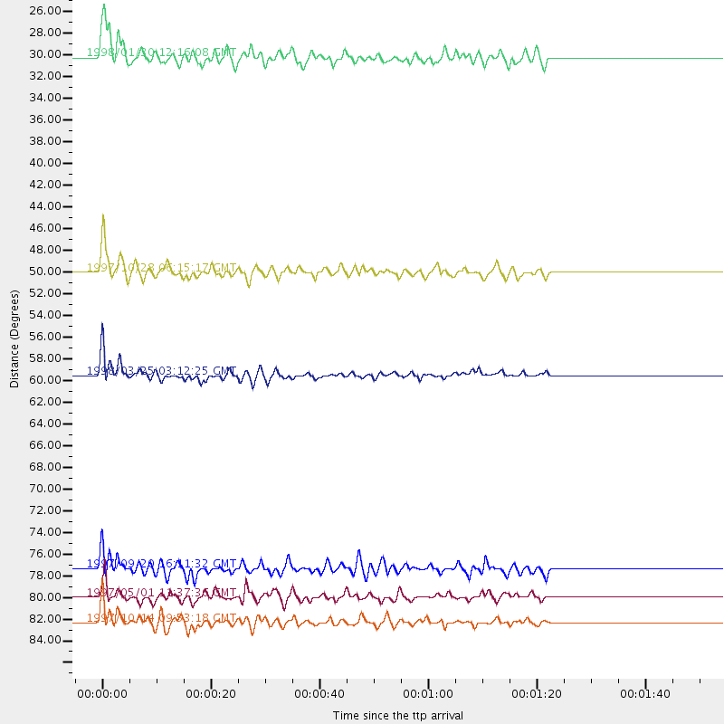
Events Processed for this Station
Download zip of receiver functions as SAC
Plot maxima for each earthquake.
Events Used in the Stack
(6 events)| Radial Match | Distance | Baz | FERegion | Time | Lat/Lon | Depth | Magnitude |
| 90.57358 | 59.5 deg | 199.21 deg | Balleny Islands Region | 1998/03/25 03:12:25 GMT | (-62.9, 149.5) | 10 km | 6.6 MB, 8.0 MS, 8.3 UNKNOWN, 8.1 MW |
| 89.81885 | 50.0 deg | 349.602 deg | Northern Peru | 1997/10/28 06:15:17 GMT | (-4.4, -76.7) | 112 km | 6.6 MB, 6.3 MS, 7.2 UNKNOWN, 6.6 ME |
| 88.038765 | 82.3 deg | 242.824 deg | South Of Fiji Islands | 1997/10/14 09:53:18 GMT | (-22.1, -176.8) | 167 km | 6.7 MB, 7.7 UNKNOWN, 7.4 ME |
| 86.121086 | 77.4 deg | 238.403 deg | Kermadec Islands Region | 1997/09/20 16:11:32 GMT | (-28.7, -177.6) | 30 km | 6.1 MB, 7.0 MS, 7.2 UNKNOWN, 6.7 ME |
| 85.948326 | 30.2 deg | 357.269 deg | Near Coast Of Northern Chile | 1998/01/30 12:16:08 GMT | (-23.9, -70.2) | 42 km | 6.3 MB, 6.5 MS, 7.0 UNKNOWN, 6.7 ME |
| 81.56785 | 80.0 deg | 323.132 deg | Off Coast Of Jalisco, Mexico | 1997/05/01 11:37:36 GMT | (19.0, -107.3) | 33 km | 6.1 MB, 6.8 MS, 7.1 UNKNOWN, 7.1 ME |
Losers
(3 events)| Radial Match | Distance | Baz | FERegion | Time | Lat/Lon | Depth | Magnitude | Reason |
| 70.93428 | 32.8 deg | 287.707 deg | Southern East Pacific Rise | 1997/06/10 21:53:55 GMT | (-35.8, -108.1) | 10 km | 5.8 MB, 6.1 MS, 6.5 UNKNOWN, 5.8 MS | |
| 69.16244 | 81.1 deg | 236.578 deg | South Of Fiji Islands | 1997/09/04 04:23:37 GMT | (-26.6, 178.3) | 625 km | 6.3 MB, 6.8 UNKNOWN, 6.5 ME | |
| 45.079784 | 87.2 deg | 247.915 deg | Tonga Islands | 1997/08/04 18:53:58 GMT | (-15.2, -175.3) | 33 km | 5.5 MB, 6.0 MS, 6.1 UNKNOWN, 6.0 MW |
