
Station XC Y37 - Y37
Network: XC00 - Yellowstone Intermountain Seismic Array
Nearby stations (2 deg radius)

| Station | Name | (Lat, Lon) | Start / End | Elevation |
| Y37 | Y37 | (46.18, -112.03) | 2000-07-16 / 2001-12-31 | 1454 m |
| Crust2 Type: | PE,orogen/50km, Tibet, 0.5 km seds. |
| Thickness Estimate: | 35 km |
| Thickness StdDev: | 0.5 km |
| Vp/Vs Estimate: | 1.77 |
| Vp/Vs StdDev: | 0.04 |
| Vs Estimate: | 3.584 km/s |
| Poisson's Ratio: | 0.27 |
| Peak Value: | 0.03 |
| Assumed Vp: | 6.353 km/s |
| Ps Weight: | 0.33333334 |
| PpPs Weight: | 0.33333334 |
| PsPs Weight: | 0.33333328 |
| Residual Complexity: | 0.354 |
| Nearby stations H: | +- |
| (2.0 deg) Vp/Vs: | +- |
4 with match > 90% ( 30.76923 %) and 13 with match > 80% ( 100.0 %) out of 13.
Download stack as xyz text file.
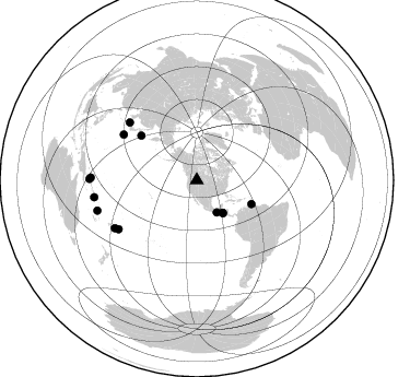
Azimuth Distribution of Events:
Prior Results for this Station
| Study | Thickness | Vp/Vs | Vp | Vs | Poissons Ratio | Extra |
| EARS | 35 km | 1.77 | 6.353 km/s | 3.584 km/s | 0.27 | |
| Crust2.0 | 50 km | 1.76 | 6.353 km/s | 3.612 km/s | 0.26 | PE,orogen/50km, Tibet, 0.5 km seds. |
| Global Maxima | 35 km | 1.77 | 6.353 km/s | 3.584 km/s | 0.27 | amp=0.026316669 |
| Local Maxima 1 | 34 km | 1.69 | 6.353 km/s | 3.754 km/s | 0.23 | amp=0.009550575 |
| Local Maxima 2 | 37 km | 1.70 | 6.353 km/s | 3.732 km/s | 0.24 | amp=0.0063544805 |
| Local Maxima 3 | 26 km | 1.64 | 6.353 km/s | 3.862 km/s | 0.21 | amp=0.004334074 |
| Local Maxima 4 | 26 km | 1.89 | 6.353 km/s | 3.366 km/s | 0.30 | amp=0.003758364 |
| Predicted Arrivals for vertical incidence (zero ray parameter) | |
| Ps | 4.23 SECOND |
| PpPs | 15.17 SECOND |
| PsPs/PpSs | 19.39 SECOND |
Events Processed for this Station
Download zip of receiver functions as SAC
Plot maxima for each earthquake.
Events Used in the Stack
(13 events)| Radial Match | Distance | Baz | FERegion | Time | Lat/Lon | Depth | Magnitude |
| 93.63921 | 38.5 deg | 141.586 deg | El Salvador | 2001/01/13 17:33:32 GMT | (13.0, -88.7) | 60 km | 6.4 MB, 7.8 MS, 7.7 MW, 7.5 ME |
| 93.61353 | 65.3 deg | 308.786 deg | Kuril Islands | 2001/05/25 00:40:50 GMT | (44.3, 148.4) | 33 km | 6.1 MB, 6.7 MS, 6.7 MW, 6.6 MW |
| 90.63606 | 37.8 deg | 141.535 deg | El Salvador | 2001/02/13 14:22:05 GMT | (13.7, -88.9) | 10 km | 5.5 MB, 6.5 MS, 6.6 MW, 6.1 MD |
| 90.12372 | 84.2 deg | 237.957 deg | Tonga Islands | 2000/09/26 06:17:52 GMT | (-17.2, -173.9) | 56 km | 6.1 MB, 6.1 MS, 6.4 MW, 6.1 ME |
| 89.98486 | 96.9 deg | 271.421 deg | New Ireland Region, P.N.G. | 2000/11/16 04:54:56 GMT | (-4.0, 152.2) | 33 km | 6.0 MB, 8.2 MS, 8.0 MW, 8.0 ME |
| 88.668594 | 54.5 deg | 113.573 deg | Windward Islands | 2000/10/04 14:37:44 GMT | (11.1, -62.6) | 110 km | 5.6 MB, 5.4 MS, 6.1 MW, 5.9 MD |
| 85.24497 | 98.2 deg | 270.641 deg | New Britain Region, P.N.G. | 2000/11/17 21:01:56 GMT | (-5.5, 151.8) | 33 km | 6.2 MB, 8.0 MS, 7.6 MW, 6.9 ME |
| 84.52479 | 81.2 deg | 310.673 deg | Western Honshu, Japan | 2001/03/24 06:27:53 GMT | (34.1, 132.5) | 50 km | 6.4 MB, 6.5 MS, 6.8 MW, 6.4 ME |
| 82.34615 | 86.6 deg | 239.658 deg | Fiji Islands Region | 2001/04/28 04:49:53 GMT | (-18.1, -176.9) | 352 km | 6.2 MB, 6.8 MW, 6.8 MW |
| 81.60931 | 79.0 deg | 302.025 deg | Southeast Of Honshu, Japan | 2001/04/14 23:27:26 GMT | (30.1, 141.8) | 10 km | 6.0 MB, 5.8 MS, 6.0 MW, 6.0 ME |
| 81.604034 | 94.9 deg | 252.994 deg | Vanuatu Islands | 2000/10/04 16:58:44 GMT | (-15.4, 166.9) | 23 km | 6.1 MB, 6.9 MS, 6.8 MW, 6.5 ME |
| 80.68215 | 34.7 deg | 148.181 deg | Near Coast Of Chiapas, Mexico | 2000/12/04 04:43:09 GMT | (14.9, -93.9) | 33 km | 5.6 MB, 5.7 MS, 6.0 MW, 5.9 MW |
| 80.05792 | 95.1 deg | 260.528 deg | Solomon Islands | 2001/05/09 17:38:26 GMT | (-10.3, 161.2) | 68 km | 6.0 MB, 5.9 MS, 6.3 MW, 6.2 MW |
Losers
(0 events)| Radial Match | Distance | Baz | FERegion | Time | Lat/Lon | Depth | Magnitude | Reason |
