
Station XC Y62 - Y62
Network: XC00 - Yellowstone Intermountain Seismic Array
Nearby stations (2 deg radius)
| Station | Name | (Lat, Lon) | Start / End | Elevation |
| Y62 | Y62 | (46.17, -110.56) | 2000-07-10 / 2001-12-31 | 1797 m |
| Crust2 Type: | P4,orogen/50km, Urals, Tethian Orogen, Rockies 1 km seds. |
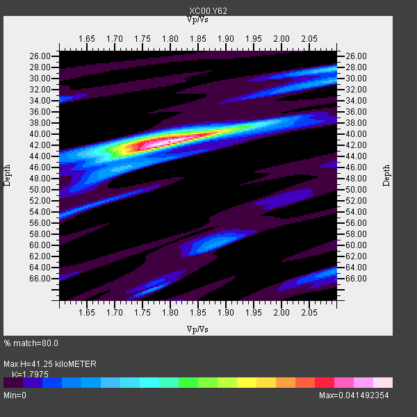
| Thickness Estimate: | 41 km |
| Thickness StdDev: | 10 km |
| Vp/Vs Estimate: | 1.80 |
| Vp/Vs StdDev: | 0.01 |
| Vs Estimate: | 3.508 km/s |
| Poisson's Ratio: | 0.28 |
| Peak Value: | 0.04 |
| Assumed Vp: | 6.306 km/s |
| Ps Weight: | 0.33333334 |
| PpPs Weight: | 0.33333334 |
| PsPs Weight: | 0.33333328 |
| Residual Complexity: | 0.403 |
| Nearby stations H: | +- |
| (2.0 deg) Vp/Vs: | +- |
0 with match > 90% ( 0.0 %) and 2 with match > 80% ( 100.0 %) out of 2.
Download stack as xyz text file.
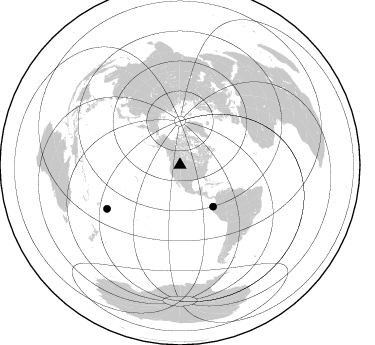
Azimuth Distribution of Events:
Prior Results for this Station
| Study | Thickness | Vp/Vs | Vp | Vs | Poissons Ratio | Extra |
| EARS | 41 km | 1.80 | 6.306 km/s | 3.508 km/s | 0.28 | |
| Crust2.0 | 50 km | 1.76 | 6.306 km/s | 3.584 km/s | 0.26 | P4,orogen/50km, Urals, Tethian Orogen, Rockies 1 km seds. |
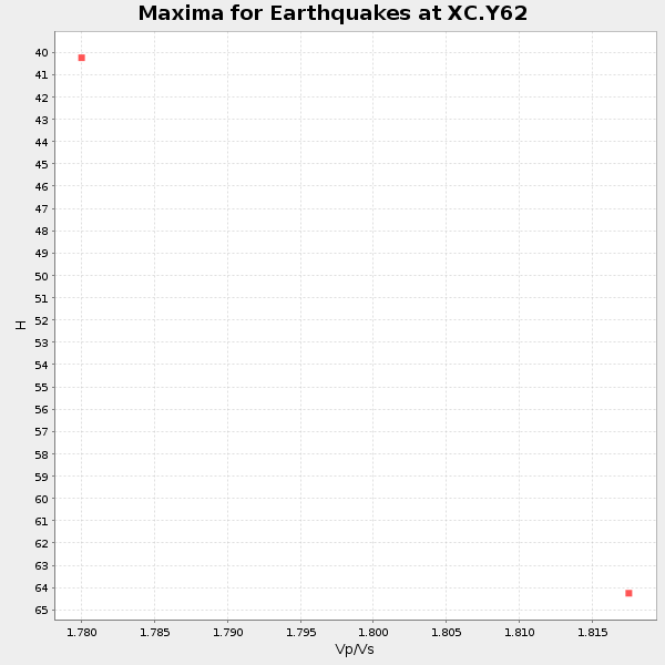
| Global Maxima | 41 km | 1.80 | 6.306 km/s | 3.508 km/s | 0.28 | amp=0.041492354 |
| Local Maxima 1 | 41 km | 1.76 | 6.306 km/s | 3.588 km/s | 0.26 | amp=0.017487641 |
| Local Maxima 2 | 28 km | 2.10 | 6.306 km/s | 3.006 km/s | 0.35 | amp=0.012652848 |
| Local Maxima 3 | 60 km | 1.88 | 6.306 km/s | 3.359 km/s | 0.30 | amp=0.009435759 |
| Local Maxima 4 | 64 km | 2.10 | 6.306 km/s | 3.006 km/s | 0.35 | amp=0.009087338 |
| Predicted Arrivals for vertical incidence (zero ray parameter) | |
| Ps | 5.22 SECOND |
| PpPs | 18.30 SECOND |
| PsPs/PpSs | 23.52 SECOND |
Events Processed for this Station
Download zip of receiver functions as SAC
Plot maxima for each earthquake.
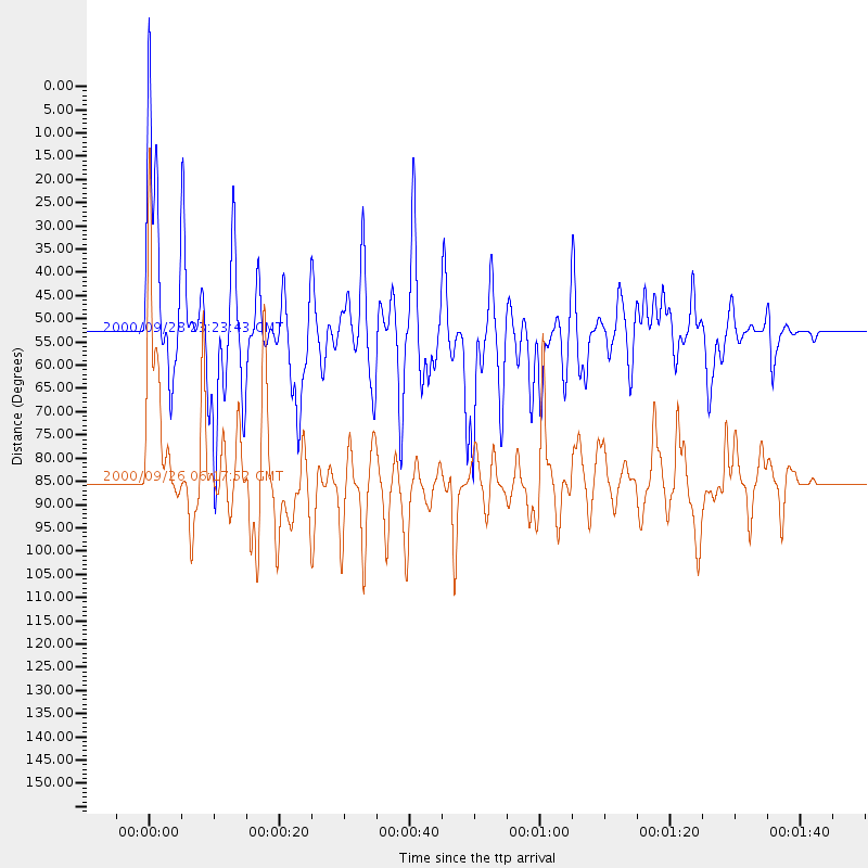
Events Used in the Stack
(2 events)| Radial Match | Distance | Baz | FERegion | Time | Lat/Lon | Depth | Magnitude |
| 88.35354 | 85.0 deg | 239.068 deg | Tonga Islands | 2000/09/26 06:17:52 GMT | (-17.2, -173.9) | 56 km | 6.1 MB, 6.1 MS, 6.4 MW, 6.1 ME |
| 81.57034 | 53.2 deg | 141.386 deg | Near Coast Of Ecuador | 2000/09/28 23:23:43 GMT | (-0.2, -80.6) | 23 km | 5.8 MB, 6.0 MS, 6.6 MW, 6.4 MW |
Losers
(0 events)| Radial Match | Distance | Baz | FERegion | Time | Lat/Lon | Depth | Magnitude | Reason |
