
Station XC STIL - Stillwater Hill
Network: XC94 - Puget Sound BB Array
Nearby stations (2 deg radius)
| Station | Name | (Lat, Lon) | Start / End | Elevation |
| STIL | Stillwater Hill | (47.70, -121.91) | 1994-02-12 / 1994-12-31 | 116 m |
| Crust2 Type: | L3,continental arc, Southern Andes, 0.2 km seds. |
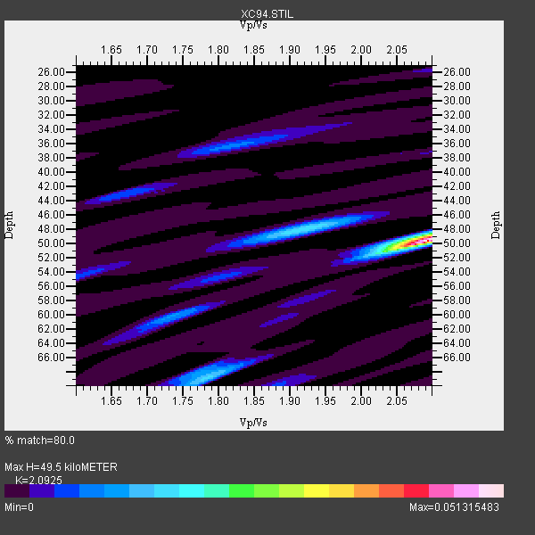
| Thickness Estimate: | 50 km |
| Thickness StdDev: | 8.1 km |
| Vp/Vs Estimate: | 2.09 |
| Vp/Vs StdDev: | 0.15 |
| Vs Estimate: | 3.153 km/s |
| Poisson's Ratio: | 0.35 |
| Peak Value: | 0.05 |
| Assumed Vp: | 6.597 km/s |
| Ps Weight: | 0.33333334 |
| PpPs Weight: | 0.33333334 |
| PsPs Weight: | 0.33333328 |
| Residual Complexity: | 0.583 |
| Nearby stations H: | +- |
| (2.0 deg) Vp/Vs: | +- |
0 with match > 90% ( 0.0 %) and 5 with match > 80% ( 33.333332 %) out of 15.
Download stack as xyz text file.
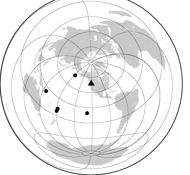
Azimuth Distribution of Events:
Prior Results for this Station
| Study | Thickness | Vp/Vs | Vp | Vs | Poissons Ratio | Extra |
| EARS | 50 km | 2.09 | 6.597 km/s | 3.153 km/s | 0.35 | |
| Crust2.0 | 40 km | 1.77 | 6.597 km/s | 3.723 km/s | 0.27 | L3,continental arc, Southern Andes, 0.2 km seds. |
| Global Maxima | 50 km | 2.09 | 6.597 km/s | 3.153 km/s | 0.35 | amp=0.051315483 |
| Local Maxima 1 | 48 km | 1.91 | 6.597 km/s | 3.45 km/s | 0.31 | amp=0.017384222 |
| Local Maxima 2 | 69 km | 1.78 | 6.597 km/s | 3.701 km/s | 0.27 | amp=0.014032554 |
| Local Maxima 3 | 36 km | 1.82 | 6.597 km/s | 3.63 km/s | 0.28 | amp=0.00865047 |
| Local Maxima 4 | 43 km | 1.66 | 6.597 km/s | 3.98 km/s | 0.21 | amp=0.00619145 |
| Predicted Arrivals for vertical incidence (zero ray parameter) | |
| Ps | 8.20 SECOND |
| PpPs | 23.20 SECOND |
| PsPs/PpSs | 31.40 SECOND |
Events Processed for this Station
Download zip of receiver functions as SAC
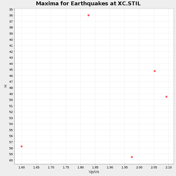
Plot maxima for each earthquake.
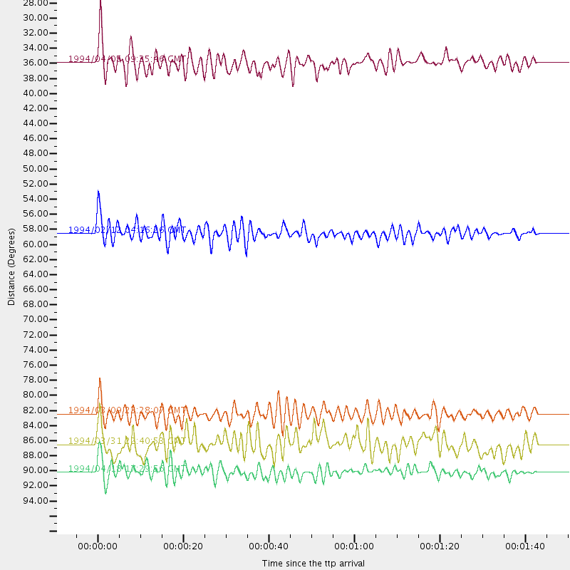
Events Used in the Stack
(5 events)| Radial Match | Distance | Baz | FERegion | Time | Lat/Lon | Depth | Magnitude |
| 88.86045 | 82.5 deg | 233.356 deg | Fiji Islands Region | 1994/03/09 23:28:07 GMT | (-17.8, -178.5) | 564 km | 6.6 MB, 7.6 UNKNOWN, 7.6 MW |
| 85.15095 | 58.5 deg | 187.976 deg | South Pacific Ocean | 1994/02/12 04:16:26 GMT | (-10.8, -128.8) | 10 km | 6.3 MB, 6.5 MS, 6.6 UNKNOWN, 6.6 MW |
| 83.72078 | 35.9 deg | 297.221 deg | Andreanof Islands, Aleutian Is. | 1994/04/05 09:35:46 GMT | (51.3, -178.1) | 33 km | 5.8 MB, 5.9 MS, 6.2 UNKNOWN, 6.0 MW |
| 81.19729 | 86.5 deg | 231.809 deg | Fiji Islands Region | 1994/03/31 22:40:53 GMT | (-22.0, -179.6) | 591 km | 5.9 MB, 6.5 UNKNOWN, 6.5 MW |
| 80.79665 | 90.2 deg | 260.627 deg | Solomon Islands | 1994/04/18 17:29:56 GMT | (-6.5, 154.9) | 43 km | 6.6 MB, 6.7 MS, 6.8 UNKNOWN, 6.7 MW |
Losers
(10 events)| Radial Match | Distance | Baz | FERegion | Time | Lat/Lon | Depth | Magnitude | Reason |
| 79.070114 | 87.8 deg | 246.338 deg | Vanuatu Islands | 1994/04/23 15:00:53 GMT | (-14.1, 167.5) | 11 km | 6.0 MB, 6.0 MS, 6.2 UNKNOWN, 6.2 MW | |
| 70.62553 | 46.2 deg | 130.706 deg | Off Coast Of Central America | 1994/03/15 03:36:21 GMT | (11.2, -88.0) | 23 km | 5.8 MB, 5.5 MS, 5.4 UNKNOWN, 5.6 MD | |
| 68.69595 | 77.8 deg | 230.292 deg | Tonga Islands | 1994/04/04 01:37:03 GMT | (-15.5, -173.2) | 33 km | 5.8 MB, 5.5 MS | |
| 68.00878 | 91.6 deg | 240.866 deg | Vanuatu Islands | 1994/02/12 17:58:25 GMT | (-20.6, 169.4) | 33 km | 6.3 MB, 7.2 MS, 7.2 UNKNOWN, 7.0 MW | |
| 67.32583 | 90.1 deg | 261.763 deg | Solomon Islands | 1994/04/21 03:51:44 GMT | (-5.7, 154.1) | 30 km | 5.8 MB, 6.6 MS, 6.7 UNKNOWN, 6.6 MW | |
| 63.086483 | 88.6 deg | 302.802 deg | Southeast Of Taiwan | 1994/04/13 04:00:51 GMT | (22.7, 123.6) | 36 km | 5.7 MB, 5.6 MS, 5.8 UNKNOWN | |
| 54.11419 | 85.6 deg | 231.564 deg | Fiji Islands Region | 1994/04/18 21:39:43 GMT | (-21.4, -178.8) | 541 km | 5.5 MB | |
| 54.074387 | 79.8 deg | 234.121 deg | Fiji Islands Region | 1994/04/02 15:34:44 GMT | (-15.1, -177.6) | 354 km | 5.5 MB | |
| 44.40161 | 91.7 deg | 241.331 deg | Loyalty Islands | 1994/02/18 13:41:31 GMT | (-20.4, 168.9) | 33 km | 5.4 MB, 5.7 MS, 5.6 UNKNOWN, 6.0 MW | |
| 42.924538 | 80.0 deg | 230.255 deg | Tonga Islands | 1994/02/24 15:25:35 GMT | (-17.4, -174.4) | 124 km | 5.6 MB |
