
Station XD PMC02 - PASSCAL McMurdo 02
Network: XD07 - Polar Equipment Development
Nearby stations (2 deg radius)
| Station | Name | (Lat, Lon) | Start / End | Elevation |
| PMC02 | PASSCAL McMurdo 02 | (-77.00, 166.68) | 2008-02-09 / 2010-12-31 | 0.1 km |
| Crust2 Type: | S1,continental slope, margin, transition 1 km seds. |
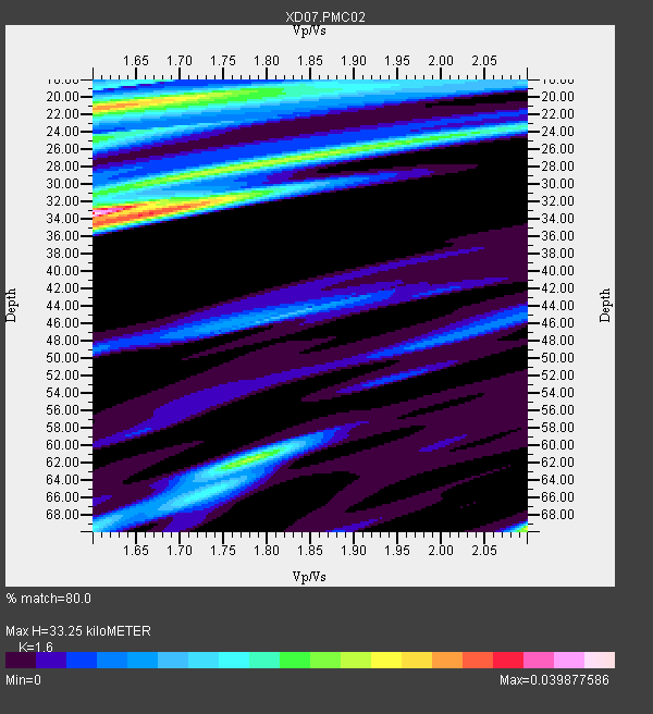
| Thickness Estimate: | 33 km |
| Thickness StdDev: | 5.6 km |
| Vp/Vs Estimate: | 1.60 |
| Vp/Vs StdDev: | 0.06 |
| Vs Estimate: | 3.864 km/s |
| Poisson's Ratio: | 0.18 |
| Peak Value: | 0.04 |
| Assumed Vp: | 6.183 km/s |
| Ps Weight: | 0.33333334 |
| PpPs Weight: | 0.33333334 |
| PsPs Weight: | 0.33333328 |
| Residual Complexity: | 0.828 |
| Nearby stations H: | +- |
| (2.0 deg) Vp/Vs: | +- |
1 with match > 90% ( 3.5714285 %) and 3 with match > 80% ( 10.714286 %) out of 28.
Download stack as xyz text file.
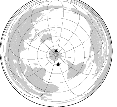
Azimuth Distribution of Events:
Prior Results for this Station
| Study | Thickness | Vp/Vs | Vp | Vs | Poissons Ratio | Extra |
| EARS | 33 km | 1.60 | 6.183 km/s | 3.864 km/s | 0.18 | |
| Crust2.0 | 23 km | 1.81 | 6.183 km/s | 3.422 km/s | 0.28 | S1,continental slope, margin, transition 1 km seds. |
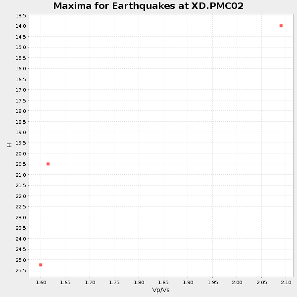
| Global Maxima | 33 km | 1.60 | 6.183 km/s | 3.864 km/s | 0.18 | amp=0.039877586 |
| Local Maxima 1 | 21 km | 1.60 | 6.183 km/s | 3.864 km/s | 0.18 | amp=0.029491913 |
| Local Maxima 2 | 70 km | 2.10 | 6.183 km/s | 2.948 km/s | 0.35 | amp=0.024253152 |
| Local Maxima 3 | 62 km | 1.78 | 6.183 km/s | 3.473 km/s | 0.27 | amp=0.02249556 |
| Local Maxima 4 | 27 km | 1.83 | 6.183 km/s | 3.378 km/s | 0.29 | amp=0.02244232 |
| Predicted Arrivals for vertical incidence (zero ray parameter) | |
| Ps | 3.23 SECOND |
| PpPs | 13.98 SECOND |
| PsPs/PpSs | 17.21 SECOND |
Events Processed for this Station
Download zip of receiver functions as SAC
Plot maxima for each earthquake.
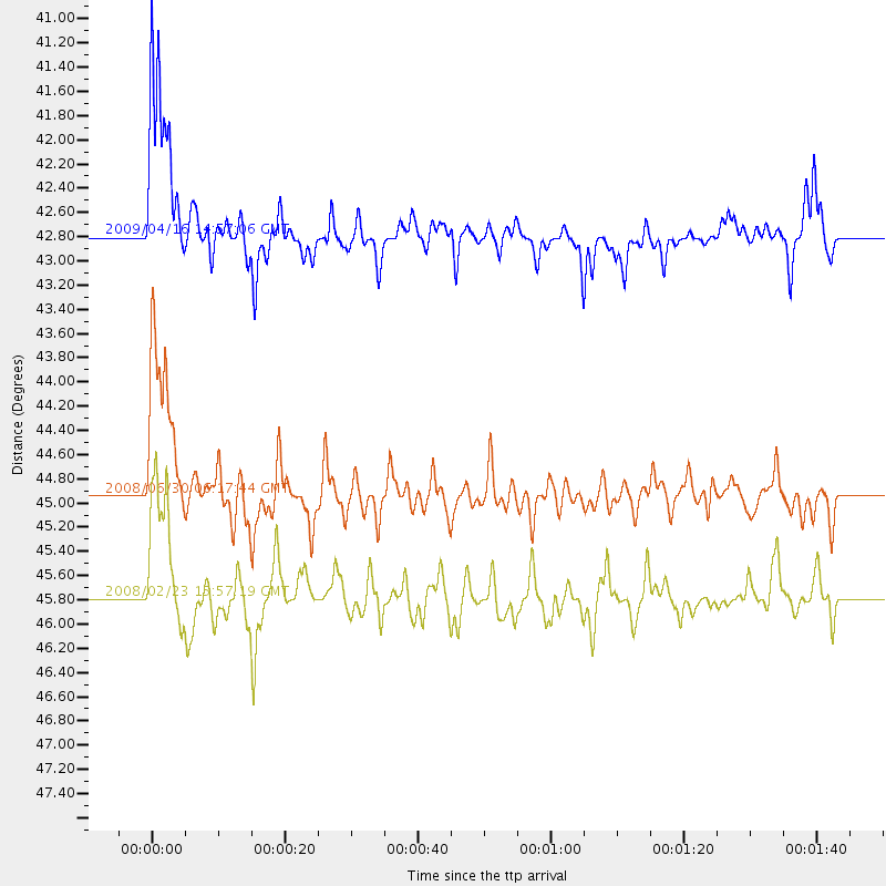
Events Used in the Stack
(3 events)| Radial Match | Distance | Baz | FERegion | Time | Lat/Lon | Depth | Magnitude |
| 90.649445 | 44.9 deg | 173.428 deg | South Sandwich Islands Region | 2008/06/30 06:17:44 GMT | (-58.2, -22.1) | 19 km | 6.1 MB, 6.7 MS, 7.0 MW, 6.9 MW |
| 88.602066 | 42.8 deg | 170.085 deg | South Sandwich Islands Region | 2009/04/16 14:57:06 GMT | (-60.2, -26.9) | 20 km | 6.2 MB, 6.8 MS, 6.7 MW, 6.7 MW |
| 85.78813 | 45.8 deg | 172.368 deg | South Sandwich Islands Region | 2008/02/23 15:57:19 GMT | (-57.3, -23.4) | 10 km | 6.2 MB, 6.7 MS, 6.7 MW, 6.7 MW |
Losers
(25 events)| Radial Match | Distance | Baz | FERegion | Time | Lat/Lon | Depth | Magnitude | Reason |
| 79.564644 | 73.0 deg | 311.414 deg | Flores Region, Indonesia | 2008/06/03 17:31:32 GMT | (-8.2, 120.3) | 14 km | 5.6 MB, 5.3 MS, 5.9 MW, 5.9 MW | |
| 78.64198 | 49.4 deg | 262.464 deg | Mid-Indian Ridge | 2008/05/31 04:37:56 GMT | (-41.2, 80.5) | 10 km | 6.0 MB, 6.3 MS, 6.4 MW, 6.4 MW | |
| 65.972305 | 95.4 deg | 107.405 deg | Off Coast Of Ecuador | 2009/05/10 01:16:06 GMT | (1.4, -85.2) | 6.0 km | 5.5 MB, 5.7 MS, 6.1 MW, 6.1 MW | |
| 65.4369 | 56.8 deg | 17.966 deg | Fiji Islands Region | 2009/02/11 09:31:04 GMT | (-20.8, -177.3) | 10 km | 5.5 MB, 5.2 MS, 5.5 MW, 5.5 MW | |
| 65.42856 | 80.6 deg | 293.163 deg | Southern Sumatra, Indonesia | 2008/05/21 22:22:55 GMT | (-4.1, 101.3) | 19 km | 5.5 MB, 5.2 MS, 5.5 MW, 5.4 MW | |
| 64.4563 | 53.7 deg | 95.55 deg | Southern East Pacific Rise | 2008/06/15 08:37:17 GMT | (-36.6, -107.4) | 10 km | 5.5 MB, 5.4 MS, 6.0 MW, 6.0 MW | |
| 62.34951 | 72.3 deg | 344.466 deg | New Britain Region, P.N.G. | 2009/03/24 23:28:27 GMT | (-5.1, 151.8) | 36 km | 5.6 MB, 5.4 MS, 5.8 MW, 5.8 MW | |
| 61.090908 | 83.8 deg | 319.591 deg | Talaud Islands, Indonesia | 2009/02/13 21:26:36 GMT | (3.8, 126.5) | 32 km | 5.5 MB, 5.2 MW | |
| 60.749912 | 45.1 deg | 170.865 deg | South Sandwich Islands Region | 2008/05/15 14:23:28 GMT | (-57.9, -25.5) | 35 km | 5.9 MB, 5.7 MS, 5.9 MW, 5.9 MW | |
| 60.202995 | 62.7 deg | 21.823 deg | Tonga Islands | 2009/03/06 07:01:48 GMT | (-15.2, -173.3) | 3.0 km | 5.5 MB, 5.4 MS, 5.8 MW, 5.8 MW | |
| 59.8246 | 53.7 deg | 220.461 deg | Prince Edward Islands Region | 2009/06/04 17:25:25 GMT | (-45.8, 35.1) | 16 km | 5.5 MB, 5.7 MS, 6.0 MW, 6.0 MW | |
| 56.933884 | 83.8 deg | 319.686 deg | Talaud Islands, Indonesia | 2009/03/16 14:15:56 GMT | (3.8, 126.6) | 35 km | 6.2 MB, 6.0 MS, 6.3 MW, 6.3 MW | |
| 56.728428 | 90.4 deg | 288.957 deg | Northern Sumatra, Indonesia | 2008/05/13 10:29:19 GMT | (4.7, 95.1) | 35 km | 5.6 MB, 5.1 MS, 5.4 MW, 5.4 MW | |
| 55.111187 | 58.6 deg | 231.99 deg | Southwest Indian Ridge | 2008/04/01 11:05:23 GMT | (-38.9, 46.3) | 10 km | 5.5 MB, 5.4 MW | |
| 54.634197 | 78.7 deg | 293.405 deg | Southwest Of Sumatra, Indonesia | 2009/04/01 06:29:40 GMT | (-6.0, 101.9) | 35 km | 5.6 MW, 5.2 MS, 5.3 MB | |
| 54.491478 | 66.3 deg | 355.205 deg | Solomon Islands | 2009/05/01 06:03:05 GMT | (-10.8, 162.2) | 21 km | 5.9 MB, 5.6 MS, 5.9 MW, 5.9 MW | |
| 51.370163 | 45.0 deg | 173.584 deg | East Of South Sandwich Islands | 2008/07/01 01:54:41 GMT | (-58.1, -21.9) | 10 km | 5.7 MB, 5.1 MS, 5.6 MW, 5.6 MW | |
| 45.214947 | 77.9 deg | 125.893 deg | Near Coast Of Northern Chile | 2009/04/17 02:08:08 GMT | (-19.6, -70.5) | 25 km | 5.8 MB, 5.8 MS, 6.1 MW, 6.1 MW | |
| 43.39245 | 66.2 deg | 359.294 deg | Santa Cruz Islands | 2009/04/21 21:09:59 GMT | (-10.8, 166.0) | 35 km | 5.7 MW, 5.0 MS, 5.3 MB, 5.7 MW | |
| 43.101517 | 54.1 deg | 15.4 deg | South Of Fiji Islands | 2008/07/03 03:02:37 GMT | (-23.4, -179.8) | 581 km | 5.6 MB, 6.2 MW, 6.2 MW | |
| 42.127705 | 80.6 deg | 255.986 deg | Mid-Indian Ridge | 2009/05/12 12:38:30 GMT | (-12.4, 65.1) | 10 km | 5.5 MB, 5.3 MS, 5.8 MW, 5.8 MW | |
| 41.485756 | 60.0 deg | 88.424 deg | Easter Island Region | 2008/05/31 23:16:04 GMT | (-28.9, -112.3) | 10 km | 5.5 MS, 5.4 MB, 5.8 MW, 5.8 MW | |
| 40.827873 | 70.6 deg | 131.179 deg | Catamarca Province, Argentina | 2009/04/03 17:54:50 GMT | (-27.8, -66.6) | 174 km | 5.7 MW, 5.3 MB, 5.7 MW | |
| 37.543613 | 86.0 deg | 119.254 deg | Central Peru | 2008/07/01 00:17:33 GMT | (-10.4, -75.5) | 33 km | 5.5 MW, 5.0 MS, 5.4 MB, 5.3 ML | |
| 37.130917 | 70.8 deg | 346.8 deg | Solomon Islands | 2009/04/16 00:43:20 GMT | (-6.5, 154.2) | 10 km | 5.8 MS, 5.3 MB, 5.8 MW, 5.7 MW |
