
Station XD MITU - XD.MITU
Network: XD94 - Tanzania BB Experiment
Nearby stations (2 deg radius)
| Station | Name | (Lat, Lon) | Start / End | Elevation |
| MITU | XD.MITU | (-6.02, 34.06) | 1994-05-24 / 1995-05-17 | 1566 m |
| Crust2 Type: | IE,late Proter., no seds. |
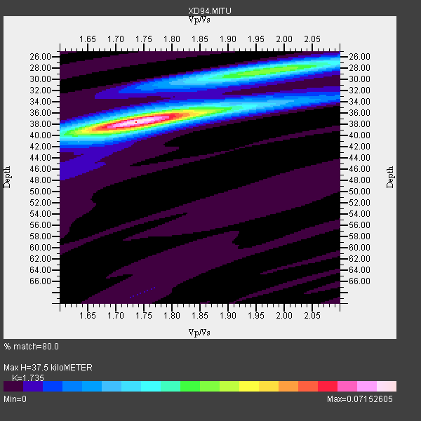
| Thickness Estimate: | 38 km |
| Thickness StdDev: | 0.2 km |
| Vp/Vs Estimate: | 1.74 |
| Vp/Vs StdDev: | 0.01 |
| Vs Estimate: | 3.833 km/s |
| Poisson's Ratio: | 0.25 |
| Peak Value: | 0.07 |
| Assumed Vp: | 6.65 km/s |
| Ps Weight: | 0.33333334 |
| PpPs Weight: | 0.33333334 |
| PsPs Weight: | 0.33333328 |
| Residual Complexity: | 0.493 |
| Nearby stations H: | +- |
| (2.0 deg) Vp/Vs: | +- |
13 with match > 90% ( 50.0 %) and 18 with match > 80% ( 69.23077 %) out of 26.
Download stack as xyz text file.
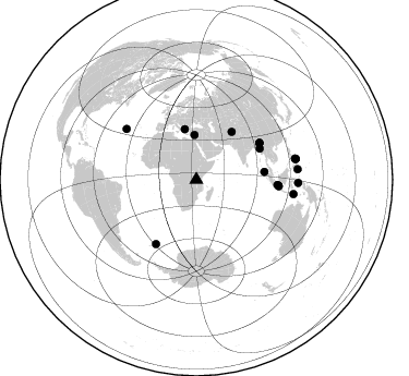
Azimuth Distribution of Events:
Prior Results for this Station
| Study | Thickness | Vp/Vs | Vp | Vs | Poissons Ratio | Extra |
| EARS | 38 km | 1.74 | 6.65 km/s | 3.833 km/s | 0.25 | |
| Crust2.0 | 36 km | 1.77 | 6.65 km/s | 3.758 km/s | 0.27 | IE,late Proter., no seds. |
| Global Maxima | 38 km | 1.74 | 6.65 km/s | 3.833 km/s | 0.25 | amp=0.07152605 |
| Local Maxima 1 | 28 km | 1.97 | 6.65 km/s | 3.38 km/s | 0.33 | amp=0.036392905 |
| Local Maxima 2 | 38 km | 1.75 | 6.65 km/s | 3.805 km/s | 0.26 | amp=0.016625704 |
| Local Maxima 3 | 38 km | 1.68 | 6.65 km/s | 3.958 km/s | 0.23 | amp=0.010904213 |
| Local Maxima 4 | 28 km | 1.98 | 6.65 km/s | 3.354 km/s | 0.33 | amp=0.009979325 |
| Predicted Arrivals for vertical incidence (zero ray parameter) | |
| Ps | 4.14 SECOND |
| PpPs | 15.42 SECOND |
| PsPs/PpSs | 19.57 SECOND |
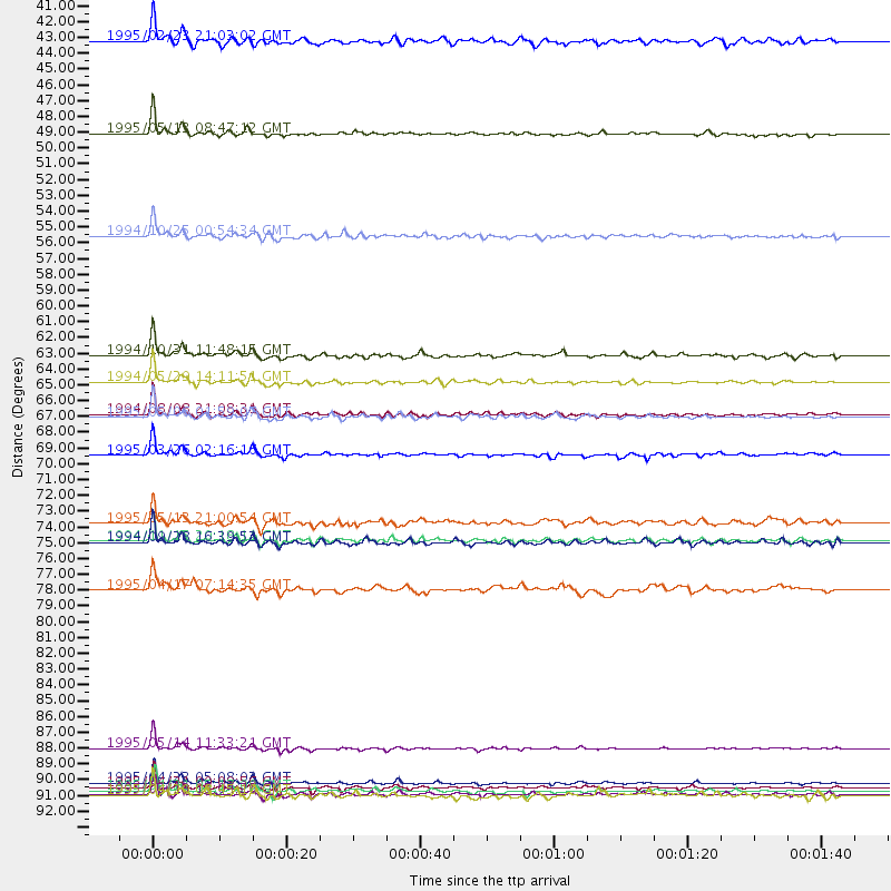
Events Processed for this Station
Download zip of receiver functions as SAC
Plot maxima for each earthquake.
Events Used in the Stack
(18 events)| Radial Match | Distance | Baz | FERegion | Time | Lat/Lon | Depth | Magnitude |
| 97.05822 | 92.8 deg | 78.301 deg | Samar, Philippines | 1995/04/21 00:09:56 GMT | (12.0, 125.7) | 33 km | 6.1 MB, 6.9 MS, 6.9 UNKNOWN, 6.8 MW |
| 96.911255 | 90.1 deg | 98.402 deg | Timor Region | 1995/05/14 11:33:21 GMT | (-8.4, 125.1) | 33 km | 6.1 MB, 6.9 MS, 7.1 UNKNOWN, 6.9 MW |
| 96.78412 | 47.3 deg | 347.092 deg | Greece | 1995/05/13 08:47:12 GMT | (40.1, 21.7) | 13 km | 6.2 MB, 6.5 MS, 6.6 UNKNOWN, 6.5 MD |
| 96.72602 | 64.6 deg | 64.038 deg | Myanmar | 1994/05/29 14:11:51 GMT | (20.5, 94.2) | 42 km | 6.2 MB, 6.2 MS, 5.9 UNKNOWN, 6.5 MW |
| 96.52709 | 67.1 deg | 59.777 deg | Myanmar-India Border Region | 1995/05/06 01:59:07 GMT | (25.0, 95.3) | 122 km | 6.4 MB, 6.5 UNKNOWN, 6.4 MW |
| 95.92627 | 69.7 deg | 212.151 deg | South Sandwich Islands Region | 1995/03/26 02:16:16 GMT | (-55.9, -28.2) | 77 km | 6.1 MB, 5.9 MS, 6.4 UNKNOWN, 6.3 MW |
| 92.59354 | 93.1 deg | 78.183 deg | Samar, Philippines | 1995/04/21 05:17:00 GMT | (12.1, 125.9) | 23 km | 5.6 MB, 6.9 MS, 6.7 UNKNOWN, 6.7 MW |
| 91.78765 | 66.9 deg | 60.039 deg | Myanmar | 1994/08/08 21:08:31 GMT | (24.7, 95.2) | 127 km | 6.0 MB, 5.1 UNKNOWN, 6.1 MW |
| 91.46433 | 93.3 deg | 91.698 deg | Halmahera, Indonesia | 1995/02/13 15:04:26 GMT | (-1.4, 127.5) | 33 km | 6.2 MB, 6.8 MS, 6.8 UNKNOWN, 6.7 MW |
| 91.31191 | 75.7 deg | 94.243 deg | Java Sea | 1994/11/15 20:18:11 GMT | (-5.6, 110.2) | 559 km | 6.2 MB, 6.5 UNKNOWN, 6.5 MW |
| 90.78861 | 62.8 deg | 83.493 deg | Northern Sumatra, Indonesia | 1994/10/31 11:48:15 GMT | (3.0, 96.3) | 46 km | 5.6 MB, 6.1 MS, 6.3 UNKNOWN, 6.2 MW |
| 90.579994 | 92.5 deg | 77.895 deg | Samar, Philippines | 1995/04/23 05:08:03 GMT | (12.4, 125.4) | 33 km | 6.0 MB, 6.6 MS, 6.7 UNKNOWN, 6.7 MW |
| 90.03644 | 75.8 deg | 94.424 deg | Java Sea | 1994/09/28 16:39:52 GMT | (-5.8, 110.3) | 643 km | 5.7 MB, 6.7 UNKNOWN, 6.6 MW |
| 88.27784 | 54.4 deg | 36.554 deg | Hindu Kush Region, Afghanistan | 1994/10/25 00:54:34 GMT | (36.3, 70.9) | 244 km | 5.9 MB, 6.2 UNKNOWN, 5.9 MW |
| 85.02799 | 40.9 deg | 357.755 deg | Cyprus Region | 1995/02/23 21:03:02 GMT | (35.0, 32.3) | 15 km | 5.8 MB, 5.7 MS, 5.9 UNKNOWN, 5.8 MW |
| 84.73452 | 93.4 deg | 84.066 deg | Mindanao, Philippines | 1995/04/20 08:45:10 GMT | (6.3, 126.8) | 85 km | 6.2 MB, 6.6 UNKNOWN, 6.5 MW |
| 84.397026 | 79.1 deg | 305.935 deg | Northern Mid-Atlantic Ridge | 1995/04/17 07:14:35 GMT | (33.8, -38.6) | 10 km | 5.8 MB, 5.8 MS, 5.9 UNKNOWN, 6.1 MW |
| 82.22568 | 74.4 deg | 93.732 deg | Java Sea | 1995/05/13 21:00:54 GMT | (-5.2, 108.9) | 554 km | 5.7 MB, 5.9 UNKNOWN, 5.8 MW |
Losers
(8 events)| Radial Match | Distance | Baz | FERegion | Time | Lat/Lon | Depth | Magnitude | Reason |
| 77.74079 | 54.6 deg | 321.724 deg | Strait Of Gibraltar | 1994/05/26 08:26:52 GMT | (35.4, -4.1) | 10 km | 5.7 MB, 5.8 MS, 5.9 UNKNOWN | |
| 77.3677 | 54.6 deg | 36.376 deg | Hindu Kush Region, Afghanistan | 1995/05/16 03:35:03 GMT | (36.5, 70.9) | 190 km | 5.7 MB, 5.9 UNKNOWN, 5.8 MW | |
| 73.08465 | 93.0 deg | 78.748 deg | Samar, Philippines | 1995/05/08 18:08:09 GMT | (11.6, 125.9) | 33 km | 5.6 MB, 6.2 MS, 6.3 UNKNOWN, 6.3 MW | |
| 64.244705 | 94.6 deg | 88.622 deg | Halmahera, Indonesia | 1995/05/04 02:18:51 GMT | (1.9, 128.5) | 55 km | 6.0 MB, 6.0 MS, 6.1 UNKNOWN, 6.1 MW | |
| 58.950302 | 93.4 deg | 97.709 deg | Banda Sea | 1995/01/19 09:55:34 GMT | (-7.3, 128.3) | 170 km | 5.8 MB, 6.1 UNKNOWN, 5.9 MW | |
| 57.889782 | 92.7 deg | 85.077 deg | Mindanao, Philippines | 1995/02/19 00:17:48 GMT | (5.2, 126.2) | 104 km | 5.9 MB, 6.1 UNKNOWN, 6.1 MW | |
| 57.68118 | 93.5 deg | 84.213 deg | Mindanao, Philippines | 1995/04/04 17:21:04 GMT | (6.2, 127.0) | 86 km | 5.5 MB | |
| 56.936424 | 91.6 deg | 33.31 deg | East Of Lake Baykal, Russia | 1994/08/21 15:56:01 GMT | (56.7, 117.8) | 33 km | 5.7 MB, 5.8 MS, 6.0 UNKNOWN, 6.0 MW |
