
Station XD MTAN - XD.MTAN
Network: XD94 - Tanzania BB Experiment
Nearby stations (2 deg radius)
| Station | Name | (Lat, Lon) | Start / End | Elevation |
| MTAN | XD.MTAN | (-7.91, 33.32) | 1994-05-25 / 1994-10-31 | 1393 m |
| Crust2 Type: | GE,Archean, no seds. |
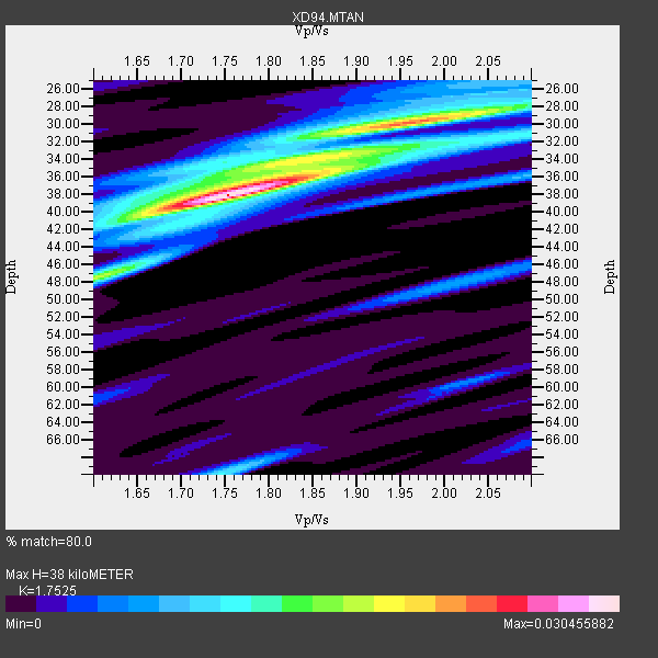
| Thickness Estimate: | 38 km |
| Thickness StdDev: | 12 km |
| Vp/Vs Estimate: | 1.75 |
| Vp/Vs StdDev: | 0.09 |
| Vs Estimate: | 3.684 km/s |
| Poisson's Ratio: | 0.26 |
| Peak Value: | 0.03 |
| Assumed Vp: | 6.455 km/s |
| Ps Weight: | 0.33333334 |
| PpPs Weight: | 0.33333334 |
| PsPs Weight: | 0.33333328 |
| Residual Complexity: | 0.694 |
| Nearby stations H: | +- |
| (2.0 deg) Vp/Vs: | +- |
2 with match > 90% ( 11.764706 %) and 5 with match > 80% ( 29.411764 %) out of 17.
Download stack as xyz text file.
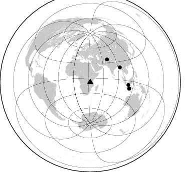
Azimuth Distribution of Events:
Prior Results for this Station
| Study | Thickness | Vp/Vs | Vp | Vs | Poissons Ratio | Extra |
| EARS | 38 km | 1.75 | 6.455 km/s | 3.684 km/s | 0.26 | |
| Crust2.0 | 42 km | 1.76 | 6.455 km/s | 3.663 km/s | 0.26 | GE,Archean, no seds. |
| Global Maxima | 38 km | 1.75 | 6.455 km/s | 3.684 km/s | 0.26 | amp=0.030455882 |
| Local Maxima 1 | 30 km | 1.96 | 6.455 km/s | 3.294 km/s | 0.32 | amp=0.022281516 |
| Local Maxima 2 | 33 km | 1.93 | 6.455 km/s | 3.349 km/s | 0.32 | amp=0.011813015 |
| Local Maxima 3 | 70 km | 1.75 | 6.455 km/s | 3.699 km/s | 0.26 | amp=0.01090873 |
| Local Maxima 4 | 47 km | 1.64 | 6.455 km/s | 3.942 km/s | 0.20 | amp=0.009729709 |
| Predicted Arrivals for vertical incidence (zero ray parameter) | |
| Ps | 4.43 SECOND |
| PpPs | 16.20 SECOND |
| PsPs/PpSs | 20.63 SECOND |
Events Processed for this Station
Download zip of receiver functions as SAC
Plot maxima for each earthquake.
Events Used in the Stack
(5 events)| Radial Match | Distance | Baz | FERegion | Time | Lat/Lon | Depth | Magnitude |
| 97.80344 | 78.9 deg | 99.438 deg | South Of Java, Indonesia | 1994/06/04 00:57:53 GMT | (-10.8, 113.4) | 33 km | 5.8 MB, 6.2 MS, 6.0 UNKNOWN |
| 93.82466 | 66.1 deg | 63.504 deg | Myanmar | 1994/05/29 14:11:51 GMT | (20.5, 94.2) | 42 km | 6.2 MB, 6.2 MS, 5.9 UNKNOWN, 6.5 MW |
| 89.50808 | 56.4 deg | 36.28 deg | Hindu Kush Region, Afghanistan | 1994/10/25 00:54:34 GMT | (36.3, 70.9) | 244 km | 5.9 MB, 6.2 UNKNOWN, 5.9 MW |
| 88.28479 | 76.4 deg | 94.036 deg | Java Sea | 1994/09/28 16:39:52 GMT | (-5.8, 110.3) | 643 km | 5.7 MB, 6.7 UNKNOWN, 6.6 MW |
| 87.717575 | 78.5 deg | 99.088 deg | South Of Java, Indonesia | 1994/06/02 18:17:36 GMT | (-10.5, 113.0) | 39 km | 5.5 MB, 7.2 MS, 6.8 UNKNOWN, 7.7 MW |
Losers
(12 events)| Radial Match | Distance | Baz | FERegion | Time | Lat/Lon | Depth | Magnitude | Reason |
| 79.81435 | 68.4 deg | 59.612 deg | Myanmar | 1994/08/08 21:08:31 GMT | (24.7, 95.2) | 127 km | 6.0 MB, 5.1 UNKNOWN, 6.1 MW | |
| 63.846096 | 70.1 deg | 51.357 deg | Xizang | 1994/06/29 18:22:36 GMT | (32.5, 93.7) | 33 km | 5.8 MB, 5.5 MS, 5.3 UNKNOWN, 5.7 MW | |
| 52.615078 | 98.2 deg | 235.996 deg | Near Coast Of Central Chile | 1994/10/11 01:37:20 GMT | (-32.1, -71.4) | 51 km | 5.6 MB, 5.3 MS, 5.8 UNKNOWN, 5.4 MD | |
| 48.76849 | 91.7 deg | 94.847 deg | Banda Sea | 1994/07/16 18:05:07 GMT | (-4.6, 125.6) | 461 km | 5.8 MB | |
| 38.273094 | 59.4 deg | 204.674 deg | Southwestern Atlantic Ocean | 1994/09/15 23:47:30 GMT | (-57.8, -8.7) | 10 km | 5.6 MS, 5.2 MB | |
| 36.479458 | 67.3 deg | 66.956 deg | Myanmar | 1994/08/19 21:02:45 GMT | (17.9, 96.4) | 12 km | 5.5 MB, 5.6 MS, 6.0 UNKNOWN, 5.8 MW | |
| 36.280964 | 93.4 deg | 84.472 deg | Mindanao, Philippines | 1994/07/06 09:13:11 GMT | (6.0, 125.9) | 164 km | 5.7 MB, 6.1 UNKNOWN | |
| 33.127926 | 79.4 deg | 98.989 deg | South Of Java, Indonesia | 1994/06/15 10:28:49 GMT | (-10.3, 113.8) | 29 km | 5.6 MB, 6.0 MS, 6.1 UNKNOWN | |
| 27.988632 | 93.7 deg | 97.928 deg | Banda Sea | 1994/06/16 10:12:48 GMT | (-7.4, 128.1) | 119 km | 5.8 MB, 6.0 UNKNOWN, 5.9 MW | |
| 26.273169 | 55.7 deg | 323.013 deg | Strait Of Gibraltar | 1994/05/26 08:26:52 GMT | (35.4, -4.1) | 10 km | 5.7 MB, 5.8 MS, 5.9 UNKNOWN | |
| 17.657557 | 79.0 deg | 99.082 deg | South Of Java, Indonesia | 1994/06/15 09:22:57 GMT | (-10.4, 113.5) | 33 km | 5.8 MB, 6.1 MS, 5.9 UNKNOWN, 6.0 MW | |
| 15.189601 | 93.5 deg | 98.02 deg | Banda Sea | 1994/07/13 11:45:25 GMT | (-7.5, 127.9) | 185 km | 6.4 MB, 6.8 UNKNOWN, 6.5 MW |
