
Station XD SING - XD.SING
Network: XD94 - Tanzania BB Experiment
Nearby stations (2 deg radius)
| Station | Name | (Lat, Lon) | Start / End | Elevation |
| SING | XD.SING | (-4.64, 34.73) | 1994-05-20 / 1995-05-28 | 1462 m |
| Crust2 Type: | X5,thick Rift 0.25 km sediments |
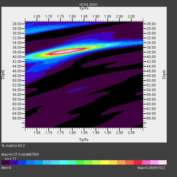
| Thickness Estimate: | 38 km |
| Thickness StdDev: | 0.2 km |
| Vp/Vs Estimate: | 1.77 |
| Vp/Vs StdDev: | 0.01 |
| Vs Estimate: | 3.729 km/s |
| Poisson's Ratio: | 0.27 |
| Peak Value: | 0.07 |
| Assumed Vp: | 6.601 km/s |
| Ps Weight: | 0.33333334 |
| PpPs Weight: | 0.33333334 |
| PsPs Weight: | 0.33333328 |
| Residual Complexity: | 0.348 |
| Nearby stations H: | +- |
| (2.0 deg) Vp/Vs: | +- |
19 with match > 90% ( 50.0 %) and 22 with match > 80% ( 57.894737 %) out of 38.
Download stack as xyz text file.
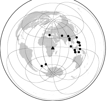
Azimuth Distribution of Events:
Prior Results for this Station
| Study | Thickness | Vp/Vs | Vp | Vs | Poissons Ratio | Extra |
| EARS | 38 km | 1.77 | 6.601 km/s | 3.729 km/s | 0.27 | |
| Crust2.0 | 38 km | 1.77 | 6.601 km/s | 3.729 km/s | 0.27 | X5,thick Rift 0.25 km sediments |
| Global Maxima | 38 km | 1.77 | 6.601 km/s | 3.729 km/s | 0.27 | amp=0.06891522 |
| Local Maxima 1 | 37 km | 1.73 | 6.601 km/s | 3.81 km/s | 0.25 | amp=0.019198794 |
| Local Maxima 2 | 38 km | 1.81 | 6.601 km/s | 3.647 km/s | 0.28 | amp=0.015543084 |
| Local Maxima 3 | 29 km | 1.64 | 6.601 km/s | 4.025 km/s | 0.20 | amp=0.015435623 |
| Local Maxima 4 | 28 km | 1.60 | 6.601 km/s | 4.125 km/s | 0.18 | amp=0.007777473 |
| Predicted Arrivals for vertical incidence (zero ray parameter) | |
| Ps | 4.37 SECOND |
| PpPs | 15.74 SECOND |
| PsPs/PpSs | 20.11 SECOND |
Events Processed for this Station
Download zip of receiver functions as SAC
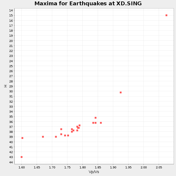
Plot maxima for each earthquake.
Events Used in the Stack
(22 events)| Radial Match | Distance | Baz | FERegion | Time | Lat/Lon | Depth | Magnitude |
| 98.376816 | 78.1 deg | 99.986 deg | South Of Java, Indonesia | 1994/06/04 00:57:53 GMT | (-10.8, 113.4) | 33 km | 5.8 MB, 6.2 MS, 6.0 UNKNOWN |
| 98.32242 | 77.5 deg | 99.674 deg | South Of Java, Indonesia | 1994/06/03 21:06:57 GMT | (-10.5, 112.9) | 16 km | 5.9 MB, 6.4 MS, 6.3 UNKNOWN, 6.6 MW |
| 97.295006 | 71.2 deg | 212.033 deg | South Sandwich Islands Region | 1995/03/26 02:16:16 GMT | (-55.9, -28.2) | 77 km | 6.1 MB, 5.9 MS, 6.4 UNKNOWN, 6.3 MW |
| 97.15499 | 91.9 deg | 78.189 deg | Samar, Philippines | 1995/04/21 00:09:56 GMT | (12.0, 125.7) | 33 km | 6.1 MB, 6.9 MS, 6.9 UNKNOWN, 6.8 MW |
| 97.08739 | 91.6 deg | 77.543 deg | Samar, Philippines | 1995/05/05 03:53:47 GMT | (12.6, 125.3) | 33 km | 6.2 MB, 7.0 MS, 7.1 UNKNOWN, 7.0 MW |
| 96.91614 | 89.7 deg | 98.342 deg | Timor Region | 1995/05/14 11:33:21 GMT | (-8.4, 125.1) | 33 km | 6.1 MB, 6.9 MS, 7.1 UNKNOWN, 6.9 MW |
| 96.579926 | 63.4 deg | 64.434 deg | Myanmar | 1994/05/29 14:11:51 GMT | (20.5, 94.2) | 42 km | 6.2 MB, 6.2 MS, 5.9 UNKNOWN, 6.5 MW |
| 96.46012 | 75.1 deg | 94.549 deg | Java Sea | 1994/11/15 20:18:11 GMT | (-5.6, 110.2) | 559 km | 6.2 MB, 6.5 UNKNOWN, 6.5 MW |
| 96.00314 | 92.1 deg | 78.066 deg | Samar, Philippines | 1995/04/21 05:17:00 GMT | (12.1, 125.9) | 23 km | 5.6 MB, 6.9 MS, 6.7 UNKNOWN, 6.7 MW |
| 95.791115 | 46.2 deg | 346.116 deg | Greece | 1995/05/13 08:47:12 GMT | (40.1, 21.7) | 13 km | 6.2 MB, 6.5 MS, 6.6 UNKNOWN, 6.5 MD |
| 95.7142 | 59.5 deg | 203.535 deg | Southern Mid-Atlantic Ridge | 1995/05/23 22:10:11 GMT | (-56.1, -3.2) | 10 km | 5.3 MB, 6.6 MS, 6.8 UNKNOWN, 6.7 MW |
| 95.65185 | 62.0 deg | 84.106 deg | Northern Sumatra, Indonesia | 1994/10/31 11:48:15 GMT | (3.0, 96.3) | 46 km | 5.6 MB, 6.1 MS, 6.3 UNKNOWN, 6.2 MW |
| 95.49707 | 65.8 deg | 60.085 deg | Myanmar-India Border Region | 1995/05/06 01:59:07 GMT | (25.0, 95.3) | 122 km | 6.4 MB, 6.5 UNKNOWN, 6.4 MW |
| 94.90782 | 87.5 deg | 76.294 deg | Mindoro, Philippines | 1994/11/14 19:15:30 GMT | (13.5, 121.1) | 33 km | 6.1 MB, 7.1 MS, 7.1 UNKNOWN, 7.1 MW |
| 93.5842 | 65.6 deg | 60.353 deg | Myanmar | 1994/08/08 21:08:31 GMT | (24.7, 95.2) | 127 km | 6.0 MB, 5.1 UNKNOWN, 6.1 MW |
| 93.04592 | 92.7 deg | 91.563 deg | Halmahera, Indonesia | 1995/02/13 15:04:26 GMT | (-1.4, 127.5) | 33 km | 6.2 MB, 6.8 MS, 6.8 UNKNOWN, 6.7 MW |
| 92.4062 | 75.2 deg | 94.728 deg | Java Sea | 1994/09/28 16:39:52 GMT | (-5.8, 110.3) | 643 km | 5.7 MB, 6.7 UNKNOWN, 6.6 MW |
| 90.91299 | 92.6 deg | 83.936 deg | Mindanao, Philippines | 1995/04/20 08:45:10 GMT | (6.3, 126.8) | 85 km | 6.2 MB, 6.6 UNKNOWN, 6.5 MW |
| 90.51337 | 53.1 deg | 36.513 deg | Hindu Kush Region, Afghanistan | 1995/05/16 03:35:03 GMT | (36.5, 70.9) | 190 km | 5.7 MB, 5.9 UNKNOWN, 5.8 MW |
| 85.28886 | 89.5 deg | 65.538 deg | Taiwan Region | 1994/06/05 01:09:31 GMT | (24.5, 122.0) | 16 km | 6.0 MB, 6.5 MS, 6.1 UNKNOWN, 6.4 MW |
| 82.42826 | 67.0 deg | 51.861 deg | Xizang | 1994/06/29 18:22:36 GMT | (32.5, 93.7) | 33 km | 5.8 MB, 5.5 MS, 5.3 UNKNOWN, 5.7 MW |
| 82.25389 | 91.6 deg | 77.79 deg | Samar, Philippines | 1995/04/23 05:08:03 GMT | (12.4, 125.4) | 33 km | 6.0 MB, 6.6 MS, 6.7 UNKNOWN, 6.7 MW |
Losers
(16 events)| Radial Match | Distance | Baz | FERegion | Time | Lat/Lon | Depth | Magnitude | Reason |
| 78.448494 | 92.6 deg | 97.686 deg | Banda Sea | 1994/07/13 11:45:25 GMT | (-7.5, 127.9) | 185 km | 6.4 MB, 6.8 UNKNOWN, 6.5 MW | |
| 77.92218 | 73.9 deg | 94.07 deg | Java Sea | 1995/05/13 21:00:54 GMT | (-5.2, 108.9) | 554 km | 5.7 MB, 5.9 UNKNOWN, 5.8 MW | |
| 77.69599 | 92.2 deg | 78.446 deg | Philippine Islands Region | 1995/04/29 09:44:00 GMT | (11.8, 126.0) | 33 km | 5.4 MB, 6.0 MS, 6.1 UNKNOWN, 6.0 MW | |
| 76.04159 | 93.9 deg | 88.459 deg | Halmahera, Indonesia | 1995/05/04 02:18:51 GMT | (1.9, 128.5) | 55 km | 6.0 MB, 6.0 MS, 6.1 UNKNOWN, 6.1 MW | |
| 74.915115 | 92.1 deg | 78.632 deg | Samar, Philippines | 1995/05/08 18:08:09 GMT | (11.6, 125.9) | 33 km | 5.6 MB, 6.2 MS, 6.3 UNKNOWN, 6.3 MW | |
| 71.40643 | 92.7 deg | 84.081 deg | Mindanao, Philippines | 1995/04/04 17:21:04 GMT | (6.2, 127.0) | 86 km | 5.5 MB | |
| 70.97442 | 41.1 deg | 347.547 deg | Crete, Greece | 1994/05/23 06:46:16 GMT | (35.6, 24.7) | 77 km | 6.0 MB, 6.1 UNKNOWN | |
| 70.2238 | 89.9 deg | 65.925 deg | Taiwan Region | 1994/05/23 05:36:03 GMT | (24.1, 122.5) | 34 km | 5.7 MB, 6.0 MS, 6.2 UNKNOWN, 6.1 MW | |
| 65.41447 | 62.9 deg | 204.48 deg | Southwestern Atlantic Ocean | 1994/09/15 23:47:30 GMT | (-57.8, -8.7) | 10 km | 5.6 MS, 5.2 MB | |
| 64.51734 | 91.9 deg | 84.963 deg | Mindanao, Philippines | 1995/02/19 00:17:48 GMT | (5.2, 126.2) | 104 km | 5.9 MB, 6.1 UNKNOWN, 6.1 MW | |
| 62.320606 | 89.6 deg | 83.972 deg | Mindanao, Philippines | 1995/04/23 06:38:11 GMT | (6.0, 123.8) | 531 km | 5.5 MB | |
| 59.4901 | 78.8 deg | 305.579 deg | Northern Mid-Atlantic Ridge | 1995/04/17 07:14:35 GMT | (33.8, -38.6) | 10 km | 5.8 MB, 5.8 MS, 5.9 UNKNOWN, 6.1 MW | |
| 57.781948 | 51.6 deg | 323.563 deg | Northern Algeria | 1994/08/18 01:13:06 GMT | (35.6, -0.1) | 9.0 km | 5.5 MB, 5.9 MS, 5.8 UNKNOWN | |
| 57.48482 | 91.8 deg | 211.863 deg | Drake Passage | 1995/01/03 16:11:59 GMT | (-57.7, -66.0) | 33 km | 6.1 MB, 5.6 MS, 6.1 UNKNOWN, 5.9 MW | |
| 49.393402 | 90.5 deg | 94.63 deg | Banda Sea | 1994/07/16 18:05:07 GMT | (-4.6, 125.6) | 461 km | 5.8 MB | |
| 48.598488 | 92.9 deg | 97.567 deg | Banda Sea | 1995/01/19 09:55:34 GMT | (-7.3, 128.3) | 170 km | 5.8 MB, 6.1 UNKNOWN, 5.9 MW |
