
Station XE SNPC4 - SNPC4
Network: XE05 - Sierra Nevada EarthScope Project- EarthScope Flex Array
Nearby stations (2 deg radius)
| Station | Name | (Lat, Lon) | Start / End | Elevation |
| SNPC4 | SNPC4 | (38.85, -120.95) | 2006-08-02 / 2007-09-19 | 516 m |
| Crust2 Type: | L3,continental arc, Southern Andes, 0.2 km seds. |
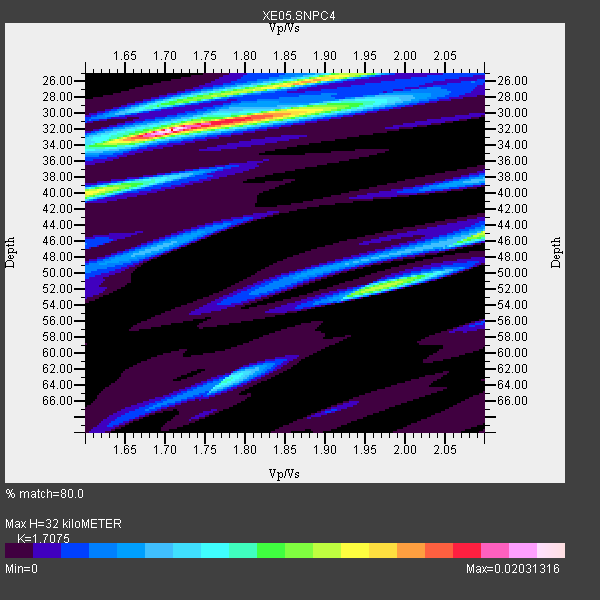
| Thickness Estimate: | 32 km |
| Thickness StdDev: | 11 km |
| Vp/Vs Estimate: | 1.71 |
| Vp/Vs StdDev: | 0.08 |
| Vs Estimate: | 3.864 km/s |
| Poisson's Ratio: | 0.24 |
| Peak Value: | 0.02 |
| Assumed Vp: | 6.597 km/s |
| Ps Weight: | 0.33333334 |
| PpPs Weight: | 0.33333334 |
| PsPs Weight: | 0.33333328 |
| Residual Complexity: | 0.639 |
| Nearby stations H: | +- |
| (2.0 deg) Vp/Vs: | +- |
2 with match > 90% ( 14.285714 %) and 3 with match > 80% ( 21.428572 %) out of 14.
Download stack as xyz text file.
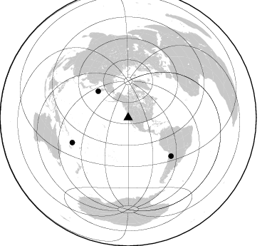
Azimuth Distribution of Events:
Prior Results for this Station
| Study | Thickness | Vp/Vs | Vp | Vs | Poissons Ratio | Extra |
| EARS | 32 km | 1.71 | 6.597 km/s | 3.864 km/s | 0.24 | |
| Crust2.0 | 40 km | 1.77 | 6.597 km/s | 3.723 km/s | 0.27 | L3,continental arc, Southern Andes, 0.2 km seds. |
| Global Maxima | 32 km | 1.71 | 6.597 km/s | 3.864 km/s | 0.24 | amp=0.02031316 |
| Local Maxima 1 | 26 km | 1.88 | 6.597 km/s | 3.519 km/s | 0.30 | amp=0.014107719 |
| Local Maxima 2 | 45 km | 2.10 | 6.597 km/s | 3.145 km/s | 0.35 | amp=0.012210643 |
| Local Maxima 3 | 40 km | 1.60 | 6.597 km/s | 4.123 km/s | 0.18 | amp=0.012046889 |
| Local Maxima 4 | 52 km | 1.98 | 6.597 km/s | 3.341 km/s | 0.33 | amp=0.009521415 |
| Predicted Arrivals for vertical incidence (zero ray parameter) | |
| Ps | 3.43 SECOND |
| PpPs | 13.13 SECOND |
| PsPs/PpSs | 16.56 SECOND |
Events Processed for this Station
Download zip of receiver functions as SAC
Plot maxima for each earthquake.
Events Used in the Stack
(3 events)| Radial Match | Distance | Baz | FERegion | Time | Lat/Lon | Depth | Magnitude |
| 92.79445 | 56.1 deg | 311.363 deg | Near East Coast Of Kamchatka | 2006/08/24 21:50:36 GMT | (51.1, 157.5) | 43 km | 5.9 MB, 6.2 MS, 6.5 MW, 6.5 MW |
| 92.45276 | 85.8 deg | 246.084 deg | Vanuatu Islands | 2006/08/07 22:18:54 GMT | (-15.8, 167.8) | 141 km | 6.0 MB, 6.8 MW, 6.8 MW |
| 87.10383 | 80.6 deg | 131.688 deg | Chile-Argentina Border Region | 2006/08/25 00:44:46 GMT | (-24.4, -67.0) | 184 km | 5.9 MB, 6.6 MW, 6.6 MW |
Losers
(11 events)| Radial Match | Distance | Baz | FERegion | Time | Lat/Lon | Depth | Magnitude | Reason |
| 76.66673 | 52.3 deg | 315.612 deg | Near East Coast Of Kamchatka | 2006/08/17 11:11:35 GMT | (55.6, 161.7) | 55 km | 6.1 MB, 5.7 MW, 5.7 MW | |
| 75.92738 | 57.3 deg | 310.214 deg | Kuril Islands | 2006/08/20 03:01:02 GMT | (49.8, 156.4) | 26 km | 5.8 MB, 5.7 MS, 6.0 MW, 5.9 MW | |
| 72.73724 | 30.6 deg | 130.751 deg | Oaxaca, Mexico | 2006/08/19 05:41:28 GMT | (16.2, -97.3) | 32 km | 5.1 MB, 5.1 MS, 5.6 MW, 5.6 MW | |
| 69.23533 | 67.4 deg | 312.088 deg | Sakhalin, Russia | 2006/08/17 15:20:35 GMT | (46.5, 141.9) | 17 km | 6.0 MB, 5.2 MS, 5.6 MW, 5.5 MW | |
| 64.731224 | 94.6 deg | 261.902 deg | Eastern New Guinea Reg., P.N.G. | 2006/08/15 05:43:20 GMT | (-9.3, 150.5) | 10 km | 5.9 MB, 5.3 MS, 5.7 MW, 5.7 MW | |
| 60.117905 | 42.1 deg | 307.026 deg | Andreanof Islands, Aleutian Is. | 2006/08/26 23:40:39 GMT | (51.3, -179.6) | 35 km | 5.8 MB, 5.6 MS, 5.7 MW, 5.6 MW | |
| 56.18458 | 77.8 deg | 293.601 deg | Bonin Islands, Japan Region | 2006/08/06 18:16:40 GMT | (26.1, 144.0) | 23 km | 6.0 MB, 5.6 MS, 5.8 MW, 5.8 MW | |
| 52.245712 | 86.5 deg | 138.344 deg | Mendoza Province, Argentina | 2006/08/05 14:03:43 GMT | (-33.1, -68.7) | 22 km | 5.7 MB, 5.2 MS, 5.6 MW, 5.5 MW | |
| 49.50366 | 70.8 deg | 127.954 deg | Central Peru | 2006/08/09 22:36:08 GMT | (-14.4, -70.7) | 29 km | 5.6 MB, 4.6 MS, 5.2 MW, 5.2 ML | |
| 47.05191 | 42.1 deg | 307.091 deg | Andreanof Islands, Aleutian Is. | 2006/08/26 23:46:18 GMT | (51.4, -179.5) | 35 km | 5.7 MB, 5.6 MS, 5.7 MW, 5.7 MW | |
| 37.465908 | 92.9 deg | 305.307 deg | Taiwan Region | 2006/08/27 17:11:17 GMT | (25.0, 122.9) | 146 km | 5.5 MB, 5.4 MW, 5.4 MW |
