
Station XE SNPG9 - SNPG9
Network: XE05 - Sierra Nevada EarthScope Project- EarthScope Flex Array
Nearby stations (2 deg radius)
| Station | Name | (Lat, Lon) | Start / End | Elevation |
| SNPG9 | SNPG9 | (40.35, -120.60) | 2006-08-10 / 2007-12-31 | 1332 m |
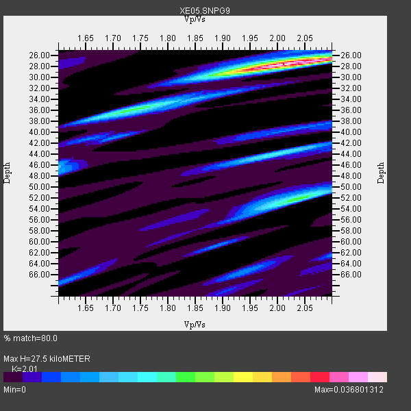
| Crust2 Type: | L8,thin continental arc, Cordilleras, 0.5 km seds. |
| Thickness Estimate: | 28 km |
| Thickness StdDev: | 7.6 km |
| Vp/Vs Estimate: | 2.01 |
| Vp/Vs StdDev: | 0.08 |
| Vs Estimate: | 3.267 km/s |
| Poisson's Ratio: | 0.34 |
| Peak Value: | 0.04 |
| Assumed Vp: | 6.566 km/s |
| Ps Weight: | 0.33333334 |
| PpPs Weight: | 0.33333334 |
| PsPs Weight: | 0.33333328 |
| Residual Complexity: | 0.518 |
| Nearby stations H: | +- |
| (2.0 deg) Vp/Vs: | +- |
4 with match > 90% ( 36.363636 %) and 5 with match > 80% ( 45.454544 %) out of 11.
Download stack as xyz text file.
Azimuth Distribution of Events:

Prior Results for this Station
| Study | Thickness | Vp/Vs | Vp | Vs | Poissons Ratio | Extra |
| EARS | 28 km | 2.01 | 6.566 km/s | 3.267 km/s | 0.34 | |
| Crust2.0 | 34 km | 1.77 | 6.566 km/s | 3.707 km/s | 0.27 | L8,thin continental arc, Cordilleras, 0.5 km seds. |
| Global Maxima | 28 km | 2.01 | 6.566 km/s | 3.267 km/s | 0.34 | amp=0.036801312 |
| Local Maxima 1 | 52 km | 2.04 | 6.566 km/s | 3.223 km/s | 0.34 | amp=0.017909642 |
| Local Maxima 2 | 36 km | 1.72 | 6.566 km/s | 3.829 km/s | 0.24 | amp=0.01539049 |
| Local Maxima 3 | 44 km | 1.99 | 6.566 km/s | 3.304 km/s | 0.33 | amp=0.013407288 |
| Local Maxima 4 | 66 km | 1.93 | 6.566 km/s | 3.393 km/s | 0.32 | amp=0.006888474 |
| Predicted Arrivals for vertical incidence (zero ray parameter) | |
| Ps | 4.23 SECOND |
| PpPs | 12.61 SECOND |
| PsPs/PpSs | 16.84 SECOND |
Events Processed for this Station
Download zip of receiver functions as SAC
Plot maxima for each earthquake.
Events Used in the Stack
(5 events)| Radial Match | Distance | Baz | FERegion | Time | Lat/Lon | Depth | Magnitude |
| 96.500244 | 55.3 deg | 310.695 deg | Near East Coast Of Kamchatka | 2006/08/24 21:50:36 GMT | (51.1, 157.5) | 43 km | 5.9 MB, 6.2 MS, 6.5 MW, 6.5 MW |
| 94.94743 | 80.2 deg | 231.44 deg | Fiji Islands Region | 2006/08/15 23:53:47 GMT | (-21.2, -176.3) | 158 km | 5.9 MB, 6.1 MW, 6.1 MW |
| 94.834785 | 66.6 deg | 311.76 deg | Sakhalin, Russia | 2006/08/17 15:20:35 GMT | (46.5, 141.9) | 17 km | 6.0 MB, 5.2 MS, 5.6 MW, 5.5 MW |
| 90.62162 | 56.5 deg | 309.574 deg | Kuril Islands | 2006/08/20 03:01:02 GMT | (49.8, 156.4) | 26 km | 5.8 MB, 5.7 MS, 6.0 MW, 5.9 MW |
| 88.866035 | 81.4 deg | 132.113 deg | Chile-Argentina Border Region | 2006/08/25 00:44:46 GMT | (-24.4, -67.0) | 184 km | 5.9 MB, 6.6 MW, 6.6 MW |
Losers
(6 events)| Radial Match | Distance | Baz | FERegion | Time | Lat/Lon | Depth | Magnitude | Reason |
| 84.71563 | 41.4 deg | 305.787 deg | Andreanof Islands, Aleutian Is. | 2006/08/26 23:46:18 GMT | (51.4, -179.5) | 35 km | 5.7 MB, 5.6 MS, 5.7 MW, 5.7 MW | |
| 78.06203 | 95.1 deg | 262.246 deg | Eastern New Guinea Reg., P.N.G. | 2006/08/15 05:43:20 GMT | (-9.3, 150.5) | 10 km | 5.9 MB, 5.3 MS, 5.7 MW, 5.7 MW | |
| 69.82094 | 31.4 deg | 133.119 deg | Oaxaca, Mexico | 2006/08/19 05:41:28 GMT | (16.2, -97.3) | 32 km | 5.1 MB, 5.1 MS, 5.6 MW, 5.6 MW | |
| 69.280136 | 92.2 deg | 305.589 deg | Taiwan Region | 2006/08/27 17:11:17 GMT | (25.0, 122.9) | 146 km | 5.5 MB, 5.4 MW, 5.4 MW | |
| 61.081738 | 85.0 deg | 303.791 deg | Ryukyu Islands, Japan | 2006/08/12 18:39:18 GMT | (28.8, 130.0) | 28 km | 5.6 MB, 5.0 MS, 5.5 MW, 5.4 MW | |
| 53.092136 | 85.2 deg | 251.709 deg | Santa Cruz Islands | 2006/08/28 14:24:07 GMT | (-10.8, 165.1) | 17 km | 5.4 MB, 5.4 MS, 5.7 MW |
