
Station XE YOS01 - YOS01
Network: XE05 - Sierra Nevada EarthScope Project- EarthScope Flex Array
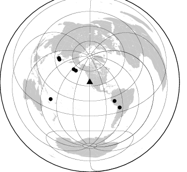
Nearby stations (2 deg radius)
| Station | Name | (Lat, Lon) | Start / End | Elevation |
| YOS01 | YOS01 | (37.75, -119.78) | 2007-07-02 / 2007-12-30 | 1866 m |
| Crust2 Type: | M9,thick extended crust, 0.5 km seds. |
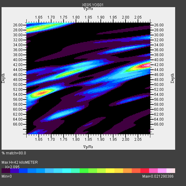
| Thickness Estimate: | 42 km |
| Thickness StdDev: | 8.4 km |
| Vp/Vs Estimate: | 2.10 |
| Vp/Vs StdDev: | 0.20 |
| Vs Estimate: | 3.003 km/s |
| Poisson's Ratio: | 0.35 |
| Peak Value: | 0.02 |
| Assumed Vp: | 6.291 km/s |
| Ps Weight: | 0.33333334 |
| PpPs Weight: | 0.33333334 |
| PsPs Weight: | 0.33333328 |
| Residual Complexity: | 0.797 |
| Nearby stations H: | +- |
| (2.0 deg) Vp/Vs: | +- |
6 with match > 90% ( 40.0 %) and 7 with match > 80% ( 46.666668 %) out of 15.
Download stack as xyz text file.
Azimuth Distribution of Events:
Prior Results for this Station
| Study | Thickness | Vp/Vs | Vp | Vs | Poissons Ratio | Extra |
| EARS | 42 km | 2.10 | 6.291 km/s | 3.003 km/s | 0.35 | |
| Crust2.0 | 40 km | 1.78 | 6.291 km/s | 3.539 km/s | 0.27 | M9,thick extended crust, 0.5 km seds. |
| Global Maxima | 42 km | 2.10 | 6.291 km/s | 3.003 km/s | 0.35 | amp=0.021290386 |
| Local Maxima 1 | 53 km | 1.67 | 6.291 km/s | 3.773 km/s | 0.22 | amp=0.015736701 |
| Local Maxima 2 | 28 km | 1.60 | 6.291 km/s | 3.926 km/s | 0.18 | amp=0.014105155 |
| Local Maxima 3 | 45 km | 1.78 | 6.291 km/s | 3.539 km/s | 0.27 | amp=0.009717574 |
| Local Maxima 4 | 26 km | 1.69 | 6.291 km/s | 3.717 km/s | 0.23 | amp=0.009093961 |
| Predicted Arrivals for vertical incidence (zero ray parameter) | |
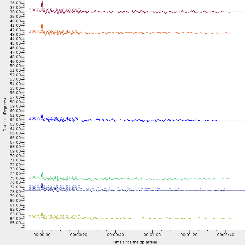
| Ps | 7.31 SECOND |
| PpPs | 20.66 SECOND |
| PsPs/PpSs | 27.97 SECOND |
Events Processed for this Station
Download zip of receiver functions as SAC
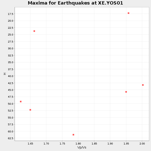
Plot maxima for each earthquake.
Events Used in the Stack
(7 events)| Radial Match | Distance | Baz | FERegion | Time | Lat/Lon | Depth | Magnitude |
| 96.49472 | 85.4 deg | 246.692 deg | Vanuatu Islands | 2007/07/15 09:27:34 GMT | (-15.4, 168.6) | 8.0 km | 6.0 MB, 5.8 MS, 6.1 MW, 6.0 MW |
| 95.0148 | 76.0 deg | 306.685 deg | Near West Coast Of Honshu, Japan | 2007/07/16 01:13:22 GMT | (37.5, 138.4) | 12 km | 6.5 MB, 6.4 MS, 6.6 MW, 6.5 MW |
| 93.67744 | 78.3 deg | 129.997 deg | Jujuy Province, Argentina | 2007/07/21 15:34:52 GMT | (-22.2, -65.8) | 290 km | 5.8 MB, 6.4 MW, 6.3 MW |
| 93.2572 | 36.4 deg | 309.698 deg | Fox Islands, Aleutian Islands | 2007/07/15 13:08:00 GMT | (52.5, -168.0) | 10 km | 5.8 MB, 5.9 MS, 6.1 MW, 6.0 MW |
| 93.13719 | 78.7 deg | 307.904 deg | Sea Of Japan | 2007/07/16 14:17:37 GMT | (36.8, 134.9) | 350 km | 6.2 MB, 6.8 MW, 6.8 MW |
| 92.498 | 41.4 deg | 308.589 deg | Andreanof Islands, Aleutian Is. | 2007/07/13 21:54:43 GMT | (51.8, -176.3) | 35 km | 5.7 MB, 5.6 MS, 6.0 MW, 5.9 MW |
| 88.90362 | 62.1 deg | 127.06 deg | Peru-Brazil Border Region | 2007/07/12 05:23:49 GMT | (-7.9, -74.4) | 152 km | 5.9 MB, 6.1 MW, 6.0 MW |
Losers
(8 events)| Radial Match | Distance | Baz | FERegion | Time | Lat/Lon | Depth | Magnitude | Reason |
| 77.725845 | 76.0 deg | 306.647 deg | Near West Coast Of Honshu, Japan | 2007/07/16 06:37:40 GMT | (37.5, 138.5) | 15 km | 5.7 MB, 5.1 MS, 5.7 MW, 5.6 MW | |
| 64.41029 | 89.2 deg | 89.735 deg | Central Mid-Atlantic Ridge | 2007/07/03 08:26:00 GMT | (0.7, -30.3) | 10 km | 5.8 MB, 5.9 MS, 6.3 MW, 6.1 MW | |
| 55.635487 | 64.3 deg | 124.582 deg | Western Brazil | 2007/07/21 13:27:04 GMT | (-8.1, -71.3) | 645 km | 6.2 MB, 6.1 MW, 6.0 MW | |
| 40.849174 | 34.6 deg | 124.566 deg | Guatemala | 2007/07/23 22:30:08 GMT | (14.4, -91.0) | 113 km | 5.5 MW, 5.3 MB, 5.5 MW | |
| 40.684654 | 89.0 deg | 242.729 deg | Loyalty Islands | 2007/07/20 17:23:53 GMT | (-20.8, 168.5) | 10 km | 5.5 MB, 4.9 MS, 5.6 MW, 5.5 MW | |
| 37.84271 | 93.0 deg | 266.699 deg | Bismarck Sea | 2007/07/23 00:08:32 GMT | (-4.5, 149.9) | 572 km | 5.9 MW, 5.1 MB, 5.9 MW | |
| 21.479883 | 52.7 deg | 112.848 deg | Northern Colombia | 2007/07/16 22:58:23 GMT | (7.2, -72.1) | 30 km | 5.5 MB, 4.5 MS, 5.1 MW, 5.6 ML | |
| 19.245293 | 73.3 deg | 233.029 deg | Samoa Islands Region | 2007/07/06 17:40:49 GMT | (-16.4, -172.6) | 10 km | 5.5 MB, 5.1 MS, 5.7 MW |
