
Station XE YOS02 - YOS02
Network: XE05 - Sierra Nevada EarthScope Project- EarthScope Flex Array
Nearby stations (2 deg radius)
| Station | Name | (Lat, Lon) | Start / End | Elevation |
| YOS02 | YOS02 | (37.77, -119.76) | 2007-07-02 / 2007-12-30 | 2116 m |
| Crust2 Type: | M9,thick extended crust, 0.5 km seds. |
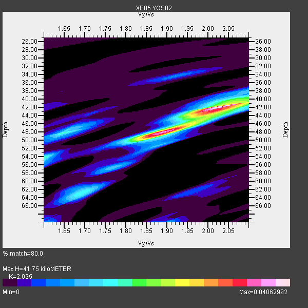
| Thickness Estimate: | 42 km |
| Thickness StdDev: | 3.1 km |
| Vp/Vs Estimate: | 2.04 |
| Vp/Vs StdDev: | 0.08 |
| Vs Estimate: | 3.092 km/s |
| Poisson's Ratio: | 0.34 |
| Peak Value: | 0.04 |
| Assumed Vp: | 6.291 km/s |
| Ps Weight: | 0.33333334 |
| PpPs Weight: | 0.33333334 |
| PsPs Weight: | 0.33333328 |
| Residual Complexity: | 0.591 |
| Nearby stations H: | +- |
| (2.0 deg) Vp/Vs: | +- |
4 with match > 90% ( 40.0 %) and 4 with match > 80% ( 40.0 %) out of 10.
Download stack as xyz text file.
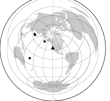
Azimuth Distribution of Events:
Prior Results for this Station
| Study | Thickness | Vp/Vs | Vp | Vs | Poissons Ratio | Extra |
| EARS | 42 km | 2.04 | 6.291 km/s | 3.092 km/s | 0.34 | |
| Crust2.0 | 40 km | 1.78 | 6.291 km/s | 3.539 km/s | 0.27 | M9,thick extended crust, 0.5 km seds. |
| Global Maxima | 42 km | 2.04 | 6.291 km/s | 3.092 km/s | 0.34 | amp=0.04062992 |
| Local Maxima 1 | 48 km | 1.88 | 6.291 km/s | 3.355 km/s | 0.30 | amp=0.031649202 |
| Local Maxima 2 | 44 km | 2.00 | 6.291 km/s | 3.154 km/s | 0.33 | amp=0.015617505 |
| Local Maxima 3 | 54 km | 1.60 | 6.291 km/s | 3.932 km/s | 0.18 | amp=0.015070013 |
| Local Maxima 4 | 63 km | 1.69 | 6.291 km/s | 3.717 km/s | 0.23 | amp=0.013727064 |
| Predicted Arrivals for vertical incidence (zero ray parameter) | |
| Ps | 6.87 SECOND |
| PpPs | 20.14 SECOND |
| PsPs/PpSs | 27.01 SECOND |
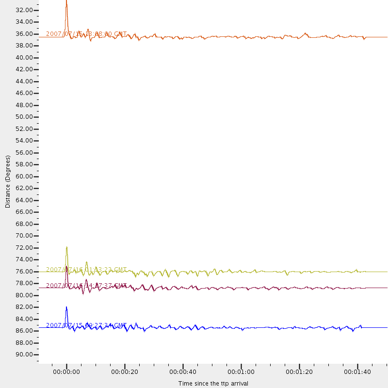
Events Processed for this Station
Download zip of receiver functions as SAC
Plot maxima for each earthquake.
Events Used in the Stack
(4 events)| Radial Match | Distance | Baz | FERegion | Time | Lat/Lon | Depth | Magnitude |
| 96.94001 | 36.4 deg | 309.673 deg | Fox Islands, Aleutian Islands | 2007/07/15 13:08:00 GMT | (52.5, -168.0) | 10 km | 5.8 MB, 5.9 MS, 6.1 MW, 6.0 MW |
| 96.73692 | 76.0 deg | 306.693 deg | Near West Coast Of Honshu, Japan | 2007/07/16 01:13:22 GMT | (37.5, 138.4) | 12 km | 6.5 MB, 6.4 MS, 6.6 MW, 6.5 MW |
| 95.9574 | 78.8 deg | 307.913 deg | Sea Of Japan | 2007/07/16 14:17:37 GMT | (36.8, 134.9) | 350 km | 6.2 MB, 6.8 MW, 6.8 MW |
| 95.79287 | 85.4 deg | 246.706 deg | Vanuatu Islands | 2007/07/15 09:27:34 GMT | (-15.4, 168.6) | 8.0 km | 6.0 MB, 5.8 MS, 6.1 MW, 6.0 MW |
Losers
(6 events)| Radial Match | Distance | Baz | FERegion | Time | Lat/Lon | Depth | Magnitude | Reason |
| 59.30109 | 62.1 deg | 127.091 deg | Peru-Brazil Border Region | 2007/07/12 05:23:49 GMT | (-7.9, -74.4) | 152 km | 5.9 MB, 6.1 MW, 6.0 MW | |
| 52.19042 | 83.8 deg | 229.964 deg | South Of Fiji Islands | 2007/07/18 00:07:35 GMT | (-26.3, -177.7) | 10 km | 5.8 MB, 5.9 MS, 6.1 MW, 6.0 MW | |
| 48.1426 | 96.0 deg | 305.968 deg | Taiwan | 2007/07/23 13:40:02 GMT | (23.7, 121.6) | 41 km | 5.6 MB, 4.9 MS | |
| 47.00972 | 52.7 deg | 112.885 deg | Northern Colombia | 2007/07/16 22:58:23 GMT | (7.2, -72.1) | 30 km | 5.5 MB, 4.5 MS, 5.1 MW, 5.6 ML | |
| 41.90603 | 93.0 deg | 266.715 deg | Bismarck Sea | 2007/07/23 00:08:32 GMT | (-4.5, 149.9) | 572 km | 5.9 MW, 5.1 MB, 5.9 MW | |
| 24.207977 | 76.0 deg | 306.655 deg | Near West Coast Of Honshu, Japan | 2007/07/16 06:37:40 GMT | (37.5, 138.5) | 15 km | 5.7 MB, 5.1 MS, 5.7 MW, 5.6 MW |
