
Station XE YOS05 - YOS05
Network: XE05 - Sierra Nevada EarthScope Project- EarthScope Flex Array
Nearby stations (2 deg radius)
| Station | Name | (Lat, Lon) | Start / End | Elevation |
| YOS05 | YOS05 | (37.84, -119.69) | 2007-07-02 / 2007-12-30 | 2385 m |
| Crust2 Type: | M9,thick extended crust, 0.5 km seds. |
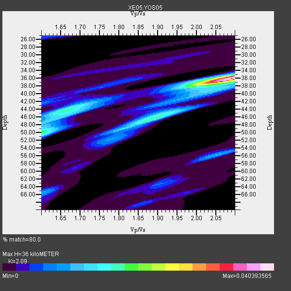
| Thickness Estimate: | 36 km |
| Thickness StdDev: | 6.6 km |
| Vp/Vs Estimate: | 2.09 |
| Vp/Vs StdDev: | 0.18 |
| Vs Estimate: | 3.01 km/s |
| Poisson's Ratio: | 0.35 |
| Peak Value: | 0.04 |
| Assumed Vp: | 6.291 km/s |
| Ps Weight: | 0.33333334 |
| PpPs Weight: | 0.33333334 |
| PsPs Weight: | 0.33333328 |
| Residual Complexity: | 0.614 |
| Nearby stations H: | +- |
| (2.0 deg) Vp/Vs: | +- |
4 with match > 90% ( 28.571428 %) and 6 with match > 80% ( 42.857143 %) out of 14.
Download stack as xyz text file.
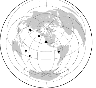
Azimuth Distribution of Events:
Prior Results for this Station
| Study | Thickness | Vp/Vs | Vp | Vs | Poissons Ratio | Extra |
| EARS | 36 km | 2.09 | 6.291 km/s | 3.01 km/s | 0.35 | |
| Crust2.0 | 40 km | 1.78 | 6.291 km/s | 3.539 km/s | 0.27 | M9,thick extended crust, 0.5 km seds. |
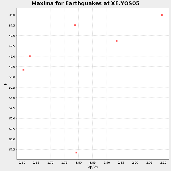
| Global Maxima | 36 km | 2.09 | 6.291 km/s | 3.01 km/s | 0.35 | amp=0.040393565 |
| Local Maxima 1 | 50 km | 1.60 | 6.291 km/s | 3.932 km/s | 0.18 | amp=0.01878409 |
| Local Maxima 2 | 47 km | 1.88 | 6.291 km/s | 3.351 km/s | 0.30 | amp=0.015419064 |
| Local Maxima 3 | 44 km | 1.66 | 6.291 km/s | 3.79 km/s | 0.22 | amp=0.015027817 |
| Local Maxima 4 | 56 km | 2.06 | 6.291 km/s | 3.054 km/s | 0.35 | amp=0.010172435 |
| Predicted Arrivals for vertical incidence (zero ray parameter) | |
| Ps | 6.24 SECOND |
| PpPs | 17.68 SECOND |
| PsPs/PpSs | 23.92 SECOND |
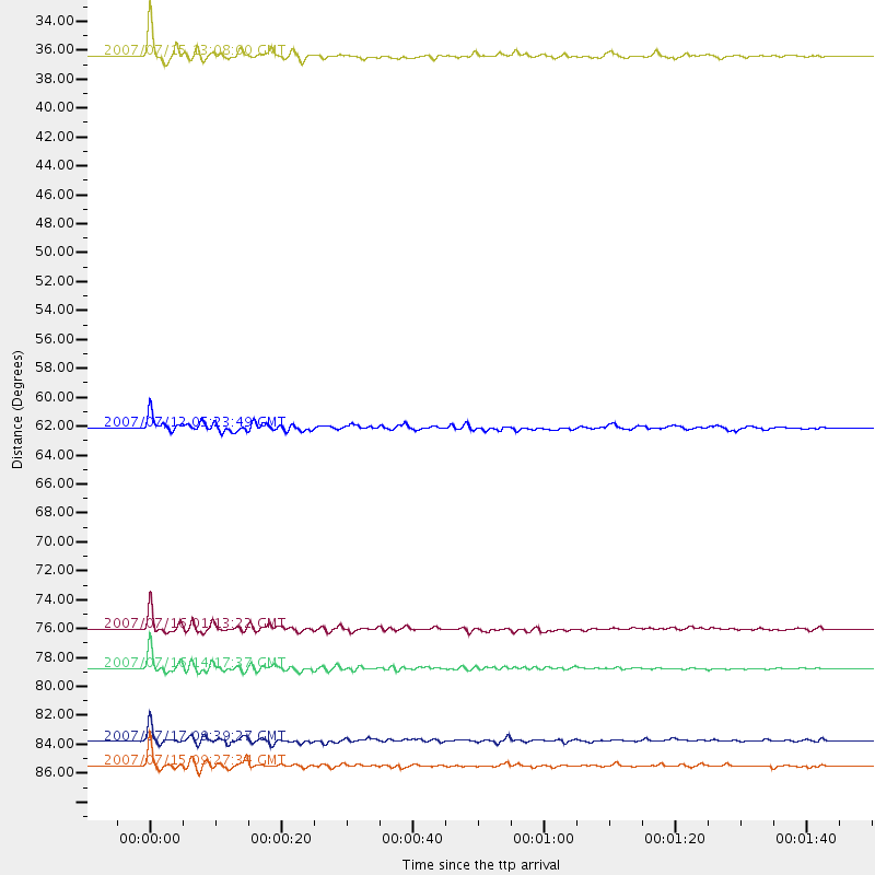
Events Processed for this Station
Download zip of receiver functions as SAC
Plot maxima for each earthquake.
Events Used in the Stack
(6 events)| Radial Match | Distance | Baz | FERegion | Time | Lat/Lon | Depth | Magnitude |
| 96.9268 | 36.4 deg | 309.599 deg | Fox Islands, Aleutian Islands | 2007/07/15 13:08:00 GMT | (52.5, -168.0) | 10 km | 5.8 MB, 5.9 MS, 6.1 MW, 6.0 MW |
| 96.729294 | 76.0 deg | 306.713 deg | Near West Coast Of Honshu, Japan | 2007/07/16 01:13:22 GMT | (37.5, 138.4) | 12 km | 6.5 MB, 6.4 MS, 6.6 MW, 6.5 MW |
| 96.530716 | 85.5 deg | 246.745 deg | Vanuatu Islands | 2007/07/15 09:27:34 GMT | (-15.4, 168.6) | 8.0 km | 6.0 MB, 5.8 MS, 6.1 MW, 6.0 MW |
| 95.448944 | 78.8 deg | 307.938 deg | Sea Of Japan | 2007/07/16 14:17:37 GMT | (36.8, 134.9) | 350 km | 6.2 MB, 6.8 MW, 6.8 MW |
| 84.03885 | 62.1 deg | 127.178 deg | Peru-Brazil Border Region | 2007/07/12 05:23:49 GMT | (-7.9, -74.4) | 152 km | 5.9 MB, 6.1 MW, 6.0 MW |
| 82.55978 | 83.8 deg | 230.068 deg | South Of Fiji Islands | 2007/07/17 09:39:27 GMT | (-26.2, -177.7) | 10 km | 5.7 MB, 6.0 MS, 6.1 MW, 6.0 MW |
Losers
(8 events)| Radial Match | Distance | Baz | FERegion | Time | Lat/Lon | Depth | Magnitude | Reason |
| 73.05869 | 78.3 deg | 130.078 deg | Jujuy Province, Argentina | 2007/07/21 15:34:52 GMT | (-22.2, -65.8) | 290 km | 5.8 MB, 6.4 MW, 6.3 MW | |
| 73.01861 | 76.0 deg | 306.676 deg | Near West Coast Of Honshu, Japan | 2007/07/16 06:37:40 GMT | (37.5, 138.5) | 15 km | 5.7 MB, 5.1 MS, 5.7 MW, 5.6 MW | |
| 60.930042 | 41.4 deg | 308.516 deg | Andreanof Islands, Aleutian Is. | 2007/07/13 21:54:43 GMT | (51.8, -176.3) | 35 km | 5.7 MB, 5.6 MS, 6.0 MW, 5.9 MW | |
| 59.249203 | 93.4 deg | 185.006 deg | Pacific-Antarctic Ridge | 2007/07/13 16:33:35 GMT | (-55.6, -128.5) | 10 km | 5.7 MW, 5.2 MS, 5.1 MB, 5.7 MW | |
| 44.628128 | 52.7 deg | 112.989 deg | Northern Colombia | 2007/07/16 22:58:23 GMT | (7.2, -72.1) | 30 km | 5.5 MB, 4.5 MS, 5.1 MW, 5.6 ML | |
| 44.586205 | 96.0 deg | 306.019 deg | Taiwan | 2007/07/23 13:40:02 GMT | (23.7, 121.6) | 41 km | 5.6 MB, 4.9 MS | |
| 38.096752 | 64.3 deg | 124.694 deg | Western Brazil | 2007/07/21 13:27:04 GMT | (-8.1, -71.3) | 645 km | 6.2 MB, 6.1 MW, 6.0 MW | |
| 19.958452 | 97.2 deg | 343.848 deg | Northern Xinjiang, China | 2007/07/20 10:06:52 GMT | (42.9, 82.4) | 10 km | 5.5 MB, 5.3 MS, 5.6 MW, 5.5 MW |
