
Station XE YOS06 - YOS06
Network: XE05 - Sierra Nevada EarthScope Project- EarthScope Flex Array
Nearby stations (2 deg radius)
| Station | Name | (Lat, Lon) | Start / End | Elevation |
| YOS06 | YOS06 | (37.85, -119.61) | 2007-07-02 / 2007-12-30 | 2507 m |
| Crust2 Type: | M9,thick extended crust, 0.5 km seds. |
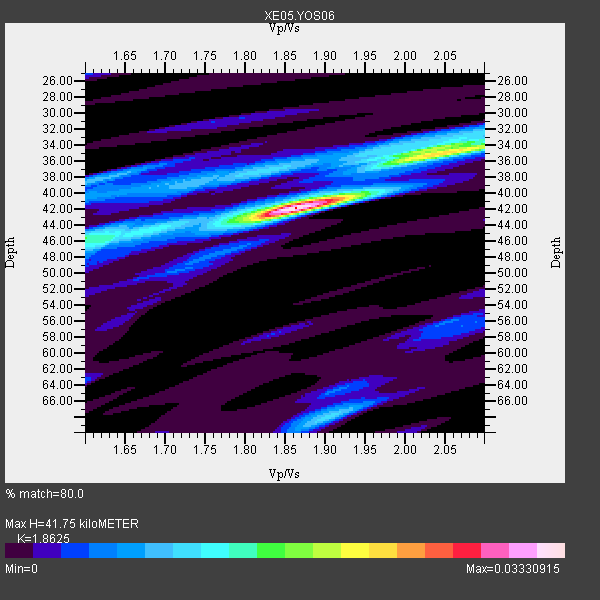
| Thickness Estimate: | 42 km |
| Thickness StdDev: | 4.8 km |
| Vp/Vs Estimate: | 1.86 |
| Vp/Vs StdDev: | 0.12 |
| Vs Estimate: | 3.378 km/s |
| Poisson's Ratio: | 0.30 |
| Peak Value: | 0.03 |
| Assumed Vp: | 6.291 km/s |
| Ps Weight: | 0.33333334 |
| PpPs Weight: | 0.33333334 |
| PsPs Weight: | 0.33333328 |
| Residual Complexity: | 0.558 |
| Nearby stations H: | +- |
| (2.0 deg) Vp/Vs: | +- |
4 with match > 90% ( 30.76923 %) and 6 with match > 80% ( 46.153847 %) out of 13.
Download stack as xyz text file.
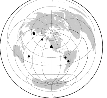
Azimuth Distribution of Events:
Prior Results for this Station
| Study | Thickness | Vp/Vs | Vp | Vs | Poissons Ratio | Extra |
| EARS | 42 km | 1.86 | 6.291 km/s | 3.378 km/s | 0.30 | |
| Crust2.0 | 40 km | 1.78 | 6.291 km/s | 3.539 km/s | 0.27 | M9,thick extended crust, 0.5 km seds. |
| Global Maxima | 42 km | 1.86 | 6.291 km/s | 3.378 km/s | 0.30 | amp=0.03330915 |
| Local Maxima 1 | 35 km | 2.06 | 6.291 km/s | 3.058 km/s | 0.35 | amp=0.018862478 |
| Local Maxima 2 | 68 km | 1.90 | 6.291 km/s | 3.302 km/s | 0.31 | amp=0.010769837 |
| Local Maxima 3 | 38 km | 1.61 | 6.291 km/s | 3.92 km/s | 0.18 | amp=0.009763042 |
| Local Maxima 4 | 46 km | 1.62 | 6.291 km/s | 3.889 km/s | 0.19 | amp=0.009212619 |
| Predicted Arrivals for vertical incidence (zero ray parameter) | |
| Ps | 5.72 SECOND |
| PpPs | 19.00 SECOND |
| PsPs/PpSs | 24.72 SECOND |
Events Processed for this Station
Download zip of receiver functions as SAC
Plot maxima for each earthquake.
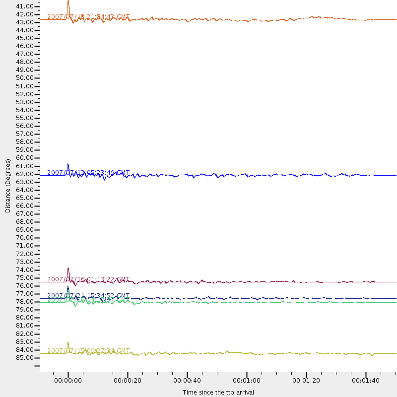
Events Used in the Stack
(6 events)| Radial Match | Distance | Baz | FERegion | Time | Lat/Lon | Depth | Magnitude |
| 96.53587 | 76.1 deg | 306.748 deg | Near West Coast Of Honshu, Japan | 2007/07/16 01:13:22 GMT | (37.5, 138.4) | 12 km | 6.5 MB, 6.4 MS, 6.6 MW, 6.5 MW |
| 95.337074 | 78.8 deg | 307.975 deg | Sea Of Japan | 2007/07/16 14:17:37 GMT | (36.8, 134.9) | 350 km | 6.2 MB, 6.8 MW, 6.8 MW |
| 93.63759 | 78.2 deg | 130.134 deg | Jujuy Province, Argentina | 2007/07/21 15:34:52 GMT | (-22.2, -65.8) | 290 km | 5.8 MB, 6.4 MW, 6.3 MW |
| 91.4436 | 85.6 deg | 246.791 deg | Vanuatu Islands | 2007/07/15 09:27:34 GMT | (-15.4, 168.6) | 8.0 km | 6.0 MB, 5.8 MS, 6.1 MW, 6.0 MW |
| 83.5005 | 62.1 deg | 127.248 deg | Peru-Brazil Border Region | 2007/07/12 05:23:49 GMT | (-7.9, -74.4) | 152 km | 5.9 MB, 6.1 MW, 6.0 MW |
| 82.78745 | 41.5 deg | 308.51 deg | Andreanof Islands, Aleutian Is. | 2007/07/13 21:54:43 GMT | (51.8, -176.3) | 35 km | 5.7 MB, 5.6 MS, 6.0 MW, 5.9 MW |
Losers
(7 events)| Radial Match | Distance | Baz | FERegion | Time | Lat/Lon | Depth | Magnitude | Reason |
| 70.72286 | 76.1 deg | 306.71 deg | Near West Coast Of Honshu, Japan | 2007/07/16 06:37:40 GMT | (37.5, 138.5) | 15 km | 5.7 MB, 5.1 MS, 5.7 MW, 5.6 MW | |
| 68.70151 | 64.2 deg | 124.761 deg | Western Brazil | 2007/07/21 13:27:04 GMT | (-8.1, -71.3) | 645 km | 6.2 MB, 6.1 MW, 6.0 MW | |
| 57.76173 | 34.5 deg | 124.898 deg | Guatemala | 2007/07/23 22:30:08 GMT | (14.4, -91.0) | 113 km | 5.5 MW, 5.3 MB, 5.5 MW | |
| 57.27878 | 89.2 deg | 242.832 deg | Loyalty Islands | 2007/07/20 17:23:53 GMT | (-20.8, 168.5) | 10 km | 5.5 MB, 4.9 MS, 5.6 MW, 5.5 MW | |
| 51.235962 | 73.4 deg | 233.132 deg | Samoa Islands Region | 2007/07/06 17:40:49 GMT | (-16.4, -172.6) | 10 km | 5.5 MB, 5.1 MS, 5.7 MW | |
| 48.014885 | 93.4 deg | 185.048 deg | Pacific-Antarctic Ridge | 2007/07/13 16:33:35 GMT | (-55.6, -128.5) | 10 km | 5.7 MW, 5.2 MS, 5.1 MB, 5.7 MW | |
| 40.82818 | 93.1 deg | 266.807 deg | Bismarck Sea | 2007/07/23 00:08:32 GMT | (-4.5, 149.9) | 572 km | 5.9 MW, 5.1 MB, 5.9 MW |
