
Station XE YOS08 - YOS08
Network: XE05 - Sierra Nevada EarthScope Project- EarthScope Flex Array
Nearby stations (2 deg radius)
| Station | Name | (Lat, Lon) | Start / End | Elevation |
| YOS08 | YOS08 | (37.81, -119.55) | 2007-07-02 / 2007-12-30 | 2493 m |
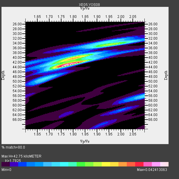
| Crust2 Type: | M9,thick extended crust, 0.5 km seds. |
| Thickness Estimate: | 43 km |
| Thickness StdDev: | 2.9 km |
| Vp/Vs Estimate: | 1.78 |
| Vp/Vs StdDev: | 0.06 |
| Vs Estimate: | 3.529 km/s |
| Poisson's Ratio: | 0.27 |
| Peak Value: | 0.04 |
| Assumed Vp: | 6.291 km/s |
| Ps Weight: | 0.33333334 |
| PpPs Weight: | 0.33333334 |
| PsPs Weight: | 0.33333328 |
| Residual Complexity: | 0.602 |
| Nearby stations H: | +- |
| (2.0 deg) Vp/Vs: | +- |
4 with match > 90% ( 33.333332 %) and 6 with match > 80% ( 50.0 %) out of 12.
Download stack as xyz text file.
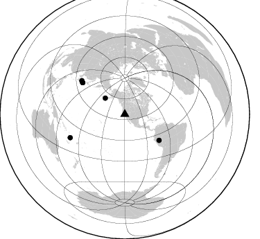
Azimuth Distribution of Events:
Prior Results for this Station
| Study | Thickness | Vp/Vs | Vp | Vs | Poissons Ratio | Extra |
| EARS | 43 km | 1.78 | 6.291 km/s | 3.529 km/s | 0.27 | |
| Crust2.0 | 40 km | 1.78 | 6.291 km/s | 3.539 km/s | 0.27 | M9,thick extended crust, 0.5 km seds. |
| Global Maxima | 43 km | 1.78 | 6.291 km/s | 3.529 km/s | 0.27 | amp=0.042413063 |
| Local Maxima 1 | 40 km | 1.80 | 6.291 km/s | 3.49 km/s | 0.28 | amp=0.023471424 |
| Local Maxima 2 | 34 km | 1.99 | 6.291 km/s | 3.165 km/s | 0.33 | amp=0.015289437 |
| Local Maxima 3 | 56 km | 2.10 | 6.291 km/s | 2.999 km/s | 0.35 | amp=0.014582533 |
| Local Maxima 4 | 34 km | 1.93 | 6.291 km/s | 3.264 km/s | 0.32 | amp=0.008822204 |
| Predicted Arrivals for vertical incidence (zero ray parameter) | |
| Ps | 5.32 SECOND |
| PpPs | 18.91 SECOND |
| PsPs/PpSs | 24.22 SECOND |
Events Processed for this Station
Download zip of receiver functions as SAC
Plot maxima for each earthquake.
Events Used in the Stack
(6 events)| Radial Match | Distance | Baz | FERegion | Time | Lat/Lon | Depth | Magnitude |
| 96.298416 | 85.6 deg | 246.839 deg | Vanuatu Islands | 2007/07/15 09:27:34 GMT | (-15.4, 168.6) | 8.0 km | 6.0 MB, 5.8 MS, 6.1 MW, 6.0 MW |
| 93.60776 | 78.9 deg | 308.017 deg | Sea Of Japan | 2007/07/16 14:17:37 GMT | (36.8, 134.9) | 350 km | 6.2 MB, 6.8 MW, 6.8 MW |
| 92.04876 | 76.2 deg | 306.791 deg | Near West Coast Of Honshu, Japan | 2007/07/16 01:13:22 GMT | (37.5, 138.4) | 12 km | 6.5 MB, 6.4 MS, 6.6 MW, 6.5 MW |
| 91.849655 | 36.5 deg | 309.622 deg | Fox Islands, Aleutian Islands | 2007/07/15 13:08:00 GMT | (52.5, -168.0) | 10 km | 5.8 MB, 5.9 MS, 6.1 MW, 6.0 MW |
| 83.997856 | 76.2 deg | 306.753 deg | Near West Coast Of Honshu, Japan | 2007/07/16 06:37:40 GMT | (37.5, 138.5) | 15 km | 5.7 MB, 5.1 MS, 5.7 MW, 5.6 MW |
| 81.40673 | 62.0 deg | 127.289 deg | Peru-Brazil Border Region | 2007/07/12 05:23:49 GMT | (-7.9, -74.4) | 152 km | 5.9 MB, 6.1 MW, 6.0 MW |
Losers
(6 events)| Radial Match | Distance | Baz | FERegion | Time | Lat/Lon | Depth | Magnitude | Reason |
| 61.600304 | 64.1 deg | 124.801 deg | Western Brazil | 2007/07/21 13:27:04 GMT | (-8.1, -71.3) | 645 km | 6.2 MB, 6.1 MW, 6.0 MW | |
| 61.126602 | 92.9 deg | 185.664 deg | Pacific-Antarctic Ridge | 2007/07/21 20:40:53 GMT | (-55.1, -129.4) | 10 km | 5.7 MW, 5.2 MS, 5.1 MB | |
| 57.478252 | 41.6 deg | 308.552 deg | Andreanof Islands, Aleutian Is. | 2007/07/13 21:54:43 GMT | (51.8, -176.3) | 35 km | 5.7 MB, 5.6 MS, 6.0 MW, 5.9 MW | |
| 56.549618 | 83.9 deg | 230.103 deg | South Of Fiji Islands | 2007/07/18 00:07:35 GMT | (-26.3, -177.7) | 10 km | 5.8 MB, 5.9 MS, 6.1 MW, 6.0 MW | |
| 42.40088 | 97.2 deg | 343.949 deg | Northern Xinjiang, China | 2007/07/20 10:06:52 GMT | (42.9, 82.4) | 10 km | 5.5 MB, 5.3 MS, 5.6 MW, 5.5 MW | |
| 25.590158 | 52.6 deg | 113.089 deg | Northern Colombia | 2007/07/16 22:58:23 GMT | (7.2, -72.1) | 30 km | 5.5 MB, 4.5 MS, 5.1 MW, 5.6 ML |
