
Station XE YOS09 - YOS09
Network: XE05 - Sierra Nevada EarthScope Project- EarthScope Flex Array
Nearby stations (2 deg radius)
| Station | Name | (Lat, Lon) | Start / End | Elevation |
| YOS09 | YOS09 | (37.82, -119.50) | 2007-07-02 / 2007-12-30 | 2575 m |
| Crust2 Type: | M9,thick extended crust, 0.5 km seds. |
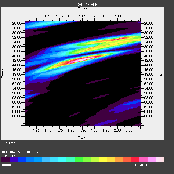
| Thickness Estimate: | 42 km |
| Thickness StdDev: | 3.6 km |
| Vp/Vs Estimate: | 1.85 |
| Vp/Vs StdDev: | 0.09 |
| Vs Estimate: | 3.401 km/s |
| Poisson's Ratio: | 0.29 |
| Peak Value: | 0.03 |
| Assumed Vp: | 6.291 km/s |
| Ps Weight: | 0.33333334 |
| PpPs Weight: | 0.33333334 |
| PsPs Weight: | 0.33333328 |
| Residual Complexity: | 0.729 |
| Nearby stations H: | +- |
| (2.0 deg) Vp/Vs: | +- |
4 with match > 90% ( 36.363636 %) and 5 with match > 80% ( 45.454544 %) out of 11.
Download stack as xyz text file.
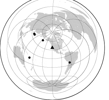
Azimuth Distribution of Events:
Prior Results for this Station
| Study | Thickness | Vp/Vs | Vp | Vs | Poissons Ratio | Extra |
| EARS | 42 km | 1.85 | 6.291 km/s | 3.401 km/s | 0.29 | |
| Crust2.0 | 40 km | 1.78 | 6.291 km/s | 3.539 km/s | 0.27 | M9,thick extended crust, 0.5 km seds. |
| Global Maxima | 42 km | 1.85 | 6.291 km/s | 3.401 km/s | 0.29 | amp=0.03373278 |
| Local Maxima 1 | 32 km | 2.00 | 6.291 km/s | 3.142 km/s | 0.33 | amp=0.030082116 |
| Local Maxima 2 | 33 km | 2.10 | 6.291 km/s | 2.999 km/s | 0.35 | amp=0.017416352 |
| Local Maxima 3 | 45 km | 1.71 | 6.291 km/s | 3.679 km/s | 0.24 | amp=0.017182024 |
| Local Maxima 4 | 26 km | 1.71 | 6.291 km/s | 3.679 km/s | 0.24 | amp=0.013788494 |
| Predicted Arrivals for vertical incidence (zero ray parameter) | |
| Ps | 5.61 SECOND |
| PpPs | 18.80 SECOND |
| PsPs/PpSs | 24.41 SECOND |
Events Processed for this Station
Download zip of receiver functions as SAC
Plot maxima for each earthquake.
Events Used in the Stack
(5 events)| Radial Match | Distance | Baz | FERegion | Time | Lat/Lon | Depth | Magnitude |
| 96.730034 | 76.2 deg | 306.811 deg | Near West Coast Of Honshu, Japan | 2007/07/16 01:13:22 GMT | (37.5, 138.4) | 12 km | 6.5 MB, 6.4 MS, 6.6 MW, 6.5 MW |
| 96.05055 | 85.6 deg | 246.866 deg | Vanuatu Islands | 2007/07/15 09:27:34 GMT | (-15.4, 168.6) | 8.0 km | 6.0 MB, 5.8 MS, 6.1 MW, 6.0 MW |
| 95.37572 | 78.9 deg | 308.039 deg | Sea Of Japan | 2007/07/16 14:17:37 GMT | (36.8, 134.9) | 350 km | 6.2 MB, 6.8 MW, 6.8 MW |
| 92.319115 | 78.1 deg | 130.21 deg | Jujuy Province, Argentina | 2007/07/21 15:34:52 GMT | (-22.2, -65.8) | 290 km | 5.8 MB, 6.4 MW, 6.3 MW |
| 87.89246 | 41.6 deg | 308.547 deg | Andreanof Islands, Aleutian Is. | 2007/07/13 21:54:43 GMT | (51.8, -176.3) | 35 km | 5.7 MB, 5.6 MS, 6.0 MW, 5.9 MW |
Losers
(6 events)| Radial Match | Distance | Baz | FERegion | Time | Lat/Lon | Depth | Magnitude | Reason |
| 73.94618 | 76.2 deg | 306.774 deg | Near West Coast Of Honshu, Japan | 2007/07/16 06:37:40 GMT | (37.5, 138.5) | 15 km | 5.7 MB, 5.1 MS, 5.7 MW, 5.6 MW | |
| 70.19246 | 62.0 deg | 127.331 deg | Peru-Brazil Border Region | 2007/07/12 05:23:49 GMT | (-7.9, -74.4) | 152 km | 5.9 MB, 6.1 MW, 6.0 MW | |
| 60.90986 | 64.1 deg | 124.841 deg | Western Brazil | 2007/07/21 13:27:04 GMT | (-8.1, -71.3) | 645 km | 6.2 MB, 6.1 MW, 6.0 MW | |
| 49.40958 | 34.4 deg | 125.0 deg | Guatemala | 2007/07/23 22:30:08 GMT | (14.4, -91.0) | 113 km | 5.5 MW, 5.3 MB, 5.5 MW | |
| 45.56804 | 89.2 deg | 242.903 deg | Loyalty Islands | 2007/07/20 17:23:53 GMT | (-20.8, 168.5) | 10 km | 5.5 MB, 4.9 MS, 5.6 MW, 5.5 MW | |
| 38.378113 | 52.6 deg | 113.132 deg | Northern Colombia | 2007/07/16 22:58:23 GMT | (7.2, -72.1) | 30 km | 5.5 MB, 4.5 MS, 5.1 MW, 5.6 ML |
