
Station XE YOS11 - YOS11
Network: XE05 - Sierra Nevada EarthScope Project- EarthScope Flex Array
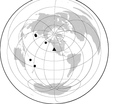
Nearby stations (2 deg radius)
| Station | Name | (Lat, Lon) | Start / End | Elevation |
| YOS11 | YOS11 | (37.88, -119.40) | 2007-07-02 / 2007-12-30 | 2624 m |
| Crust2 Type: | M9,thick extended crust, 0.5 km seds. |
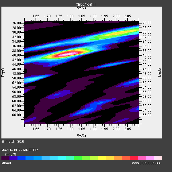
| Thickness Estimate: | 40 km |
| Thickness StdDev: | 1.4 km |
| Vp/Vs Estimate: | 1.78 |
| Vp/Vs StdDev: | 0.04 |
| Vs Estimate: | 3.534 km/s |
| Poisson's Ratio: | 0.27 |
| Peak Value: | 0.06 |
| Assumed Vp: | 6.291 km/s |
| Ps Weight: | 0.33333334 |
| PpPs Weight: | 0.33333334 |
| PsPs Weight: | 0.33333328 |
| Residual Complexity: | 0.618 |
| Nearby stations H: | +- |
| (2.0 deg) Vp/Vs: | +- |
4 with match > 90% ( 44.444443 %) and 5 with match > 80% ( 55.555557 %) out of 9.
Download stack as xyz text file.
Azimuth Distribution of Events:
Prior Results for this Station
| Study | Thickness | Vp/Vs | Vp | Vs | Poissons Ratio | Extra |
| EARS | 40 km | 1.78 | 6.291 km/s | 3.534 km/s | 0.27 | |
| Crust2.0 | 40 km | 1.78 | 6.291 km/s | 3.539 km/s | 0.27 | M9,thick extended crust, 0.5 km seds. |
| Global Maxima | 40 km | 1.78 | 6.291 km/s | 3.534 km/s | 0.27 | amp=0.058836944 |
| Local Maxima 1 | 30 km | 2.01 | 6.291 km/s | 3.13 km/s | 0.34 | amp=0.039141923 |
| Local Maxima 2 | 38 km | 1.78 | 6.291 km/s | 3.534 km/s | 0.27 | amp=0.021288272 |
| Local Maxima 3 | 50 km | 1.65 | 6.291 km/s | 3.813 km/s | 0.21 | amp=0.019686438 |
| Local Maxima 4 | 35 km | 1.71 | 6.291 km/s | 3.679 km/s | 0.24 | amp=0.017266594 |
| Predicted Arrivals for vertical incidence (zero ray parameter) | |
| Ps | 4.90 SECOND |
| PpPs | 17.45 SECOND |
| PsPs/PpSs | 22.35 SECOND |
Events Processed for this Station
Download zip of receiver functions as SAC
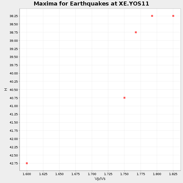
Plot maxima for each earthquake.
Events Used in the Stack
(5 events)| Radial Match | Distance | Baz | FERegion | Time | Lat/Lon | Depth | Magnitude |
| 95.70111 | 76.2 deg | 306.846 deg | Near West Coast Of Honshu, Japan | 2007/07/16 01:13:22 GMT | (37.5, 138.4) | 12 km | 6.5 MB, 6.4 MS, 6.6 MW, 6.5 MW |
| 95.07325 | 78.9 deg | 308.079 deg | Sea Of Japan | 2007/07/16 14:17:37 GMT | (36.8, 134.9) | 350 km | 6.2 MB, 6.8 MW, 6.8 MW |
| 94.45924 | 36.5 deg | 309.535 deg | Fox Islands, Aleutian Islands | 2007/07/15 13:08:00 GMT | (52.5, -168.0) | 10 km | 5.8 MB, 5.9 MS, 6.1 MW, 6.0 MW |
| 94.41853 | 85.7 deg | 246.924 deg | Vanuatu Islands | 2007/07/15 09:27:34 GMT | (-15.4, 168.6) | 8.0 km | 6.0 MB, 5.8 MS, 6.1 MW, 6.0 MW |
| 88.56569 | 84.0 deg | 230.255 deg | South Of Fiji Islands | 2007/07/17 09:39:27 GMT | (-26.2, -177.7) | 10 km | 5.7 MB, 6.0 MS, 6.1 MW, 6.0 MW |
Losers
(4 events)| Radial Match | Distance | Baz | FERegion | Time | Lat/Lon | Depth | Magnitude | Reason |
| 78.65815 | 62.0 deg | 127.443 deg | Peru-Brazil Border Region | 2007/07/12 05:23:49 GMT | (-7.9, -74.4) | 152 km | 5.9 MB, 6.1 MW, 6.0 MW | |
| 68.02673 | 76.2 deg | 306.809 deg | Near West Coast Of Honshu, Japan | 2007/07/16 06:37:40 GMT | (37.5, 138.5) | 15 km | 5.7 MB, 5.1 MS, 5.7 MW, 5.6 MW | |
| 64.29369 | 64.1 deg | 124.948 deg | Western Brazil | 2007/07/21 13:27:04 GMT | (-8.1, -71.3) | 645 km | 6.2 MB, 6.1 MW, 6.0 MW | |
| 36.127186 | 93.4 deg | 185.168 deg | Pacific-Antarctic Ridge | 2007/07/13 16:33:35 GMT | (-55.6, -128.5) | 10 km | 5.7 MW, 5.2 MS, 5.1 MB, 5.7 MW |
