
Station XE BATO - XE.BATO
Network: XE94 - BBand Andean Joint Exp. / Seismic Exploration of Deep Andes
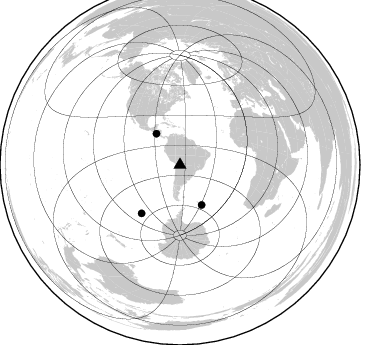
Nearby stations (2 deg radius)

| Station | Name | (Lat, Lon) | Start / End | Elevation |
| BATO | XE.BATO | (-19.63, -65.44) | 1994-12-03 / 1995-12-31 | 3353 m |
| Crust2 Type: | DC,Platform 0.5 km seds. |
| Thickness Estimate: | 50 km |
| Thickness StdDev: | 11 km |
| Vp/Vs Estimate: | 2.02 |
| Vp/Vs StdDev: | 0.15 |
| Vs Estimate: | 3.24 km/s |
| Poisson's Ratio: | 0.34 |
| Peak Value: | 0.03 |
| Assumed Vp: | 6.552 km/s |
| Ps Weight: | 0.33333334 |
| PpPs Weight: | 0.33333334 |
| PsPs Weight: | 0.33333328 |
| Residual Complexity: | 0.713 |
| Nearby stations H: | +- |
| (2.0 deg) Vp/Vs: | +- |
0 with match > 90% ( 0.0 %) and 3 with match > 80% ( 75.0 %) out of 4.
Download stack as xyz text file.
Azimuth Distribution of Events:
Prior Results for this Station
| Study | Thickness | Vp/Vs | Vp | Vs | Poissons Ratio | Extra |
| EARS | 50 km | 2.02 | 6.552 km/s | 3.24 km/s | 0.34 | |
| Crust2.0 | 41 km | 1.77 | 6.552 km/s | 3.698 km/s | 0.27 | DC,Platform 0.5 km seds. |
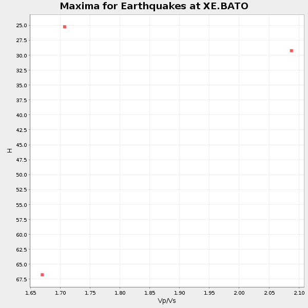
| Global Maxima | 50 km | 2.02 | 6.552 km/s | 3.24 km/s | 0.34 | amp=0.03272214 |
| Local Maxima 1 | 44 km | 2.01 | 6.552 km/s | 3.256 km/s | 0.34 | amp=0.020502076 |
| Local Maxima 2 | 64 km | 1.76 | 6.552 km/s | 3.728 km/s | 0.26 | amp=0.016024312 |
| Local Maxima 3 | 63 km | 1.69 | 6.552 km/s | 3.871 km/s | 0.23 | amp=0.014456154 |
| Local Maxima 4 | 30 km | 1.61 | 6.552 km/s | 4.07 km/s | 0.19 | amp=0.010378265 |
| Predicted Arrivals for vertical incidence (zero ray parameter) | |
| Ps | 7.84 SECOND |
| PpPs | 23.18 SECOND |
| PsPs/PpSs | 31.02 SECOND |
Events Processed for this Station
Download zip of receiver functions as SAC
Plot maxima for each earthquake.
Events Used in the Stack
(3 events)| Radial Match | Distance | Baz | FERegion | Time | Lat/Lon | Depth | Magnitude |
| 86.32247 | 45.7 deg | 151.51 deg | South Sandwich Islands Region | 1995/03/26 02:16:16 GMT | (-55.9, -28.2) | 77 km | 6.1 MB, 5.9 MS, 6.4 UNKNOWN, 6.3 MW |
| 84.58597 | 38.9 deg | 322.646 deg | Off Coast Of Central America | 1995/06/14 11:11:49 GMT | (12.2, -88.3) | 39 km | 5.6 MB, 6.0 MS, 6.6 UNKNOWN |
| 82.24022 | 62.0 deg | 218.625 deg | Pacific-Antarctic Ridge | 1995/05/09 12:29:57 GMT | (-54.0, -134.3) | 10 km | 5.4 MB, 5.7 MS, 5.9 UNKNOWN |
Losers
(1 events)| Radial Match | Distance | Baz | FERegion | Time | Lat/Lon | Depth | Magnitude | Reason |
| 83.93557 | 92.9 deg | 197.967 deg | Balleny Islands Region | 1995/06/21 15:28:51 GMT | (-61.6, 154.7) | 10 km | 5.6 MB, 6.7 MS, 6.8 UNKNOWN, 6.8 MW |
