
Station XE CRIS - XE.CRIS
Network: XE94 - BBand Andean Joint Exp. / Seismic Exploration of Deep Andes
Nearby stations (2 deg radius)
| Station | Name | (Lat, Lon) | Start / End | Elevation |
| CRIS | XE.CRIS | (-19.37, -65.93) | 1994-03-27 / 1995-12-31 | 3566 m |
| Crust2 Type: | DC,Platform 0.5 km seds. |
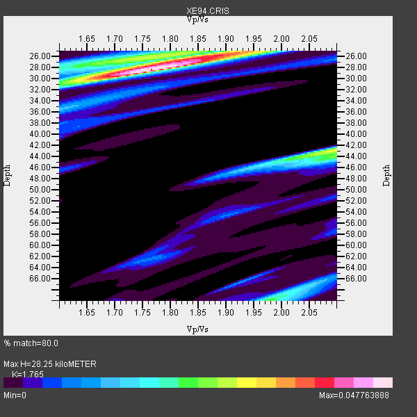
| Thickness Estimate: | 28 km |
| Thickness StdDev: | 9.8 km |
| Vp/Vs Estimate: | 1.76 |
| Vp/Vs StdDev: | 0.14 |
| Vs Estimate: | 3.712 km/s |
| Poisson's Ratio: | 0.26 |
| Peak Value: | 0.05 |
| Assumed Vp: | 6.552 km/s |
| Ps Weight: | 0.33333334 |
| PpPs Weight: | 0.33333334 |
| PsPs Weight: | 0.33333328 |
| Residual Complexity: | 0.609 |
| Nearby stations H: | +- |
| (2.0 deg) Vp/Vs: | +- |
2 with match > 90% ( 40.0 %) and 3 with match > 80% ( 60.0 %) out of 5.
Download stack as xyz text file.
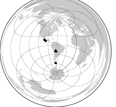
Azimuth Distribution of Events:
Prior Results for this Station
| Study | Thickness | Vp/Vs | Vp | Vs | Poissons Ratio | Extra |
| EARS | 28 km | 1.76 | 6.552 km/s | 3.712 km/s | 0.26 | |
| Crust2.0 | 41 km | 1.77 | 6.552 km/s | 3.698 km/s | 0.27 | DC,Platform 0.5 km seds. |
| Global Maxima | 28 km | 1.76 | 6.552 km/s | 3.712 km/s | 0.26 | amp=0.047763888 |
| Local Maxima 1 | 43 km | 2.10 | 6.552 km/s | 3.124 km/s | 0.35 | amp=0.029340679 |
| Local Maxima 2 | 26 km | 1.89 | 6.552 km/s | 3.458 km/s | 0.31 | amp=0.029286869 |
| Local Maxima 3 | 70 km | 1.98 | 6.552 km/s | 3.318 km/s | 0.33 | amp=0.021951007 |
| Local Maxima 4 | 26 km | 1.70 | 6.552 km/s | 3.849 km/s | 0.24 | amp=0.01633611 |
| Predicted Arrivals for vertical incidence (zero ray parameter) | |
| Ps | 3.30 SECOND |
| PpPs | 11.92 SECOND |
| PsPs/PpSs | 15.22 SECOND |
Events Processed for this Station
Download zip of receiver functions as SAC
Plot maxima for each earthquake.
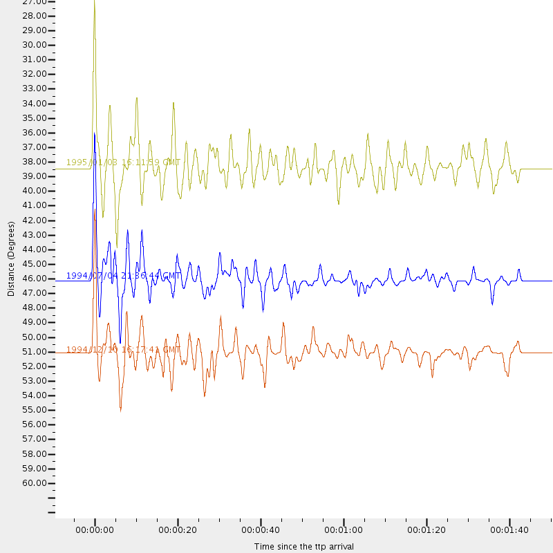
Events Used in the Stack
(3 events)| Radial Match | Distance | Baz | FERegion | Time | Lat/Lon | Depth | Magnitude |
| 91.881714 | 51.1 deg | 314.91 deg | Guerrero, Mexico | 1994/12/10 16:17:41 GMT | (18.2, -101.4) | 67 km | 6.5 MB, 6.6 UNKNOWN, 6.5 MW |
| 90.772095 | 46.0 deg | 315.585 deg | Off Coast Of Oaxaca, Mexico | 1994/07/04 21:36:44 GMT | (14.9, -97.3) | 33 km | 6.1 MB, 6.1 MS, 6.5 UNKNOWN, 6.5 MD |
| 81.16724 | 38.3 deg | 180.025 deg | Drake Passage | 1995/01/03 16:11:59 GMT | (-57.7, -66.0) | 33 km | 6.1 MB, 5.6 MS, 6.1 UNKNOWN, 5.9 MW |
Losers
(2 events)| Radial Match | Distance | Baz | FERegion | Time | Lat/Lon | Depth | Magnitude | Reason |
| 78.195526 | 56.0 deg | 214.652 deg | Southern East Pacific Rise | 1995/01/04 06:28:39 GMT | (-56.1, -123.2) | 10 km | 5.8 MS, 5.1 MB, 6.0 UNKNOWN | |
| 45.099773 | 97.9 deg | 235.909 deg | Kermadec Islands Region | 1994/06/20 09:44:46 GMT | (-28.8, -176.9) | 33 km | 5.8 MS, 5.2 MB, 5.9 UNKNOWN |
