
Station XE CRUZ - XE.CRUZ
Network: XE94 - BBand Andean Joint Exp. / Seismic Exploration of Deep Andes
Nearby stations (2 deg radius)
| Station | Name | (Lat, Lon) | Start / End | Elevation |
| CRUZ | XE.CRUZ | (-19.10, -66.22) | 1994-03-27 / 1995-12-31 | 4267 m |
| Crust2 Type: | RC,orogen/65km Tibet, 4.5 km seds. |
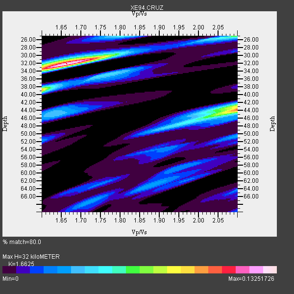
| Thickness Estimate: | 32 km |
| Thickness StdDev: | 7.0 km |
| Vp/Vs Estimate: | 1.66 |
| Vp/Vs StdDev: | 0.20 |
| Vs Estimate: | 3.801 km/s |
| Poisson's Ratio: | 0.22 |
| Peak Value: | 0.13 |
| Assumed Vp: | 6.319 km/s |
| Ps Weight: | 0.33333334 |
| PpPs Weight: | 0.33333334 |
| PsPs Weight: | 0.33333328 |
| Residual Complexity: | 0.723 |
| Nearby stations H: | +- |
| (2.0 deg) Vp/Vs: | +- |
0 with match > 90% ( 0.0 %) and 3 with match > 80% ( 50.0 %) out of 6.
Download stack as xyz text file.
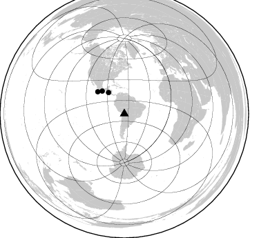
Azimuth Distribution of Events:
Prior Results for this Station
| Study | Thickness | Vp/Vs | Vp | Vs | Poissons Ratio | Extra |
| EARS | 32 km | 1.66 | 6.319 km/s | 3.801 km/s | 0.22 | |
| Crust2.0 | 65 km | 1.76 | 6.319 km/s | 3.593 km/s | 0.26 | RC,orogen/65km Tibet, 4.5 km seds. |
| Global Maxima | 32 km | 1.66 | 6.319 km/s | 3.801 km/s | 0.22 | amp=0.13251726 |
| Local Maxima 1 | 44 km | 2.10 | 6.319 km/s | 3.013 km/s | 0.35 | amp=0.102239214 |
| Local Maxima 2 | 39 km | 1.60 | 6.319 km/s | 3.95 km/s | 0.18 | amp=0.09105629 |
| Local Maxima 3 | 25 km | 2.08 | 6.319 km/s | 3.034 km/s | 0.35 | amp=0.056768622 |
| Local Maxima 4 | 43 km | 2.10 | 6.319 km/s | 3.013 km/s | 0.35 | amp=0.048989017 |
| Predicted Arrivals for vertical incidence (zero ray parameter) | |
| Ps | 3.35 SECOND |
| PpPs | 13.48 SECOND |
| PsPs/PpSs | 16.84 SECOND |
Events Processed for this Station
Download zip of receiver functions as SAC
Plot maxima for each earthquake.
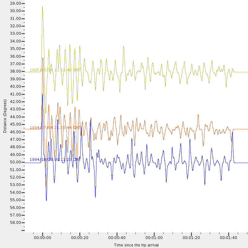
Events Used in the Stack
(3 events)| Radial Match | Distance | Baz | FERegion | Time | Lat/Lon | Depth | Magnitude |
| 89.590904 | 45.6 deg | 315.688 deg | Off Coast Of Oaxaca, Mexico | 1994/07/04 21:36:44 GMT | (14.9, -97.3) | 33 km | 6.1 MB, 6.1 MS, 6.5 UNKNOWN, 6.5 MD |
| 84.61478 | 38.0 deg | 323.254 deg | Off Coast Of Central America | 1995/06/14 11:11:49 GMT | (12.2, -88.3) | 39 km | 5.6 MB, 6.0 MS, 6.6 UNKNOWN |
| 81.91888 | 49.8 deg | 309.492 deg | Off Coast Of Guerrero, Mexico | 1994/10/28 09:11:20 GMT | (14.6, -103.7) | 33 km | 5.5 MS, 5.2 MB |
Losers
(3 events)| Radial Match | Distance | Baz | FERegion | Time | Lat/Lon | Depth | Magnitude | Reason |
| 79.45441 | 61.9 deg | 218.402 deg | Pacific-Antarctic Ridge | 1995/05/09 12:29:57 GMT | (-54.0, -134.3) | 10 km | 5.4 MB, 5.7 MS, 5.9 UNKNOWN | |
| 58.050583 | 82.9 deg | 48.701 deg | Northern Algeria | 1994/08/18 01:13:06 GMT | (35.6, -0.1) | 9.0 km | 5.5 MB, 5.9 MS, 5.8 UNKNOWN | |
| 48.68279 | 46.8 deg | 151.332 deg | South Sandwich Islands Region | 1995/05/20 13:45:02 GMT | (-56.0, -27.7) | 100 km | 5.5 MB, 5.5 UNKNOWN |
