
Station XE DOOR - XE.DOOR
Network: XE94 - BBand Andean Joint Exp. / Seismic Exploration of Deep Andes
Nearby stations (2 deg radius)
| Station | Name | (Lat, Lon) | Start / End | Elevation |
| DOOR | XE.DOOR | (-19.35, -67.22) | 1994-03-27 / 1995-12-31 | 3749 m |
| Crust2 Type: | RC,orogen/65km Tibet, 4.5 km seds. |
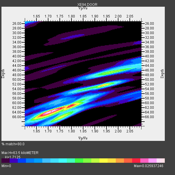
| Thickness Estimate: | 64 km |
| Thickness StdDev: | 11 km |
| Vp/Vs Estimate: | 1.71 |
| Vp/Vs StdDev: | 0.14 |
| Vs Estimate: | 3.69 km/s |
| Poisson's Ratio: | 0.24 |
| Peak Value: | 0.03 |
| Assumed Vp: | 6.319 km/s |
| Ps Weight: | 0.33333334 |
| PpPs Weight: | 0.33333334 |
| PsPs Weight: | 0.33333328 |
| Residual Complexity: | 0.711 |
| Nearby stations H: | +- |
| (2.0 deg) Vp/Vs: | +- |
2 with match > 90% ( 16.666666 %) and 5 with match > 80% ( 41.666668 %) out of 12.
Download stack as xyz text file.
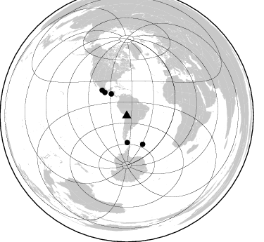
Azimuth Distribution of Events:
Prior Results for this Station
| Study | Thickness | Vp/Vs | Vp | Vs | Poissons Ratio | Extra |
| EARS | 64 km | 1.71 | 6.319 km/s | 3.69 km/s | 0.24 | |
| Crust2.0 | 65 km | 1.76 | 6.319 km/s | 3.593 km/s | 0.26 | RC,orogen/65km Tibet, 4.5 km seds. |
| Global Maxima | 64 km | 1.71 | 6.319 km/s | 3.69 km/s | 0.24 | amp=0.025937246 |
| Local Maxima 1 | 52 km | 1.93 | 6.319 km/s | 3.278 km/s | 0.32 | amp=0.01844563 |
| Local Maxima 2 | 47 km | 1.96 | 6.319 km/s | 3.224 km/s | 0.32 | amp=0.012883346 |
| Local Maxima 3 | 61 km | 1.80 | 6.319 km/s | 3.511 km/s | 0.28 | amp=0.012188639 |
| Local Maxima 4 | 66 km | 1.65 | 6.319 km/s | 3.83 km/s | 0.21 | amp=0.010317027 |
| Predicted Arrivals for vertical incidence (zero ray parameter) | |
| Ps | 7.16 SECOND |
| PpPs | 27.26 SECOND |
| PsPs/PpSs | 34.42 SECOND |
Events Processed for this Station
Download zip of receiver functions as SAC
Plot maxima for each earthquake.
Events Used in the Stack
(5 events)| Radial Match | Distance | Baz | FERegion | Time | Lat/Lon | Depth | Magnitude |
| 95.496895 | 38.3 deg | 178.905 deg | Drake Passage | 1995/01/03 16:11:59 GMT | (-57.7, -66.0) | 33 km | 6.1 MB, 5.6 MS, 6.1 UNKNOWN, 5.9 MW |
| 94.164085 | 46.7 deg | 150.812 deg | South Sandwich Islands Region | 1995/03/26 02:16:16 GMT | (-55.9, -28.2) | 77 km | 6.1 MB, 5.9 MS, 6.4 UNKNOWN, 6.3 MW |
| 88.00055 | 50.2 deg | 316.038 deg | Guerrero, Mexico | 1994/12/10 16:17:41 GMT | (18.2, -101.4) | 67 km | 6.5 MB, 6.6 UNKNOWN, 6.5 MW |
| 87.764366 | 45.2 deg | 316.86 deg | Off Coast Of Oaxaca, Mexico | 1994/07/04 21:36:44 GMT | (14.9, -97.3) | 33 km | 6.1 MB, 6.1 MS, 6.5 UNKNOWN, 6.5 MD |
| 87.35094 | 37.6 deg | 324.756 deg | Off Coast Of Central America | 1995/06/14 11:11:49 GMT | (12.2, -88.3) | 39 km | 5.6 MB, 6.0 MS, 6.6 UNKNOWN |
Losers
(7 events)| Radial Match | Distance | Baz | FERegion | Time | Lat/Lon | Depth | Magnitude | Reason |
| 86.42962 | 97.7 deg | 219.191 deg | South Island, New Zealand | 1994/06/19 13:43:51 GMT | (-43.1, 171.6) | 10 km | 5.7 MB, 5.9 MS, 5.9 UNKNOWN, 6.2 MW | |
| 75.552315 | 97.0 deg | 226.59 deg | Off E. Coast Of N. Island, N.Z. | 1994/12/15 11:20:22 GMT | (-37.3, 177.5) | 33 km | 5.7 MB, 6.4 MS, 6.5 UNKNOWN, 6.3 MW | |
| 74.377914 | 97.9 deg | 219.359 deg | South Island, New Zealand | 1994/06/18 03:25:19 GMT | (-42.9, 171.5) | 33 km | 6.2 MB, 7.1 MS, 7.1 UNKNOWN, 6.8 MW | |
| 73.04789 | 47.9 deg | 73.049 deg | Central Mid-Atlantic Ridge | 1995/05/18 00:06:26 GMT | (-0.9, -22.0) | 10 km | 6.2 MB, 6.1 MS, 6.8 UNKNOWN, 6.7 MW | |
| 70.08857 | 66.0 deg | 216.415 deg | Pacific-Antarctic Ridge | 1994/11/16 06:54:02 GMT | (-56.1, -142.6) | 10 km | 5.2 MB, 5.6 MS | |
| 66.69386 | 47.0 deg | 150.772 deg | South Sandwich Islands Region | 1995/05/20 13:45:02 GMT | (-56.0, -27.7) | 100 km | 5.5 MB, 5.5 UNKNOWN | |
| 65.98044 | 93.7 deg | 45.521 deg | Corsica, France | 1995/05/02 12:28:27 GMT | (43.2, 9.4) | 10 km | 5.9 UNKNOWN, 5.9 MW |
