
Station XE PACH - XE.PACH
Network: XE94 - BBand Andean Joint Exp. / Seismic Exploration of Deep Andes
Nearby stations (2 deg radius)
| Station | Name | (Lat, Lon) | Start / End | Elevation |
| PACH | XE.PACH | (-19.87, -69.42) | 1994-03-27 / 1995-12-31 | 1620 m |
| Crust2 Type: | RA,orogen/65km Tibet, 1.0 km seds. |
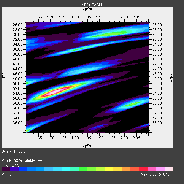
| Thickness Estimate: | 53 km |
| Thickness StdDev: | 6.0 km |
| Vp/Vs Estimate: | 1.72 |
| Vp/Vs StdDev: | 0.05 |
| Vs Estimate: | 3.763 km/s |
| Poisson's Ratio: | 0.24 |
| Peak Value: | 0.03 |
| Assumed Vp: | 6.454 km/s |
| Ps Weight: | 0.33333334 |
| PpPs Weight: | 0.33333334 |
| PsPs Weight: | 0.33333328 |
| Residual Complexity: | 0.712 |
| Nearby stations H: | +- |
| (2.0 deg) Vp/Vs: | +- |
0 with match > 90% ( 0.0 %) and 2 with match > 80% ( 33.333332 %) out of 6.
Download stack as xyz text file.
Azimuth Distribution of Events:

Prior Results for this Station
| Study | Thickness | Vp/Vs | Vp | Vs | Poissons Ratio | Extra |
| EARS | 53 km | 1.72 | 6.454 km/s | 3.763 km/s | 0.24 | |
| Crust2.0 | 65 km | 1.76 | 6.454 km/s | 3.668 km/s | 0.26 | RA,orogen/65km Tibet, 1.0 km seds. |
| Global Maxima | 53 km | 1.72 | 6.454 km/s | 3.763 km/s | 0.24 | amp=0.034518454 |
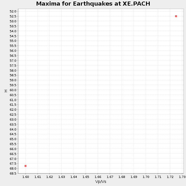
| Local Maxima 1 | 69 km | 1.60 | 6.454 km/s | 4.034 km/s | 0.18 | amp=0.019436259 |
| Local Maxima 2 | 30 km | 1.95 | 6.454 km/s | 3.318 km/s | 0.32 | amp=0.019018112 |
| Local Maxima 3 | 58 km | 2.03 | 6.454 km/s | 3.175 km/s | 0.34 | amp=0.01886764 |
| Local Maxima 4 | 50 km | 1.60 | 6.454 km/s | 4.034 km/s | 0.18 | amp=0.016359864 |
| Predicted Arrivals for vertical incidence (zero ray parameter) | |
| Ps | 5.90 SECOND |
| PpPs | 22.40 SECOND |
| PsPs/PpSs | 28.30 SECOND |
Events Processed for this Station
Download zip of receiver functions as SAC
Plot maxima for each earthquake.
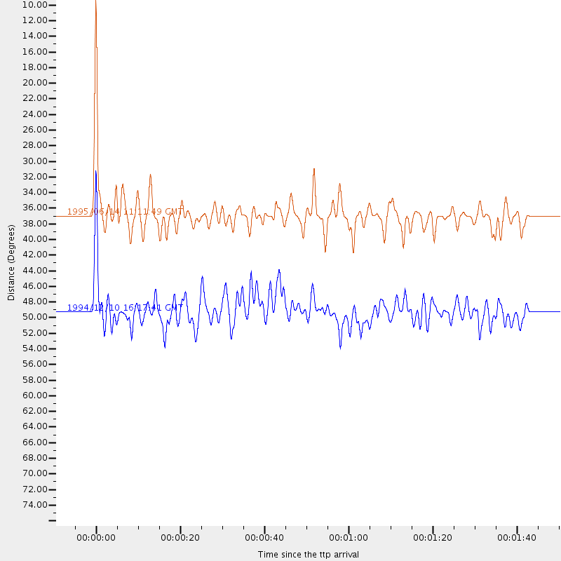
Events Used in the Stack
(2 events)| Radial Match | Distance | Baz | FERegion | Time | Lat/Lon | Depth | Magnitude |
| 85.875626 | 49.2 deg | 318.353 deg | Guerrero, Mexico | 1994/12/10 16:17:41 GMT | (18.2, -101.4) | 67 km | 6.5 MB, 6.6 UNKNOWN, 6.5 MW |
| 84.80782 | 36.9 deg | 328.124 deg | Off Coast Of Central America | 1995/06/14 11:11:49 GMT | (12.2, -88.3) | 39 km | 5.6 MB, 6.0 MS, 6.6 UNKNOWN |
Losers
(4 events)| Radial Match | Distance | Baz | FERegion | Time | Lat/Lon | Depth | Magnitude | Reason |
| 78.50432 | 50.0 deg | 73.866 deg | Central Mid-Atlantic Ridge | 1995/05/18 00:06:26 GMT | (-0.9, -22.0) | 10 km | 6.2 MB, 6.1 MS, 6.8 UNKNOWN, 6.7 MW | |
| 70.81776 | 59.4 deg | 218.4 deg | Pacific-Antarctic Ridge | 1995/05/09 12:29:57 GMT | (-54.0, -134.3) | 10 km | 5.4 MB, 5.7 MS, 5.9 UNKNOWN | |
| 70.484695 | 95.4 deg | 239.118 deg | South Of Fiji Islands | 1995/01/23 10:16:18 GMT | (-26.8, -176.4) | 33 km | 5.3 MB, 5.7 MS, 6.0 UNKNOWN, 5.8 MW | |
| 48.543587 | 47.6 deg | 149.614 deg | South Sandwich Islands Region | 1995/05/20 13:45:02 GMT | (-56.0, -27.7) | 100 km | 5.5 MB, 5.5 UNKNOWN |
