
Station XE ROSL - XE.ROSL
Network: XE94 - BBand Andean Joint Exp. / Seismic Exploration of Deep Andes
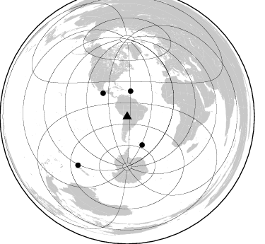
Nearby stations (2 deg radius)

| Station | Name | (Lat, Lon) | Start / End | Elevation |
| ROSL | XE.ROSL | (-19.49, -64.18) | 1994-03-27 / 1995-12-31 | 2073 m |
| Crust2 Type: | DC,Platform 0.5 km seds. |
| Thickness Estimate: | 46 km |
| Thickness StdDev: | 5.2 km |
| Vp/Vs Estimate: | 1.81 |
| Vp/Vs StdDev: | 0.08 |
| Vs Estimate: | 3.63 km/s |
| Poisson's Ratio: | 0.28 |
| Peak Value: | 0.04 |
| Assumed Vp: | 6.552 km/s |
| Ps Weight: | 0.33333334 |
| PpPs Weight: | 0.33333334 |
| PsPs Weight: | 0.33333328 |
| Residual Complexity: | 0.702 |
| Nearby stations H: | +- |
| (2.0 deg) Vp/Vs: | +- |
1 with match > 90% ( 12.5 %) and 4 with match > 80% ( 50.0 %) out of 8.
Download stack as xyz text file.
Azimuth Distribution of Events:
Prior Results for this Station
| Study | Thickness | Vp/Vs | Vp | Vs | Poissons Ratio | Extra |
| EARS | 46 km | 1.81 | 6.552 km/s | 3.63 km/s | 0.28 | |
| Crust2.0 | 41 km | 1.77 | 6.552 km/s | 3.698 km/s | 0.27 | DC,Platform 0.5 km seds. |
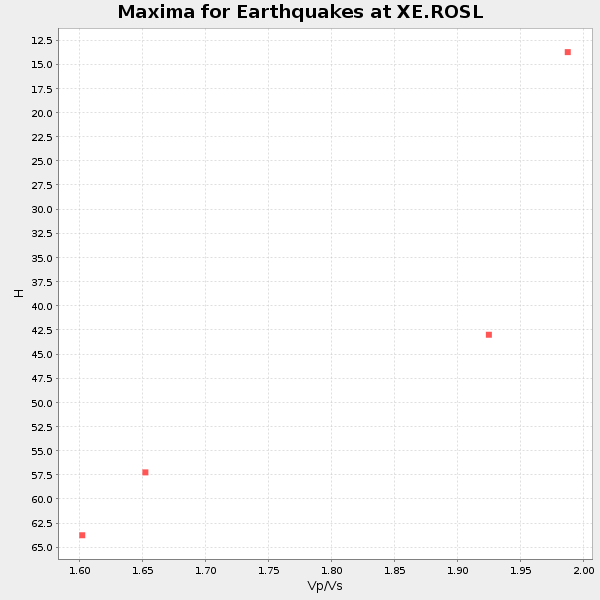
| Global Maxima | 46 km | 1.81 | 6.552 km/s | 3.63 km/s | 0.28 | amp=0.038194697 |
| Local Maxima 1 | 59 km | 1.62 | 6.552 km/s | 4.032 km/s | 0.20 | amp=0.030780938 |
| Local Maxima 2 | 42 km | 1.87 | 6.552 km/s | 3.504 km/s | 0.30 | amp=0.025905441 |
| Local Maxima 3 | 33 km | 2.08 | 6.552 km/s | 3.158 km/s | 0.35 | amp=0.022360342 |
| Local Maxima 4 | 36 km | 1.87 | 6.552 km/s | 3.509 km/s | 0.30 | amp=0.014711343 |
| Predicted Arrivals for vertical incidence (zero ray parameter) | |
| Ps | 5.62 SECOND |
| PpPs | 19.58 SECOND |
| PsPs/PpSs | 25.21 SECOND |
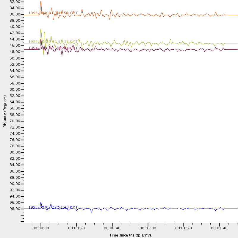
Events Processed for this Station
Download zip of receiver functions as SAC
Plot maxima for each earthquake.
Events Used in the Stack
(4 events)| Radial Match | Distance | Baz | FERegion | Time | Lat/Lon | Depth | Magnitude |
| 93.08075 | 97.9 deg | 225.492 deg | Off E. Coast Of N. Island, N.Z. | 1995/02/05 22:51:10 GMT | (-37.7, 178.8) | 59 km | 6.4 MB, 7.1 UNKNOWN, 7.1 MW |
| 84.1625 | 47.3 deg | 313.982 deg | Off Coast Of Oaxaca, Mexico | 1994/07/04 21:36:44 GMT | (14.9, -97.3) | 33 km | 6.1 MB, 6.1 MS, 6.5 UNKNOWN, 6.5 MD |
| 81.818375 | 45.2 deg | 152.186 deg | South Sandwich Islands Region | 1995/03/26 02:16:16 GMT | (-55.9, -28.2) | 77 km | 6.1 MB, 5.9 MS, 6.4 UNKNOWN, 6.3 MW |
| 80.8167 | 36.1 deg | 7.511 deg | Leeward Islands | 1995/03/08 03:45:59 GMT | (16.6, -59.6) | 15 km | 6.3 MB, 6.2 MS, 6.4 UNKNOWN, 6.1 MD |
Losers
(4 events)| Radial Match | Distance | Baz | FERegion | Time | Lat/Lon | Depth | Magnitude | Reason |
| 73.69982 | 52.3 deg | 313.485 deg | Guerrero, Mexico | 1994/12/10 16:17:41 GMT | (18.2, -101.4) | 67 km | 6.5 MB, 6.6 UNKNOWN, 6.5 MW | |
| 73.280624 | 38.2 deg | 181.544 deg | Drake Passage | 1995/01/03 16:11:59 GMT | (-57.7, -66.0) | 33 km | 6.1 MB, 5.6 MS, 6.1 UNKNOWN, 5.9 MW | |
| 64.78876 | 31.9 deg | 323.392 deg | South Of Panama | 1995/02/05 20:37:10 GMT | (6.8, -82.7) | 10 km | 5.8 MB, 5.4 MS, 6.1 UNKNOWN, 5.3 MD | |
| 41.44056 | 97.9 deg | 225.439 deg | Off E. Coast Of N. Island, N.Z. | 1995/02/06 10:43:57 GMT | (-37.8, 178.8) | 33 km | 5.7 MB, 5.8 MS, 6.0 UNKNOWN, 5.8 ML |
