
Station XE SALI - XE.SALI
Network: XE94 - BBand Andean Joint Exp. / Seismic Exploration of Deep Andes
Nearby stations (2 deg radius)
| Station | Name | (Lat, Lon) | Start / End | Elevation |
| SALI | XE.SALI | (-19.62, -67.72) | 1994-03-27 / 1995-12-31 | 3779 m |
| Crust2 Type: | RC,orogen/65km Tibet, 4.5 km seds. |
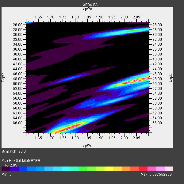
| Thickness Estimate: | 48 km |
| Thickness StdDev: | 13 km |
| Vp/Vs Estimate: | 2.05 |
| Vp/Vs StdDev: | 0.15 |
| Vs Estimate: | 3.083 km/s |
| Poisson's Ratio: | 0.34 |
| Peak Value: | 0.04 |
| Assumed Vp: | 6.319 km/s |
| Ps Weight: | 0.33333334 |
| PpPs Weight: | 0.33333334 |
| PsPs Weight: | 0.33333328 |
| Residual Complexity: | 0.745 |
| Nearby stations H: | +- |
| (2.0 deg) Vp/Vs: | +- |
0 with match > 90% ( 0.0 %) and 4 with match > 80% ( 44.444443 %) out of 9.
Download stack as xyz text file.
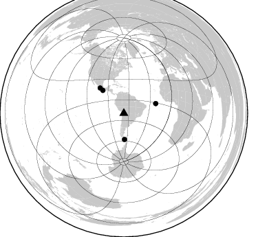
Azimuth Distribution of Events:
Prior Results for this Station
| Study | Thickness | Vp/Vs | Vp | Vs | Poissons Ratio | Extra |
| EARS | 48 km | 2.05 | 6.319 km/s | 3.083 km/s | 0.34 | |
| Crust2.0 | 65 km | 1.76 | 6.319 km/s | 3.593 km/s | 0.26 | RC,orogen/65km Tibet, 4.5 km seds. |
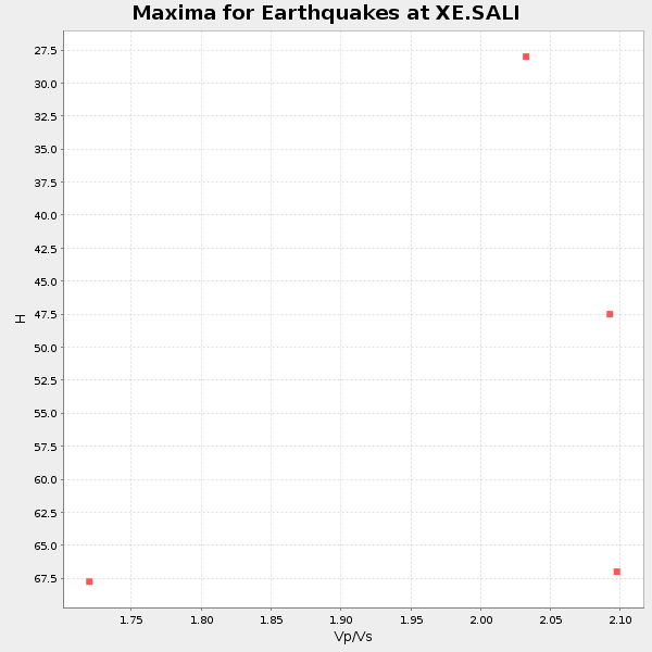
| Global Maxima | 48 km | 2.05 | 6.319 km/s | 3.083 km/s | 0.34 | amp=0.037552856 |
| Local Maxima 1 | 68 km | 1.79 | 6.319 km/s | 3.53 km/s | 0.27 | amp=0.03322672 |
| Local Maxima 2 | 28 km | 2.04 | 6.319 km/s | 3.094 km/s | 0.34 | amp=0.017632844 |
| Local Maxima 3 | 70 km | 1.72 | 6.319 km/s | 3.674 km/s | 0.24 | amp=0.016970206 |
| Local Maxima 4 | 50 km | 2.10 | 6.319 km/s | 3.013 km/s | 0.35 | amp=0.013509105 |
| Predicted Arrivals for vertical incidence (zero ray parameter) | |
| Ps | 8.06 SECOND |
| PpPs | 23.41 SECOND |
| PsPs/PpSs | 31.47 SECOND |
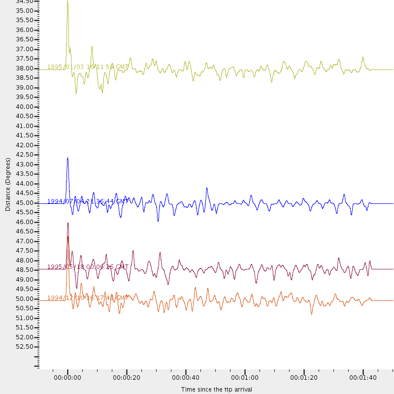
Events Processed for this Station
Download zip of receiver functions as SAC
Plot maxima for each earthquake.
Events Used in the Stack
(4 events)| Radial Match | Distance | Baz | FERegion | Time | Lat/Lon | Depth | Magnitude |
| 87.529274 | 38.0 deg | 178.461 deg | Drake Passage | 1995/01/03 16:11:59 GMT | (-57.7, -66.0) | 33 km | 6.1 MB, 5.6 MS, 6.1 UNKNOWN, 5.9 MW |
| 86.46856 | 50.1 deg | 316.644 deg | Guerrero, Mexico | 1994/12/10 16:17:41 GMT | (18.2, -101.4) | 67 km | 6.5 MB, 6.6 UNKNOWN, 6.5 MW |
| 84.70465 | 45.0 deg | 317.553 deg | Off Coast Of Oaxaca, Mexico | 1994/07/04 21:36:44 GMT | (14.9, -97.3) | 33 km | 6.1 MB, 6.1 MS, 6.5 UNKNOWN, 6.5 MD |
| 80.263 | 48.4 deg | 73.112 deg | Central Mid-Atlantic Ridge | 1995/05/18 00:06:26 GMT | (-0.9, -22.0) | 10 km | 6.2 MB, 6.1 MS, 6.8 UNKNOWN, 6.7 MW |
Losers
(5 events)| Radial Match | Distance | Baz | FERegion | Time | Lat/Lon | Depth | Magnitude | Reason |
| 98.27288 | 96.9 deg | 238.484 deg | South Of Fiji Islands | 1995/01/23 10:16:18 GMT | (-26.8, -176.4) | 33 km | 5.3 MB, 5.7 MS, 6.0 UNKNOWN, 5.8 MW | |
| 74.073524 | 47.0 deg | 150.432 deg | South Sandwich Islands Region | 1995/05/20 13:45:02 GMT | (-56.0, -27.7) | 100 km | 5.5 MB, 5.5 UNKNOWN | |
| 71.80678 | 94.6 deg | 202.854 deg | Macquarie Island Region | 1994/11/05 02:16:01 GMT | (-57.2, 157.7) | 10 km | 6.2 MB, 6.1 MS, 6.6 UNKNOWN, 6.4 MW | |
| 63.481762 | 46.7 deg | 150.467 deg | South Sandwich Islands Region | 1995/03/26 02:16:16 GMT | (-55.9, -28.2) | 77 km | 6.1 MB, 5.9 MS, 6.4 UNKNOWN, 6.3 MW | |
| 40.938072 | 94.3 deg | 45.678 deg | Corsica, France | 1995/05/02 12:28:27 GMT | (43.2, 9.4) | 10 km | 5.9 UNKNOWN, 5.9 MW |
