
Station XE SCHO - XE.SCHO
Network: XE94 - BBand Andean Joint Exp. / Seismic Exploration of Deep Andes
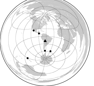
Nearby stations (2 deg radius)
| Station | Name | (Lat, Lon) | Start / End | Elevation |
| SCHO | XE.SCHO | (-19.15, -64.64) | 1994-03-27 / 1995-12-31 | 2591 m |
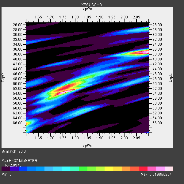
| Crust2 Type: | DC,Platform 0.5 km seds. |
| Thickness Estimate: | 37 km |
| Thickness StdDev: | 6.9 km |
| Vp/Vs Estimate: | 2.10 |
| Vp/Vs StdDev: | 0.14 |
| Vs Estimate: | 3.124 km/s |
| Poisson's Ratio: | 0.35 |
| Peak Value: | 0.02 |
| Assumed Vp: | 6.552 km/s |
| Ps Weight: | 0.33333334 |
| PpPs Weight: | 0.33333334 |
| PsPs Weight: | 0.33333328 |
| Residual Complexity: | 0.811 |
| Nearby stations H: | +- |
| (2.0 deg) Vp/Vs: | +- |
2 with match > 90% ( 15.384615 %) and 5 with match > 80% ( 38.46154 %) out of 13.
Download stack as xyz text file.
Azimuth Distribution of Events:
Prior Results for this Station
| Study | Thickness | Vp/Vs | Vp | Vs | Poissons Ratio | Extra |
| EARS | 37 km | 2.10 | 6.552 km/s | 3.124 km/s | 0.35 | |
| Crust2.0 | 41 km | 1.77 | 6.552 km/s | 3.698 km/s | 0.27 | DC,Platform 0.5 km seds. |
| Global Maxima | 37 km | 2.10 | 6.552 km/s | 3.124 km/s | 0.35 | amp=0.016855264 |
| Local Maxima 1 | 53 km | 1.76 | 6.552 km/s | 3.712 km/s | 0.26 | amp=0.015880909 |
| Local Maxima 2 | 52 km | 1.75 | 6.552 km/s | 3.739 km/s | 0.26 | amp=0.010317256 |
| Local Maxima 3 | 27 km | 2.10 | 6.552 km/s | 3.124 km/s | 0.35 | amp=0.008956078 |
| Local Maxima 4 | 61 km | 1.83 | 6.552 km/s | 3.581 km/s | 0.29 | amp=0.00784524 |
| Predicted Arrivals for vertical incidence (zero ray parameter) | |
| Ps | 6.20 SECOND |
| PpPs | 17.49 SECOND |
| PsPs/PpSs | 23.69 SECOND |
Events Processed for this Station
Download zip of receiver functions as SAC
Plot maxima for each earthquake.
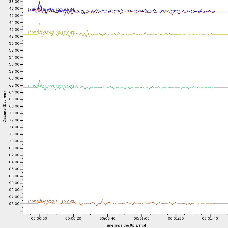
Events Used in the Stack
(5 events)| Radial Match | Distance | Baz | FERegion | Time | Lat/Lon | Depth | Magnitude |
| 95.47508 | 97.9 deg | 225.72 deg | Off E. Coast Of N. Island, N.Z. | 1995/02/05 22:51:10 GMT | (-37.7, 178.8) | 59 km | 6.4 MB, 7.1 UNKNOWN, 7.1 MW |
| 94.31386 | 45.7 deg | 152.111 deg | South Sandwich Islands Region | 1995/03/26 02:16:16 GMT | (-55.9, -28.2) | 77 km | 6.1 MB, 5.9 MS, 6.4 UNKNOWN, 6.3 MW |
| 89.47531 | 62.2 deg | 312.651 deg | Baja California, Mexico | 1995/06/30 11:58:56 GMT | (24.6, -110.3) | 10 km | 5.8 MB, 6.3 MS, 6.2 UNKNOWN |
| 84.30463 | 38.9 deg | 321.291 deg | Off Coast Of Central America | 1995/06/14 11:11:49 GMT | (12.2, -88.3) | 39 km | 5.6 MB, 6.0 MS, 6.6 UNKNOWN |
| 81.19588 | 38.5 deg | 181.133 deg | Drake Passage | 1995/01/03 16:11:59 GMT | (-57.7, -66.0) | 33 km | 6.1 MB, 5.6 MS, 6.1 UNKNOWN, 5.9 MW |
Losers
(8 events)| Radial Match | Distance | Baz | FERegion | Time | Lat/Lon | Depth | Magnitude | Reason |
| 93.65608 | 46.7 deg | 314.194 deg | Off Coast Of Oaxaca, Mexico | 1994/07/04 21:36:44 GMT | (14.9, -97.3) | 33 km | 6.1 MB, 6.1 MS, 6.5 UNKNOWN, 6.5 MD | |
| 91.78548 | 56.5 deg | 309.585 deg | Off Coast Of Jalisco, Mexico | 1995/05/31 16:08:40 GMT | (18.9, -107.4) | 33 km | 5.4 MB, 6.1 MS, 6.3 UNKNOWN, 6.3 MW | |
| 89.063965 | 51.8 deg | 313.684 deg | Guerrero, Mexico | 1994/12/10 16:17:41 GMT | (18.2, -101.4) | 67 km | 6.5 MB, 6.6 UNKNOWN, 6.5 MW | |
| 78.75826 | 62.8 deg | 218.515 deg | Pacific-Antarctic Ridge | 1995/05/09 12:29:57 GMT | (-54.0, -134.3) | 10 km | 5.4 MB, 5.7 MS, 5.9 UNKNOWN | |
| 71.221 | 46.0 deg | 152.048 deg | South Sandwich Islands Region | 1995/05/20 13:45:02 GMT | (-56.0, -27.7) | 100 km | 5.5 MB, 5.5 UNKNOWN | |
| 71.2038 | 51.0 deg | 308.234 deg | Off Coast Of Guerrero, Mexico | 1994/10/28 09:11:20 GMT | (14.6, -103.7) | 33 km | 5.5 MS, 5.2 MB | |
| 67.80817 | 41.3 deg | 335.074 deg | Caribbean Sea | 1995/06/27 10:09:58 GMT | (18.8, -81.7) | 10 km | 5.7 MB, 5.6 MS, 6.2 UNKNOWN, 6.1 MW | |
| 67.43726 | 56.9 deg | 214.808 deg | Southern East Pacific Rise | 1995/01/04 06:28:39 GMT | (-56.1, -123.2) | 10 km | 5.8 MS, 5.1 MB, 6.0 UNKNOWN |
