
Station XE YUNZ - XE.YUNZ
Network: XE94 - BBand Andean Joint Exp. / Seismic Exploration of Deep Andes
Nearby stations (2 deg radius)

| Station | Name | (Lat, Lon) | Start / End | Elevation |
| YUNZ | XE.YUNZ | (-19.16, -65.07) | 1994-03-27 / 1995-12-31 | 2896 m |
| Crust2 Type: | DC,Platform 0.5 km seds. |
| Thickness Estimate: | 52 km |
| Thickness StdDev: | 4.8 km |
| Vp/Vs Estimate: | 1.90 |
| Vp/Vs StdDev: | 0.05 |
| Vs Estimate: | 3.44 km/s |
| Poisson's Ratio: | 0.31 |
| Peak Value: | 0.09 |
| Assumed Vp: | 6.552 km/s |
| Ps Weight: | 0.33333334 |
| PpPs Weight: | 0.33333334 |
| PsPs Weight: | 0.33333328 |
| Residual Complexity: | 0.284 |
| Nearby stations H: | +- |
| (2.0 deg) Vp/Vs: | +- |
2 with match > 90% ( 20.0 %) and 3 with match > 80% ( 30.0 %) out of 10.
Download stack as xyz text file.
Azimuth Distribution of Events:
Prior Results for this Station
| Study | Thickness | Vp/Vs | Vp | Vs | Poissons Ratio | Extra |
| EARS | 52 km | 1.90 | 6.552 km/s | 3.44 km/s | 0.31 | |
| Crust2.0 | 41 km | 1.77 | 6.552 km/s | 3.698 km/s | 0.27 | DC,Platform 0.5 km seds. |
| Global Maxima | 52 km | 1.90 | 6.552 km/s | 3.44 km/s | 0.31 | amp=0.09362093 |
| Local Maxima 1 | 54 km | 1.89 | 6.552 km/s | 3.471 km/s | 0.30 | amp=0.031132504 |
| Local Maxima 2 | 32 km | 2.08 | 6.552 km/s | 3.158 km/s | 0.35 | amp=0.016357379 |
| Local Maxima 3 | 60 km | 1.95 | 6.552 km/s | 3.369 km/s | 0.32 | amp=0.010479781 |
| Local Maxima 4 | 49 km | 1.68 | 6.552 km/s | 3.894 km/s | 0.23 | amp=0.007508305 |
| Predicted Arrivals for vertical incidence (zero ray parameter) | |
| Ps | 7.18 SECOND |
| PpPs | 23.05 SECOND |
| PsPs/PpSs | 30.24 SECOND |
Events Processed for this Station
Download zip of receiver functions as SAC
Plot maxima for each earthquake.
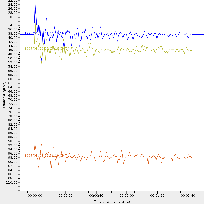
Events Used in the Stack
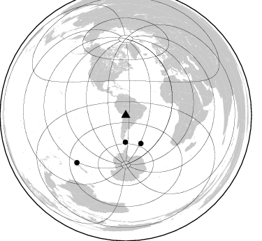
(3 events)| Radial Match | Distance | Baz | FERegion | Time | Lat/Lon | Depth | Magnitude |
| 90.86185 | 38.5 deg | 180.766 deg | Drake Passage | 1995/01/03 16:11:59 GMT | (-57.7, -66.0) | 33 km | 6.1 MB, 5.6 MS, 6.1 UNKNOWN, 5.9 MW |
| 90.04573 | 45.9 deg | 151.9 deg | South Sandwich Islands Region | 1995/03/26 02:16:16 GMT | (-55.9, -28.2) | 77 km | 6.1 MB, 5.9 MS, 6.4 UNKNOWN, 6.3 MW |
| 85.14769 | 97.6 deg | 225.896 deg | Off E. Coast Of N. Island, N.Z. | 1995/02/05 22:51:10 GMT | (-37.7, 178.8) | 59 km | 6.4 MB, 7.1 UNKNOWN, 7.1 MW |
Losers
(7 events)| Radial Match | Distance | Baz | FERegion | Time | Lat/Lon | Depth | Magnitude | Reason |
| 82.73037 | 46.4 deg | 314.606 deg | Off Coast Of Oaxaca, Mexico | 1994/07/04 21:36:44 GMT | (14.9, -97.3) | 33 km | 6.1 MB, 6.1 MS, 6.5 UNKNOWN, 6.5 MD | |
| 77.87229 | 51.5 deg | 314.049 deg | Guerrero, Mexico | 1994/12/10 16:17:41 GMT | (18.2, -101.4) | 67 km | 6.5 MB, 6.6 UNKNOWN, 6.5 MW | |
| 77.35511 | 56.2 deg | 147.529 deg | Southwestern Atlantic Ocean | 1994/09/15 23:47:30 GMT | (-57.8, -8.7) | 10 km | 5.6 MS, 5.2 MB | |
| 74.80483 | 97.6 deg | 225.554 deg | Off E. Coast Of N. Island, N.Z. | 1995/02/10 01:45:04 GMT | (-38.0, 178.5) | 33 km | 5.8 MB, 6.4 MS, 6.5 UNKNOWN, 6.3 ML | |
| 57.12252 | 31.1 deg | 324.48 deg | South Of Panama | 1995/02/05 20:37:10 GMT | (6.8, -82.7) | 10 km | 5.8 MB, 5.4 MS, 6.1 UNKNOWN, 5.3 MD | |
| 52.617634 | 46.2 deg | 151.841 deg | South Sandwich Islands Region | 1995/05/20 13:45:02 GMT | (-56.0, -27.7) | 100 km | 5.5 MB, 5.5 UNKNOWN | |
| 51.73608 | 50.7 deg | 308.582 deg | Off Coast Of Guerrero, Mexico | 1994/10/28 09:11:20 GMT | (14.6, -103.7) | 33 km | 5.5 MS, 5.2 MB |
