
Station XE AND - Anderson
Network: XE99 - Broadband Experiment Across Alaskan Range
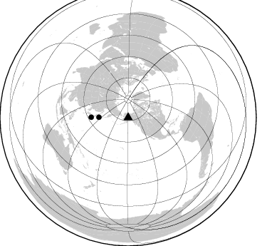
Nearby stations (2 deg radius)
| Station | Name | (Lat, Lon) | Start / End | Elevation |
| AND | Anderson | (64.33, -149.20) | 2000-05-22 / 2001-12-31 | 178 m |
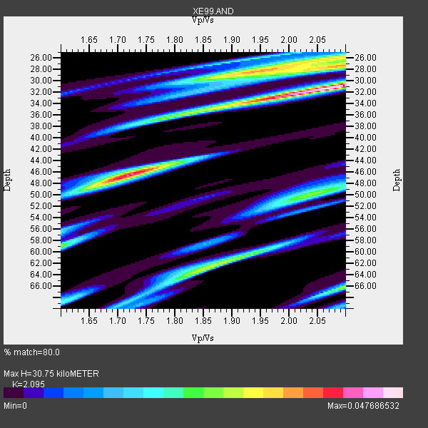
| Crust2 Type: | L8,thin continental arc, Cordilleras, 0.5 km seds. |
| Thickness Estimate: | 31 km |
| Thickness StdDev: | 10 km |
| Vp/Vs Estimate: | 2.10 |
| Vp/Vs StdDev: | 0.04 |
| Vs Estimate: | 3.134 km/s |
| Poisson's Ratio: | 0.35 |
| Peak Value: | 0.05 |
| Assumed Vp: | 6.566 km/s |
| Ps Weight: | 0.33333334 |
| PpPs Weight: | 0.33333334 |
| PsPs Weight: | 0.33333328 |
| Residual Complexity: | 0.882 |
| Nearby stations H: | +- |
| (2.0 deg) Vp/Vs: | +- |
1 with match > 90% ( 50.0 %) and 2 with match > 80% ( 100.0 %) out of 2.
Download stack as xyz text file.
Azimuth Distribution of Events:
Prior Results for this Station
| Study | Thickness | Vp/Vs | Vp | Vs | Poissons Ratio | Extra |
| EARS | 31 km | 2.10 | 6.566 km/s | 3.134 km/s | 0.35 | |
| Crust2.0 | 34 km | 1.77 | 6.566 km/s | 3.707 km/s | 0.27 | L8,thin continental arc, Cordilleras, 0.5 km seds. |
| Global Maxima | 31 km | 2.10 | 6.566 km/s | 3.134 km/s | 0.35 | amp=0.047686532 |
| Local Maxima 1 | 46 km | 1.72 | 6.566 km/s | 3.829 km/s | 0.24 | amp=0.039308142 |
| Local Maxima 2 | 28 km | 1.94 | 6.566 km/s | 3.38 km/s | 0.32 | amp=0.03442204 |
| Local Maxima 3 | 62 km | 1.86 | 6.566 km/s | 3.53 km/s | 0.30 | amp=0.028547984 |
| Local Maxima 4 | 66 km | 2.10 | 6.566 km/s | 3.134 km/s | 0.35 | amp=0.02661793 |
| Predicted Arrivals for vertical incidence (zero ray parameter) | |
| Ps | 5.13 SECOND |
| PpPs | 14.49 SECOND |
| PsPs/PpSs | 19.62 SECOND |
Events Processed for this Station
Download zip of receiver functions as SAC
Plot maxima for each earthquake.
Events Used in the Stack
(2 events)| Radial Match | Distance | Baz | FERegion | Time | Lat/Lon | Depth | Magnitude |
| 92.77907 | 41.2 deg | 270.641 deg | Kuril Islands | 2000/08/15 20:20:43 GMT | (43.0, 146.8) | 33 km | 5.7 MB, 5.3 MS, 5.9 MW, 5.8 MW |
| 81.195076 | 52.0 deg | 270.565 deg | Near S. Coast Of Honshu, Japan | 2000/07/08 18:57:44 GMT | (34.1, 139.1) | 10 km | 5.9 MB, 5.6 MS, 6.0 MW, 5.9 MW |
Losers
(0 events)| Radial Match | Distance | Baz | FERegion | Time | Lat/Lon | Depth | Magnitude | Reason |
