
Station XE DH1 - Denali Highway 1
Network: XE99 - Broadband Experiment Across Alaskan Range
Nearby stations (2 deg radius)
| Station | Name | (Lat, Lon) | Start / End | Elevation |
| DH1 | Denali Highway 1 | (63.37, -148.38) | 2000-05-27 / 2001-12-31 | 756 m |
| Crust2 Type: | L8,thin continental arc, Cordilleras, 0.5 km seds. |
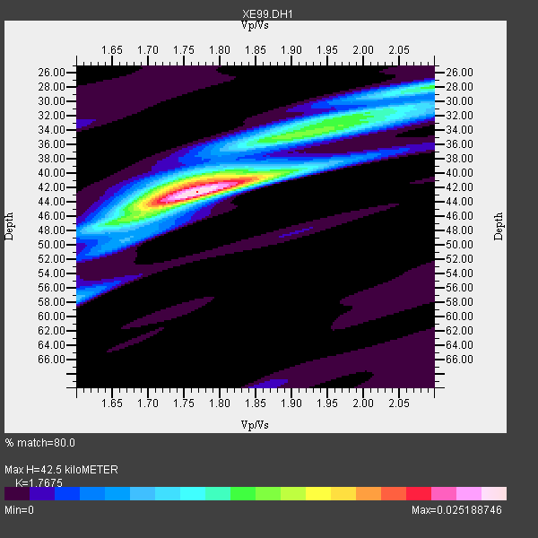
| Thickness Estimate: | 42 km |
| Thickness StdDev: | 2.4 km |
| Vp/Vs Estimate: | 1.77 |
| Vp/Vs StdDev: | 0.05 |
| Vs Estimate: | 3.715 km/s |
| Poisson's Ratio: | 0.26 |
| Peak Value: | 0.03 |
| Assumed Vp: | 6.566 km/s |
| Ps Weight: | 0.33333334 |
| PpPs Weight: | 0.33333334 |
| PsPs Weight: | 0.33333328 |
| Residual Complexity: | 0.592 |
| Nearby stations H: | +- |
| (2.0 deg) Vp/Vs: | +- |
12 with match > 90% ( 37.5 %) and 32 with match > 80% ( 100.0 %) out of 32.
Download stack as xyz text file.
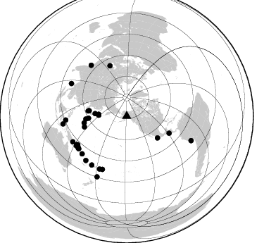
Azimuth Distribution of Events:
Prior Results for this Station
| Study | Thickness | Vp/Vs | Vp | Vs | Poissons Ratio | Extra |
| EARS | 42 km | 1.77 | 6.566 km/s | 3.715 km/s | 0.26 | |
| Crust2.0 | 34 km | 1.77 | 6.566 km/s | 3.707 km/s | 0.27 | L8,thin continental arc, Cordilleras, 0.5 km seds. |
| Global Maxima | 42 km | 1.77 | 6.566 km/s | 3.715 km/s | 0.26 | amp=0.025188746 |
| Local Maxima 1 | 34 km | 1.91 | 6.566 km/s | 3.442 km/s | 0.31 | amp=0.013172497 |
| Local Maxima 2 | 46 km | 1.66 | 6.566 km/s | 3.95 km/s | 0.22 | amp=0.010596346 |
| Local Maxima 3 | 41 km | 1.77 | 6.566 km/s | 3.699 km/s | 0.27 | amp=0.009413994 |
| Local Maxima 4 | 32 km | 1.99 | 6.566 km/s | 3.3 km/s | 0.33 | amp=0.008243038 |
| Predicted Arrivals for vertical incidence (zero ray parameter) | |
| Ps | 4.97 SECOND |
| PpPs | 17.91 SECOND |
| PsPs/PpSs | 22.88 SECOND |
Events Processed for this Station
Download zip of receiver functions as SAC
Plot maxima for each earthquake.
Events Used in the Stack
(32 events)| Radial Match | Distance | Baz | FERegion | Time | Lat/Lon | Depth | Magnitude |
| 97.080284 | 65.1 deg | 111.855 deg | El Salvador | 2001/01/13 17:33:32 GMT | (13.0, -88.7) | 60 km | 6.4 MB, 7.8 MS, 7.7 MW, 7.5 ME |
| 96.18209 | 97.7 deg | 110.75 deg | Near Coast Of Peru | 2001/06/23 20:33:14 GMT | (-16.3, -73.6) | 33 km | 6.7 MB, 8.2 MS, 8.4 MW, 7.8 ME |
| 95.15642 | 81.0 deg | 239.193 deg | New Ireland Region, P.N.G. | 2000/11/16 05:21:22 GMT | (-5.1, 153.2) | 33 km | 6.0 MB |
| 94.63308 | 86.8 deg | 266.431 deg | Northern Molucca Sea | 2001/02/24 07:23:48 GMT | (1.3, 126.2) | 35 km | 6.6 MB, 7.0 MS, 7.1 MW, 7.1 ME |
| 93.88434 | 75.7 deg | 341.702 deg | Turkmenistan | 2000/12/06 17:11:06 GMT | (39.6, 54.8) | 30 km | 6.7 MB, 7.5 MS, 7.0 MW, 6.9 ME |
| 93.2824 | 39.9 deg | 272.187 deg | Kuril Islands | 2001/05/25 00:40:50 GMT | (44.3, 148.4) | 33 km | 6.1 MB, 6.7 MS, 6.7 MW, 6.6 MW |
| 93.10155 | 81.9 deg | 240.376 deg | New Britain Region, P.N.G. | 2000/11/17 21:01:56 GMT | (-5.5, 151.8) | 33 km | 6.2 MB, 8.0 MS, 7.6 MW, 6.9 ME |
| 92.14574 | 88.3 deg | 325.004 deg | Southern India | 2001/01/26 03:16:40 GMT | (23.4, 70.2) | 16 km | 6.9 MB, 8.0 MS, 7.7 MW, 7.7 ME |
| 92.08613 | 82.1 deg | 236.769 deg | Solomon Islands | 2001/05/29 23:37:19 GMT | (-7.0, 155.0) | 14 km | 5.7 MB, 6.4 MS, 6.4 MW, 5.7 ME |
| 90.504135 | 85.3 deg | 222.783 deg | Vanuatu Islands | 2001/01/09 16:49:28 GMT | (-14.9, 167.2) | 103 km | 6.3 MB, 6.6 MS, 7.6 ME, 7.0 MW |
| 90.41994 | 91.0 deg | 263.008 deg | Banda Sea | 2000/08/28 15:05:47 GMT | (-4.1, 127.4) | 16 km | 6.5 MB, 6.8 MS, 6.8 MW, 6.7 ME |
| 90.296844 | 82.1 deg | 235.854 deg | Solomon Islands | 2001/04/19 21:43:42 GMT | (-7.4, 155.9) | 17 km | 6.0 MB, 6.6 MS, 6.7 MW, 6.2 ME |
| 89.38586 | 82.9 deg | 239.615 deg | New Britain Region, P.N.G. | 2001/07/08 17:54:18 GMT | (-6.7, 152.1) | 10 km | 6.0 MB, 5.7 MS, 6.2 MW, 5.7 ML |
| 89.31706 | 54.6 deg | 267.062 deg | Southeast Of Honshu, Japan | 2001/04/14 23:27:26 GMT | (30.1, 141.8) | 10 km | 6.0 MB, 5.8 MS, 6.0 MW, 6.0 ME |
| 89.246315 | 80.4 deg | 239.752 deg | New Britain Region, P.N.G. | 2001/07/01 01:46:06 GMT | (-4.3, 153.0) | 28 km | 5.8 MB, 6.0 MS, 6.1 MW, 6.0 ME |
| 88.567856 | 45.2 deg | 274.539 deg | Hokkaido, Japan Region | 2001/08/13 20:11:23 GMT | (41.0, 142.3) | 38 km | 6.0 MB, 6.3 MS, 6.4 MW, 6.3 ME |
| 88.54242 | 82.3 deg | 236.808 deg | Solomon Islands | 2001/06/01 20:36:56 GMT | (-7.2, 154.9) | 33 km | 5.6 MB, 5.7 MS, 5.9 MW, 5.8 MW |
| 88.07621 | 55.3 deg | 277.764 deg | Western Honshu, Japan | 2001/03/24 06:27:53 GMT | (34.1, 132.5) | 50 km | 6.4 MB, 6.5 MS, 6.8 MW, 6.4 ME |
| 87.885994 | 95.8 deg | 206.149 deg | Kermadec Islands, New Zealand | 2001/06/03 02:41:57 GMT | (-29.7, -178.6) | 178 km | 6.8 MB, 7.2 MW, 7.1 MW |
| 87.238144 | 62.0 deg | 255.731 deg | Mariana Islands | 2001/06/15 06:17:45 GMT | (18.8, 147.0) | 33 km | 5.4 MB, 5.9 MS, 6.0 MW, 6.0 MW |
| 86.75371 | 82.9 deg | 229.812 deg | Solomon Islands | 2001/05/09 17:38:26 GMT | (-10.3, 161.2) | 68 km | 6.0 MB, 5.9 MS, 6.3 MW, 6.2 MW |
| 85.68782 | 82.7 deg | 204.554 deg | Tonga Islands | 2000/09/26 06:17:52 GMT | (-17.2, -173.9) | 56 km | 6.1 MB, 6.1 MS, 6.4 MW, 6.1 ME |
| 85.23459 | 61.3 deg | 260.989 deg | Mariana Islands Region | 2001/07/03 13:10:42 GMT | (21.6, 143.0) | 290 km | 6.0 MB, 6.5 MW, 6.5 MW |
| 84.78346 | 39.9 deg | 272.008 deg | Kuril Islands | 2001/06/24 13:18:51 GMT | (44.2, 148.5) | 33 km | 5.8 MB, 5.7 MS, 6.0 MW |
| 84.60159 | 84.8 deg | 244.614 deg | Eastern New Guinea Reg., P.N.G. | 2001/06/30 16:34:36 GMT | (-6.4, 146.8) | 104 km | 5.8 MB, 6.0 MW, 6.0 MW |
| 84.28288 | 53.9 deg | 278.159 deg | Western Honshu, Japan | 2000/10/06 04:30:19 GMT | (35.5, 133.1) | 10 km | 5.8 MB, 6.8 MS, 7.0 ME, 6.7 MW |
| 82.712616 | 53.6 deg | 125.249 deg | Near Coast Of Jalisco, Mexico | 2001/05/20 04:21:43 GMT | (18.8, -104.4) | 33 km | 5.5 MB, 6.0 MS, 6.5 MD, 6.3 MW |
| 82.573135 | 85.0 deg | 215.624 deg | Fiji Islands Region | 2000/08/09 22:55:59 GMT | (-16.8, 174.3) | 33 km | 5.7 MB, 6.3 MS, 6.4 MW, 6.4 MW |
| 82.03957 | 91.2 deg | 300.544 deg | Andaman Islands, India Region | 2001/08/05 05:16:16 GMT | (12.2, 93.4) | 96 km | 5.4 MB, 5.2 MS, 6.0 MW, 5.9 MW |
| 81.36517 | 58.4 deg | 265.923 deg | Bonin Islands, Japan Region | 2000/10/27 04:21:51 GMT | (26.3, 140.5) | 388 km | 6.1 MB, 6.1 MW, 6.0 MW |
| 81.17283 | 84.2 deg | 207.198 deg | Fiji Islands Region | 2001/04/28 04:49:53 GMT | (-18.1, -176.9) | 352 km | 6.2 MB, 6.8 MW, 6.8 MW |
| 80.28797 | 40.1 deg | 273.733 deg | Kuril Islands | 2000/12/22 10:13:01 GMT | (44.8, 147.2) | 140 km | 6.0 MB, 6.2 MW, 6.2 MW |
Losers
(0 events)| Radial Match | Distance | Baz | FERegion | Time | Lat/Lon | Depth | Magnitude | Reason |
