
Station XE MHR - Moosehead Rock
Network: XE99 - Broadband Experiment Across Alaskan Range
Nearby stations (2 deg radius)
| Station | Name | (Lat, Lon) | Start / End | Elevation |
| MHR | Moosehead Rock | (62.86, -149.86) | 2000-05-31 / 2001-12-31 | 378 m |
| Crust2 Type: | L8,thin continental arc, Cordilleras, 0.5 km seds. |
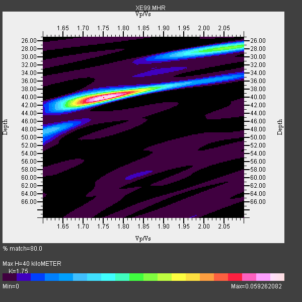
| Thickness Estimate: | 40 km |
| Thickness StdDev: | 0.3 km |
| Vp/Vs Estimate: | 1.75 |
| Vp/Vs StdDev: | 0.01 |
| Vs Estimate: | 3.752 km/s |
| Poisson's Ratio: | 0.26 |
| Peak Value: | 0.06 |
| Assumed Vp: | 6.566 km/s |
| Ps Weight: | 0.33333334 |
| PpPs Weight: | 0.33333334 |
| PsPs Weight: | 0.33333328 |
| Residual Complexity: | 0.433 |
| Nearby stations H: | +- |
| (2.0 deg) Vp/Vs: | +- |
6 with match > 90% ( 35.294117 %) and 17 with match > 80% ( 100.0 %) out of 17.
Download stack as xyz text file.
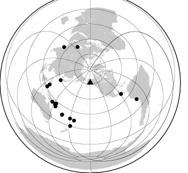
Azimuth Distribution of Events:
Prior Results for this Station
| Study | Thickness | Vp/Vs | Vp | Vs | Poissons Ratio | Extra |
| EARS | 40 km | 1.75 | 6.566 km/s | 3.752 km/s | 0.26 | |
| Crust2.0 | 34 km | 1.77 | 6.566 km/s | 3.707 km/s | 0.27 | L8,thin continental arc, Cordilleras, 0.5 km seds. |
| Global Maxima | 40 km | 1.75 | 6.566 km/s | 3.752 km/s | 0.26 | amp=0.059262082 |
| Local Maxima 1 | 28 km | 2.05 | 6.566 km/s | 3.207 km/s | 0.34 | amp=0.029528987 |
| Local Maxima 2 | 40 km | 1.72 | 6.566 km/s | 3.829 km/s | 0.24 | amp=0.015069342 |
| Local Maxima 3 | 35 km | 2.05 | 6.566 km/s | 3.203 km/s | 0.34 | amp=0.007616883 |
| Local Maxima 4 | 42 km | 1.71 | 6.566 km/s | 3.851 km/s | 0.24 | amp=0.0069862544 |
| Predicted Arrivals for vertical incidence (zero ray parameter) | |
| Ps | 4.57 SECOND |
| PpPs | 16.75 SECOND |
| PsPs/PpSs | 21.32 SECOND |
Events Processed for this Station
Download zip of receiver functions as SAC
Plot maxima for each earthquake.
Events Used in the Stack
(17 events)| Radial Match | Distance | Baz | FERegion | Time | Lat/Lon | Depth | Magnitude |
| 96.1572 | 65.5 deg | 110.202 deg | El Salvador | 2001/01/13 17:33:32 GMT | (13.0, -88.7) | 60 km | 6.4 MB, 7.8 MS, 7.7 MW, 7.5 ME |
| 94.59334 | 86.1 deg | 265.14 deg | Northern Molucca Sea | 2001/02/24 07:23:48 GMT | (1.3, 126.2) | 35 km | 6.6 MB, 7.0 MS, 7.1 MW, 7.1 ME |
| 94.45196 | 98.2 deg | 109.531 deg | Near Coast Of Peru | 2001/06/23 20:33:14 GMT | (-16.3, -73.6) | 33 km | 6.7 MB, 8.2 MS, 8.4 MW, 7.8 ME |
| 91.90549 | 76.0 deg | 340.585 deg | Turkmenistan | 2000/12/06 17:11:06 GMT | (39.6, 54.8) | 30 km | 6.7 MB, 7.5 MS, 7.0 MW, 6.9 ME |
| 91.48783 | 81.1 deg | 239.071 deg | New Britain Region, P.N.G. | 2000/11/17 21:01:56 GMT | (-5.5, 151.8) | 33 km | 6.2 MB, 8.0 MS, 7.6 MW, 6.9 ME |
| 90.675735 | 81.0 deg | 267.429 deg | Mindanao, Philippines | 2001/01/01 06:57:04 GMT | (6.9, 126.6) | 33 km | 6.4 MB, 7.2 MS, 7.5 MW, 7.3 ME |
| 89.24306 | 88.3 deg | 323.708 deg | Southern India | 2001/01/26 03:16:40 GMT | (23.4, 70.2) | 16 km | 6.9 MB, 8.0 MS, 7.7 MW, 7.7 ME |
| 89.01732 | 95.0 deg | 204.866 deg | Kermadec Islands, New Zealand | 2001/06/03 02:41:57 GMT | (-29.7, -178.6) | 178 km | 6.8 MB, 7.2 MW, 7.1 MW |
| 88.80526 | 82.0 deg | 203.179 deg | Tonga Islands | 2000/09/26 06:17:52 GMT | (-17.2, -173.9) | 56 km | 6.1 MB, 6.1 MS, 6.4 MW, 6.1 ME |
| 88.785225 | 84.4 deg | 221.449 deg | Vanuatu Islands | 2001/01/09 16:49:28 GMT | (-14.9, 167.2) | 103 km | 6.3 MB, 6.6 MS, 7.6 ME, 7.0 MW |
| 88.189415 | 59.2 deg | 274.839 deg | Southeast Of Ryukyu Islands | 2000/06/06 14:57:02 GMT | (29.4, 131.4) | 33 km | 5.8 MB, 6.0 MS, 6.4 MW, 6.4 MW |
| 86.34036 | 79.5 deg | 238.449 deg | New Britain Region, P.N.G. | 2001/07/01 01:46:06 GMT | (-4.3, 153.0) | 28 km | 5.8 MB, 6.0 MS, 6.1 MW, 6.0 ME |
| 85.097015 | 84.5 deg | 243.453 deg | Eastern New Guinea Reg., P.N.G. | 2001/06/05 09:00:05 GMT | (-6.9, 146.4) | 10 km | 5.8 MB, 6.2 MS, 6.4 MW, 6.1 MW |
| 82.44666 | 85.0 deg | 221.534 deg | Vanuatu Islands | 2000/10/04 16:58:44 GMT | (-15.4, 166.9) | 23 km | 6.1 MB, 6.9 MS, 6.8 MW, 6.5 ME |
| 82.31981 | 81.9 deg | 209.425 deg | Fiji Islands | 2000/09/14 14:59:57 GMT | (-15.7, 179.8) | 33 km | 5.7 MB, 6.2 MS, 6.3 MW, 6.2 MW |
| 81.9421 | 82.0 deg | 238.307 deg | New Britain Region, P.N.G. | 2001/07/08 17:54:18 GMT | (-6.7, 152.1) | 10 km | 6.0 MB, 5.7 MS, 6.2 MW, 5.7 ML |
| 80.48555 | 83.8 deg | 235.664 deg | D'Entrecasteaux Islands Region | 2000/08/14 22:11:00 GMT | (-9.3, 153.8) | 10 km | 5.1 MB, 6.0 MS |
Losers
(0 events)| Radial Match | Distance | Baz | FERegion | Time | Lat/Lon | Depth | Magnitude | Reason |
