
Station XE PVW - Petersville West
Network: XE99 - Broadband Experiment Across Alaskan Range
Nearby stations (2 deg radius)

| Station | Name | (Lat, Lon) | Start / End | Elevation |
| PVW | Petersville West | (62.53, -150.80) | 2000-06-16 / 2001-12-31 | 646 m |
| Crust2 Type: | L2,thin continental arc, Mexico, 2 km seds. |
| Thickness Estimate: | 32 km |
| Thickness StdDev: | 6.0 km |
| Vp/Vs Estimate: | 1.68 |
| Vp/Vs StdDev: | 0.06 |
| Vs Estimate: | 3.844 km/s |
| Poisson's Ratio: | 0.22 |
| Peak Value: | 0.03 |
| Assumed Vp: | 6.438 km/s |
| Ps Weight: | 0.33333334 |
| PpPs Weight: | 0.33333334 |
| PsPs Weight: | 0.33333328 |
| Residual Complexity: | 0.603 |
| Nearby stations H: | +- |
| (2.0 deg) Vp/Vs: | +- |
6 with match > 90% ( 37.5 %) and 16 with match > 80% ( 100.0 %) out of 16.
Download stack as xyz text file.
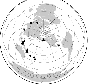
Azimuth Distribution of Events:
Prior Results for this Station
| Study | Thickness | Vp/Vs | Vp | Vs | Poissons Ratio | Extra |
| EARS | 32 km | 1.68 | 6.438 km/s | 3.844 km/s | 0.22 | |
| Crust2.0 | 34 km | 1.78 | 6.438 km/s | 3.624 km/s | 0.27 | L2,thin continental arc, Mexico, 2 km seds. |
| Global Maxima | 32 km | 1.68 | 6.438 km/s | 3.844 km/s | 0.22 | amp=0.026431805 |
| Local Maxima 1 | 65 km | 1.95 | 6.438 km/s | 3.297 km/s | 0.32 | amp=0.012955954 |
| Local Maxima 2 | 65 km | 1.89 | 6.438 km/s | 3.406 km/s | 0.31 | amp=0.008598116 |
| Local Maxima 3 | 46 km | 1.60 | 6.438 km/s | 4.024 km/s | 0.18 | amp=0.008152247 |
| Local Maxima 4 | 46 km | 1.68 | 6.438 km/s | 3.832 km/s | 0.23 | amp=0.007900756 |
| Predicted Arrivals for vertical incidence (zero ray parameter) | |
| Ps | 3.41 SECOND |
| PpPs | 13.50 SECOND |
| PsPs/PpSs | 16.91 SECOND |
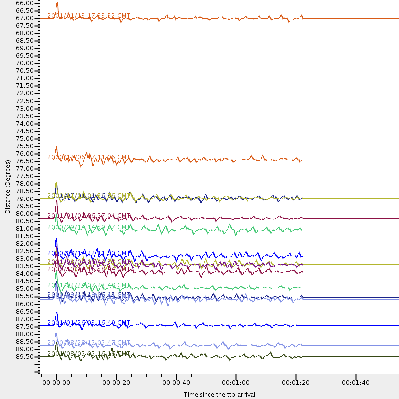
Events Processed for this Station
Download zip of receiver functions as SAC
Plot maxima for each earthquake.
Events Used in the Stack
(16 events)| Radial Match | Distance | Baz | FERegion | Time | Lat/Lon | Depth | Magnitude |
| 96.814995 | 65.8 deg | 109.16 deg | El Salvador | 2001/01/13 17:33:32 GMT | (13.0, -88.7) | 60 km | 6.4 MB, 7.8 MS, 7.7 MW, 7.5 ME |
| 96.50604 | 80.5 deg | 266.646 deg | Mindanao, Philippines | 2001/01/01 06:57:04 GMT | (6.9, 126.6) | 33 km | 6.4 MB, 7.2 MS, 7.5 MW, 7.3 ME |
| 93.96684 | 85.6 deg | 264.328 deg | Northern Molucca Sea | 2001/02/24 07:23:48 GMT | (1.3, 126.2) | 35 km | 6.6 MB, 7.0 MS, 7.1 MW, 7.1 ME |
| 92.890366 | 76.2 deg | 339.88 deg | Turkmenistan | 2000/12/06 17:11:06 GMT | (39.6, 54.8) | 30 km | 6.7 MB, 7.5 MS, 7.0 MW, 6.9 ME |
| 91.86694 | 83.9 deg | 264.373 deg | Northern Molucca Sea | 2001/08/04 01:44:53 GMT | (2.8, 127.0) | 33 km | 5.8 MB, 5.6 MS, 5.8 MW, 5.8 MW |
| 91.728546 | 79.0 deg | 238.493 deg | New Ireland Region, P.N.G. | 2000/11/16 04:54:56 GMT | (-4.0, 152.2) | 33 km | 6.0 MB, 8.2 MS, 8.0 MW, 8.0 ME |
| 89.39287 | 84.4 deg | 220.691 deg | Vanuatu Islands | 2000/10/04 16:58:44 GMT | (-15.4, 166.9) | 23 km | 6.1 MB, 6.9 MS, 6.8 MW, 6.5 ME |
| 88.498184 | 90.6 deg | 298.37 deg | Andaman Islands, India Region | 2001/08/05 05:16:16 GMT | (12.2, 93.4) | 96 km | 5.4 MB, 5.2 MS, 6.0 MW, 5.9 MW |
| 88.152504 | 89.8 deg | 260.849 deg | Banda Sea | 2000/08/28 15:05:47 GMT | (-4.1, 127.4) | 16 km | 6.5 MB, 6.8 MS, 6.8 MW, 6.7 ME |
| 87.95255 | 86.5 deg | 204.013 deg | Fiji Islands Region | 2001/07/04 07:06:31 GMT | (-21.7, -176.7) | 185 km | 5.9 MB, 5.8 MS, 6.5 MW, 6.5 MW |
| 86.48872 | 88.3 deg | 322.891 deg | Southern India | 2001/01/26 03:16:40 GMT | (23.4, 70.2) | 16 km | 6.9 MB, 8.0 MS, 7.7 MW, 7.7 ME |
| 84.123314 | 83.9 deg | 220.605 deg | Vanuatu Islands | 2001/01/09 16:49:28 GMT | (-14.9, 167.2) | 103 km | 6.3 MB, 6.6 MS, 7.6 ME, 7.0 MW |
| 83.5004 | 86.3 deg | 260.493 deg | Halmahera, Indonesia | 2000/09/10 19:06:15 GMT | (-1.1, 129.3) | 33 km | 5.9 MB, 6.0 MS, 6.1 MW, 6.1 MW |
| 82.95887 | 83.3 deg | 234.834 deg | D'Entrecasteaux Islands Region | 2000/08/14 22:11:00 GMT | (-9.3, 153.8) | 10 km | 5.1 MB, 6.0 MS |
| 82.05146 | 81.4 deg | 208.56 deg | Fiji Islands | 2000/09/14 14:59:57 GMT | (-15.7, 179.8) | 33 km | 5.7 MB, 6.2 MS, 6.3 MW, 6.2 MW |
| 80.94887 | 79.0 deg | 237.626 deg | New Britain Region, P.N.G. | 2001/07/01 01:46:06 GMT | (-4.3, 153.0) | 28 km | 5.8 MB, 6.0 MS, 6.1 MW, 6.0 ME |
Losers
(0 events)| Radial Match | Distance | Baz | FERegion | Time | Lat/Lon | Depth | Magnitude | Reason |
