
Station XE RND - REINDEER
Network: XE99 - Broadband Experiment Across Alaskan Range
Nearby stations (2 deg radius)
| Station | Name | (Lat, Lon) | Start / End | Elevation |
| RND | REINDEER | (63.41, -148.86) | 1999-06-25 / 2001-12-31 | 984 m |
| Crust2 Type: | L8,thin continental arc, Cordilleras, 0.5 km seds. |
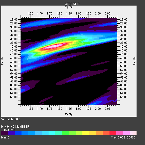
| Thickness Estimate: | 40 km |
| Thickness StdDev: | 0.9 km |
| Vp/Vs Estimate: | 1.75 |
| Vp/Vs StdDev: | 0.02 |
| Vs Estimate: | 3.741 km/s |
| Poisson's Ratio: | 0.26 |
| Peak Value: | 0.02 |
| Assumed Vp: | 6.566 km/s |
| Ps Weight: | 0.33333334 |
| PpPs Weight: | 0.33333334 |
| PsPs Weight: | 0.33333328 |
| Residual Complexity: | 0.576 |
| Nearby stations H: | 43 km +- 9.4 km |
| (2.0 deg) Vp/Vs: | 1.72 +- 0.07 |
14 with match > 90% ( 50.0 %) and 28 with match > 80% ( 100.0 %) out of 28.
Download stack as xyz text file.
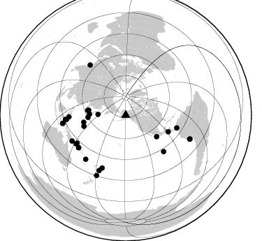
Azimuth Distribution of Events:
Prior Results for this Station
| Study | Thickness | Vp/Vs | Vp | Vs | Poissons Ratio | Extra |
| EARS | 40 km | 1.75 | 6.566 km/s | 3.741 km/s | 0.26 | |
| Crust2.0 | 34 km | 1.77 | 6.566 km/s | 3.707 km/s | 0.27 | L8,thin continental arc, Cordilleras, 0.5 km seds. |
| Global Maxima | 40 km | 1.75 | 6.566 km/s | 3.741 km/s | 0.26 | amp=0.023106502 |
| Local Maxima 1 | 41 km | 1.80 | 6.566 km/s | 3.648 km/s | 0.28 | amp=0.013836732 |
| Local Maxima 2 | 38 km | 1.81 | 6.566 km/s | 3.628 km/s | 0.28 | amp=0.008597833 |
| Local Maxima 3 | 36 km | 1.85 | 6.566 km/s | 3.544 km/s | 0.29 | amp=0.0058039445 |
| Local Maxima 4 | 38 km | 1.96 | 6.566 km/s | 3.354 km/s | 0.32 | amp=0.0052978178 |
| Predicted Arrivals for vertical incidence (zero ray parameter) | |
| Ps | 4.60 SECOND |
| PpPs | 16.78 SECOND |
| PsPs/PpSs | 21.38 SECOND |
Events Processed for this Station
Download zip of receiver functions as SAC
Plot maxima for each earthquake.
Events Used in the Stack
(28 events)| Radial Match | Distance | Baz | FERegion | Time | Lat/Lon | Depth | Magnitude |
| 96.94936 | 97.9 deg | 110.331 deg | Near Coast Of Peru | 2001/06/23 20:33:14 GMT | (-16.3, -73.6) | 33 km | 6.7 MB, 8.2 MS, 8.4 MW, 7.8 ME |
| 96.475204 | 65.3 deg | 111.406 deg | El Salvador | 2001/01/13 17:33:32 GMT | (13.0, -88.7) | 60 km | 6.4 MB, 7.8 MS, 7.7 MW, 7.5 ME |
| 95.13974 | 90.8 deg | 262.7 deg | Seram, Indonesia | 2000/08/28 15:38:06 GMT | (-4.0, 127.3) | 10 km | 5.8 MB, 5.8 MS, 6.1 MW |
| 94.07148 | 81.8 deg | 239.93 deg | New Britain Region, P.N.G. | 2000/11/17 21:01:56 GMT | (-5.5, 151.8) | 33 km | 6.2 MB, 8.0 MS, 7.6 MW, 6.9 ME |
| 93.58149 | 81.4 deg | 268.242 deg | Mindanao, Philippines | 2001/01/01 06:57:04 GMT | (6.9, 126.6) | 33 km | 6.4 MB, 7.2 MS, 7.5 MW, 7.3 ME |
| 93.47472 | 86.6 deg | 266.003 deg | Northern Molucca Sea | 2001/02/24 07:23:48 GMT | (1.3, 126.2) | 35 km | 6.6 MB, 7.0 MS, 7.1 MW, 7.1 ME |
| 93.22004 | 88.2 deg | 324.582 deg | Southern India | 2001/01/26 03:16:40 GMT | (23.4, 70.2) | 16 km | 6.9 MB, 8.0 MS, 7.7 MW, 7.7 ME |
| 92.03805 | 95.7 deg | 205.744 deg | Kermadec Islands, New Zealand | 2001/06/03 02:41:57 GMT | (-29.7, -178.6) | 178 km | 6.8 MB, 7.2 MW, 7.1 MW |
| 91.84419 | 82.7 deg | 204.101 deg | Tonga Islands | 2000/09/26 06:17:52 GMT | (-17.2, -173.9) | 56 km | 6.1 MB, 6.1 MS, 6.4 MW, 6.1 ME |
| 91.27544 | 80.2 deg | 240.167 deg | New Ireland Region, P.N.G. | 2000/11/16 04:54:56 GMT | (-4.0, 152.2) | 33 km | 6.0 MB, 8.2 MS, 8.0 MW, 8.0 ME |
| 91.16233 | 53.8 deg | 124.752 deg | Near Coast Of Jalisco, Mexico | 2001/05/20 04:21:43 GMT | (18.8, -104.4) | 33 km | 5.5 MB, 6.0 MS, 6.5 MD, 6.3 MW |
| 91.046524 | 85.2 deg | 222.342 deg | Vanuatu Islands | 2001/01/09 16:49:28 GMT | (-14.9, 167.2) | 103 km | 6.3 MB, 6.6 MS, 7.6 ME, 7.0 MW |
| 90.611855 | 85.2 deg | 244.322 deg | Eastern New Guinea Reg., P.N.G. | 2001/06/05 09:00:05 GMT | (-6.9, 146.4) | 10 km | 5.8 MB, 6.2 MS, 6.4 MW, 6.1 MW |
| 90.58221 | 87.6 deg | 205.764 deg | Fiji Islands Region | 2001/07/04 07:06:31 GMT | (-21.7, -176.7) | 185 km | 5.9 MB, 5.8 MS, 6.5 MW, 6.5 MW |
| 87.846596 | 90.8 deg | 262.583 deg | Banda Sea | 2000/08/28 15:05:47 GMT | (-4.1, 127.4) | 16 km | 6.5 MB, 6.8 MS, 6.8 MW, 6.7 ME |
| 87.31472 | 82.0 deg | 235.408 deg | Solomon Islands | 2001/04/19 21:43:42 GMT | (-7.4, 155.9) | 17 km | 6.0 MB, 6.6 MS, 6.7 MW, 6.2 ME |
| 85.28921 | 52.1 deg | 271.593 deg | Near S. Coast Of Honshu, Japan | 2000/08/18 01:52:20 GMT | (34.1, 139.2) | 10 km | 5.6 MB, 5.5 MS, 5.8 MW, 5.7 MW |
| 84.87335 | 54.3 deg | 266.604 deg | Southeast Of Honshu, Japan | 2001/04/14 23:27:26 GMT | (30.1, 141.8) | 10 km | 6.0 MB, 5.8 MS, 6.0 MW, 6.0 ME |
| 84.73152 | 39.7 deg | 271.731 deg | Kuril Islands | 2001/05/25 00:40:50 GMT | (44.3, 148.4) | 33 km | 6.1 MB, 6.7 MS, 6.7 MW, 6.6 MW |
| 84.37618 | 61.8 deg | 255.26 deg | Mariana Islands | 2001/06/15 06:17:45 GMT | (18.8, 147.0) | 33 km | 5.4 MB, 5.9 MS, 6.0 MW, 6.0 MW |
| 84.04352 | 97.6 deg | 110.553 deg | Near Coast Of Peru | 2001/07/05 13:53:48 GMT | (-16.1, -74.0) | 62 km | 6.2 MB, 6.6 MW, 6.5 ME |
| 83.852615 | 81.8 deg | 235.354 deg | Solomon Islands | 2001/04/19 20:58:26 GMT | (-7.3, 156.0) | 20 km | 5.7 MB, 6.1 MS, 6.2 MW, 5.9 ME |
| 83.255905 | 53.7 deg | 277.731 deg | Western Honshu, Japan | 2000/10/06 04:30:19 GMT | (35.5, 133.1) | 10 km | 5.8 MB, 6.8 MS, 7.0 ME, 6.7 MW |
| 82.67792 | 75.1 deg | 133.761 deg | Central East Pacific Rise | 2001/06/26 12:33:52 GMT | (-4.1, -104.5) | 10 km | 5.0 MB, 5.8 MS, 6.0 MW, 6.0 MW |
| 81.85586 | 61.1 deg | 260.526 deg | Mariana Islands Region | 2001/07/03 13:10:42 GMT | (21.6, 143.0) | 290 km | 6.0 MB, 6.5 MW, 6.5 MW |
| 81.51362 | 75.3 deg | 103.958 deg | Panama-Colombia Border Region | 2000/11/08 06:59:58 GMT | (7.0, -77.8) | 17 km | 6.0 MB, 6.4 MS, 6.5 MW, 6.2 ML |
| 80.7571 | 55.1 deg | 277.335 deg | Western Honshu, Japan | 2001/03/24 06:27:53 GMT | (34.1, 132.5) | 50 km | 6.4 MB, 6.5 MS, 6.8 MW, 6.4 ME |
| 80.66083 | 84.9 deg | 266.023 deg | Northern Molucca Sea | 2001/08/04 01:44:53 GMT | (2.8, 127.0) | 33 km | 5.8 MB, 5.6 MS, 5.8 MW, 5.8 MW |
Losers
(0 events)| Radial Match | Distance | Baz | FERegion | Time | Lat/Lon | Depth | Magnitude | Reason |
