
Station XE RNDS - Reindeer South
Network: XE99 - Broadband Experiment Across Alaskan Range
Nearby stations (2 deg radius)
| Station | Name | (Lat, Lon) | Start / End | Elevation |
| RNDS | Reindeer South | (63.39, -148.87) | 2000-06-11 / 2001-12-31 | 817 m |
| Crust2 Type: | L8,thin continental arc, Cordilleras, 0.5 km seds. |
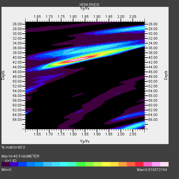
| Thickness Estimate: | 40 km |
| Thickness StdDev: | 12 km |
| Vp/Vs Estimate: | 1.82 |
| Vp/Vs StdDev: | 0.11 |
| Vs Estimate: | 3.608 km/s |
| Poisson's Ratio: | 0.28 |
| Peak Value: | 0.02 |
| Assumed Vp: | 6.566 km/s |
| Ps Weight: | 0.33333334 |
| PpPs Weight: | 0.33333334 |
| PsPs Weight: | 0.33333328 |
| Residual Complexity: | 0.530 |
| Nearby stations H: | 46 km +- 9.0 km |
| (2.0 deg) Vp/Vs: | 1.73 +- 0.08 |
3 with match > 90% ( 50.0 %) and 6 with match > 80% ( 100.0 %) out of 6.
Download stack as xyz text file.
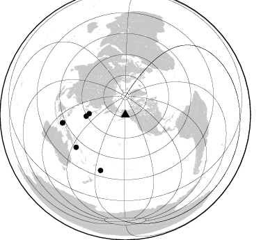
Azimuth Distribution of Events:
Prior Results for this Station
| Study | Thickness | Vp/Vs | Vp | Vs | Poissons Ratio | Extra |
| EARS | 40 km | 1.82 | 6.566 km/s | 3.608 km/s | 0.28 | |
| Crust2.0 | 34 km | 1.77 | 6.566 km/s | 3.707 km/s | 0.27 | L8,thin continental arc, Cordilleras, 0.5 km seds. |
| Global Maxima | 40 km | 1.82 | 6.566 km/s | 3.608 km/s | 0.28 | amp=0.016572164 |
| Local Maxima 1 | 37 km | 1.99 | 6.566 km/s | 3.304 km/s | 0.33 | amp=0.00815787 |
| Local Maxima 2 | 70 km | 2.03 | 6.566 km/s | 3.243 km/s | 0.34 | amp=0.00737248 |
| Local Maxima 3 | 28 km | 2.10 | 6.566 km/s | 3.13 km/s | 0.35 | amp=0.0068373405 |
| Local Maxima 4 | 43 km | 1.74 | 6.566 km/s | 3.774 km/s | 0.25 | amp=0.0049682073 |
| Predicted Arrivals for vertical incidence (zero ray parameter) | |
| Ps | 5.06 SECOND |
| PpPs | 17.39 SECOND |
| PsPs/PpSs | 22.45 SECOND |
Events Processed for this Station
Download zip of receiver functions as SAC
Plot maxima for each earthquake.
Events Used in the Stack
(6 events)| Radial Match | Distance | Baz | FERegion | Time | Lat/Lon | Depth | Magnitude |
| 95.62035 | 56.4 deg | 267.845 deg | Bonin Islands, Japan Region | 2000/08/06 07:27:12 GMT | (28.9, 139.6) | 395 km | 6.3 MB, 7.3 MW, 7.3 MW |
| 95.10882 | 90.8 deg | 262.693 deg | Seram, Indonesia | 2000/08/28 15:38:06 GMT | (-4.0, 127.3) | 10 km | 5.8 MB, 5.8 MS, 6.1 MW |
| 91.094376 | 90.8 deg | 262.576 deg | Banda Sea | 2000/08/28 15:05:47 GMT | (-4.1, 127.4) | 16 km | 6.5 MB, 6.8 MS, 6.8 MW, 6.7 ME |
| 85.09798 | 87.4 deg | 203.961 deg | Tonga Islands | 2000/08/17 00:04:29 GMT | (-21.9, -174.8) | 33 km | 5.4 MB, 5.8 MS, 5.9 MW, 5.7 MW |
| 85.07109 | 52.1 deg | 271.599 deg | Near S. Coast Of Honshu, Japan | 2000/08/18 01:52:20 GMT | (34.1, 139.2) | 10 km | 5.6 MB, 5.5 MS, 5.8 MW, 5.7 MW |
| 81.16855 | 84.5 deg | 236.533 deg | D'Entrecasteaux Islands Region | 2000/08/14 22:11:00 GMT | (-9.3, 153.8) | 10 km | 5.1 MB, 6.0 MS |
Losers
(0 events)| Radial Match | Distance | Baz | FERegion | Time | Lat/Lon | Depth | Magnitude | Reason |
