
Station XE SAN - Sanctuary
Network: XE99 - Broadband Experiment Across Alaskan Range
Nearby stations (2 deg radius)
| Station | Name | (Lat, Lon) | Start / End | Elevation |
| SAN | Sanctuary | (63.72, -149.48) | 2000-06-12 / 2001-12-31 | 780 m |
| Crust2 Type: | L8,thin continental arc, Cordilleras, 0.5 km seds. |
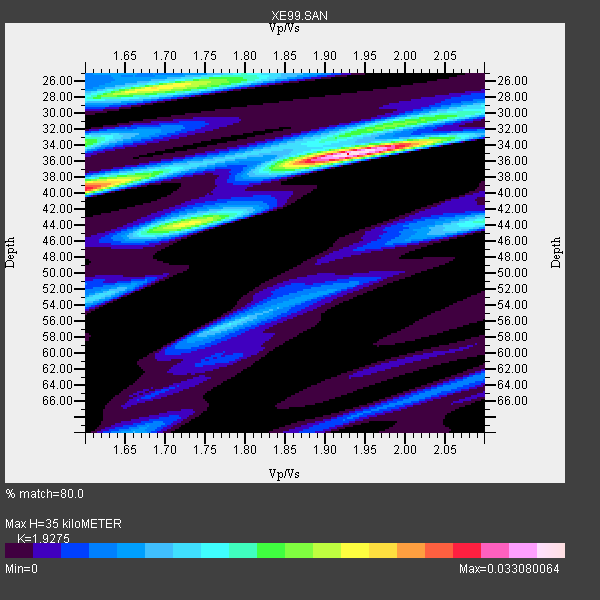
| Thickness Estimate: | 35 km |
| Thickness StdDev: | 5.6 km |
| Vp/Vs Estimate: | 1.93 |
| Vp/Vs StdDev: | 0.16 |
| Vs Estimate: | 3.407 km/s |
| Poisson's Ratio: | 0.32 |
| Peak Value: | 0.03 |
| Assumed Vp: | 6.566 km/s |
| Ps Weight: | 0.33333334 |
| PpPs Weight: | 0.33333334 |
| PsPs Weight: | 0.33333328 |
| Residual Complexity: | 0.680 |
| Nearby stations H: | +- |
| (2.0 deg) Vp/Vs: | +- |
2 with match > 90% ( 10.526316 %) and 19 with match > 80% ( 100.0 %) out of 19.
Download stack as xyz text file.
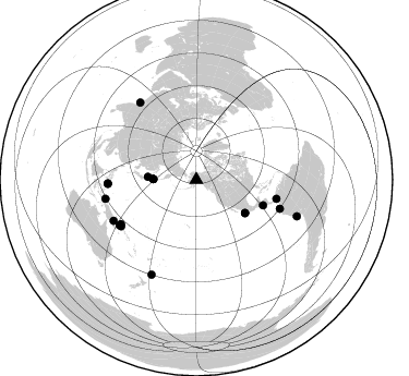
Azimuth Distribution of Events:
Prior Results for this Station
| Study | Thickness | Vp/Vs | Vp | Vs | Poissons Ratio | Extra |
| EARS | 35 km | 1.93 | 6.566 km/s | 3.407 km/s | 0.32 | |
| Crust2.0 | 34 km | 1.77 | 6.566 km/s | 3.707 km/s | 0.27 | L8,thin continental arc, Cordilleras, 0.5 km seds. |
| Global Maxima | 35 km | 1.93 | 6.566 km/s | 3.407 km/s | 0.32 | amp=0.033080064 |
| Local Maxima 1 | 39 km | 1.60 | 6.566 km/s | 4.097 km/s | 0.18 | amp=0.023224398 |
| Local Maxima 2 | 27 km | 1.69 | 6.566 km/s | 3.897 km/s | 0.23 | amp=0.021484563 |
| Local Maxima 3 | 44 km | 1.71 | 6.566 km/s | 3.84 km/s | 0.24 | amp=0.016819254 |
| Local Maxima 4 | 34 km | 1.60 | 6.566 km/s | 4.104 km/s | 0.18 | amp=0.016366953 |
| Predicted Arrivals for vertical incidence (zero ray parameter) | |
| Ps | 4.94 SECOND |
| PpPs | 15.60 SECOND |
| PsPs/PpSs | 20.55 SECOND |
Events Processed for this Station
Download zip of receiver functions as SAC
Plot maxima for each earthquake.
Events Used in the Stack
(19 events)| Radial Match | Distance | Baz | FERegion | Time | Lat/Lon | Depth | Magnitude |
| 94.2696 | 65.6 deg | 110.944 deg | El Salvador | 2001/01/13 17:33:32 GMT | (13.0, -88.7) | 60 km | 6.4 MB, 7.8 MS, 7.7 MW, 7.5 ME |
| 93.117424 | 54.2 deg | 124.277 deg | Near Coast Of Jalisco, Mexico | 2001/05/20 04:21:43 GMT | (18.8, -104.4) | 33 km | 5.5 MB, 6.0 MS, 6.5 MD, 6.3 MW |
| 88.74051 | 39.4 deg | 270.801 deg | Kuril Islands | 2001/05/25 00:40:50 GMT | (44.3, 148.4) | 33 km | 6.1 MB, 6.7 MS, 6.7 MW, 6.6 MW |
| 87.79785 | 81.2 deg | 267.366 deg | Mindanao, Philippines | 2001/01/02 07:30:03 GMT | (6.7, 126.8) | 33 km | 5.8 MB, 6.2 MS, 6.4 MW, 6.3 MW |
| 87.74517 | 87.7 deg | 324.032 deg | Southern India | 2001/01/26 03:16:40 GMT | (23.4, 70.2) | 16 km | 6.9 MB, 8.0 MS, 7.7 MW, 7.7 ME |
| 87.29562 | 54.2 deg | 124.421 deg | Near Coast Of Jalisco, Mexico | 2001/04/29 21:26:54 GMT | (18.7, -104.5) | 10 km | 5.2 MB, 5.5 MS, 6.1 MW, 6.1 MW |
| 87.26451 | 81.2 deg | 267.639 deg | Mindanao, Philippines | 2001/01/01 06:57:04 GMT | (6.9, 126.6) | 33 km | 6.4 MB, 7.2 MS, 7.5 MW, 7.3 ME |
| 87.10371 | 75.6 deg | 103.469 deg | Panama-Colombia Border Region | 2000/11/08 06:59:58 GMT | (7.0, -77.8) | 17 km | 6.0 MB, 6.4 MS, 6.5 MW, 6.2 ML |
| 86.64616 | 80.1 deg | 239.543 deg | New Ireland Region, P.N.G. | 2000/11/16 04:54:56 GMT | (-4.0, 152.2) | 33 km | 6.0 MB, 8.2 MS, 8.0 MW, 8.0 ME |
| 85.26399 | 39.4 deg | 270.62 deg | Kuril Islands | 2001/06/24 13:18:51 GMT | (44.2, 148.5) | 33 km | 5.8 MB, 5.7 MS, 6.0 MW |
| 84.39849 | 81.0 deg | 109.157 deg | Near Coast Of Ecuador | 2000/09/28 23:23:43 GMT | (-0.2, -80.6) | 23 km | 5.8 MB, 6.0 MS, 6.6 MW, 6.4 MW |
| 84.06756 | 39.7 deg | 270.91 deg | Kuril Islands | 2001/03/23 11:30:10 GMT | (44.1, 148.1) | 33 km | 5.9 MB, 5.7 MS, 6.0 MW, 5.9 MW |
| 84.047066 | 81.7 deg | 239.318 deg | New Britain Region, P.N.G. | 2000/11/17 21:01:56 GMT | (-5.5, 151.8) | 33 km | 6.2 MB, 8.0 MS, 7.6 MW, 6.9 ME |
| 83.10441 | 44.7 deg | 273.243 deg | Hokkaido, Japan Region | 2001/08/13 20:11:23 GMT | (41.0, 142.3) | 38 km | 6.0 MB, 6.3 MS, 6.4 MW, 6.3 ME |
| 83.093704 | 84.5 deg | 243.586 deg | Eastern New Guinea Reg., P.N.G. | 2001/06/30 16:34:36 GMT | (-6.4, 146.8) | 104 km | 5.8 MB, 6.0 MW, 6.0 MW |
| 82.19233 | 80.9 deg | 238.189 deg | New Ireland Region, P.N.G. | 2000/11/16 07:42:16 GMT | (-5.2, 153.1) | 30 km | 6.2 MB, 7.8 MS, 7.6 MW, 7.3 ME |
| 81.859856 | 98.0 deg | 109.973 deg | Near Coast Of Peru | 2001/07/05 13:53:48 GMT | (-16.1, -74.0) | 62 km | 6.2 MB, 6.6 MW, 6.5 ME |
| 80.26715 | 95.9 deg | 205.231 deg | Kermadec Islands, New Zealand | 2001/06/03 02:41:57 GMT | (-29.7, -178.6) | 178 km | 6.8 MB, 7.2 MW, 7.1 MW |
| 80.11807 | 84.9 deg | 258.195 deg | Irian Jaya Region, Indonesia | 2001/01/29 23:21:25 GMT | (-0.7, 133.3) | 33 km | 5.9 MB, 5.8 MS, 6.2 MW, 6.1 MW |
Losers
(0 events)| Radial Match | Distance | Baz | FERegion | Time | Lat/Lon | Depth | Magnitude | Reason |
